| ||||||||||||||||||||||||||||||||||||||||||||||||||||||||||||||||||||
| ||||||||||||||||||||||||||||||||||||||||||||||||||||||||||||||||||||
| ||||||||||||||||||||||||||||||||||||||||||||||||||||||||||||||||||||
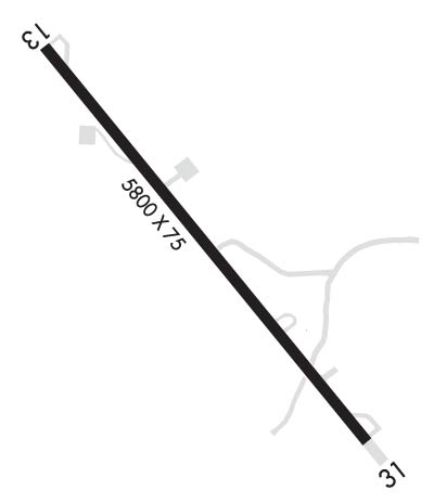
| Rwy | Rwy | |||||||
| 5800x75 | 5800' | 5800x75 | 5800' | |||||
| Runway ID | Single Wheel | Double Wheel | Double Tandem Wheel | Dual Double Wheel |
| 13/31 | 50,000 | 75,000 | N/A | N/A |
| These numbers are Advisory and are not limits. The Airport Manager should have more accurate Weight Limits | ||||
 Airport Diagram might not be current. | |
| Facility Name: | DEER LODGE-CITY-COUNTY |
| City Name: | DEER LODGE |
| County: | POWELL |
| State abbrev: | MT |
| State Name: | MONTANA |
| Ownership: | PUBLICLY OWNED |
| Use: | OPEN TO THE PUBLIC |
| Owner's Name: | CITY OF DEER LODGE & POWELL CO |
| Address: | 409 MISSOURI AVE STE 203 |
| DEER LODGE, MT 59722-1084 | |
| Owner's Phone: | 406-846-9723 |
| Manager's Name: | TONY PFAFF |
| Address: | 2944 GREENHOUSE ROAD |
| DEER LODGE, MT 59722 | |
| Phone: | 406-490-3071; ALSO 406-846-3825. OR 406-490-0297 OR 406-490-3071 |
| FAA Region: | NORTHWEST MOUNTAIN |
| FAA Field Office: | HLN |
| Date | Sunrise | Sunset |
|---|---|---|
| 04/24/24 Wednesday | 6:27 | 20:32 |
| 04/25/24 Thursday | 6:25 | 20:33 |
| 04/26/24 Friday | 6:24 | 20:35 |
| 04/27/24 Saturday | 6:22 | 20:36 |
| 04/28/24 Sunday | 6:20 | 20:37 |
| 04/29/24 Monday | 6:19 | 20:39 |
| 04/30/24 Tuesday | 6:17 | 20:40 |
| 05/01/24 Wednesday | 6:16 | 20:41 |
| 05/02/24 Thursday | 6:14 | 20:42 |
| 05/03/24 Friday | 6:13 | 20:44 |
| 05/04/24 Saturday | 6:11 | 20:45 |
| 05/05/24 Sunday | 6:10 | 20:46 |
| 05/06/24 Monday | 6:08 | 20:48 |
| 05/07/24 Tuesday | 6:07 | 20:49 |
| Airport Attendance Schedule | UNATTENDED |
| Airport Status | OPERATIONAL (This Status can change at any time - please check NOTAMS) |
| Airport Lighting Schedule | ACTVT MIRL RY 13/31 & PAPI RYS 13 & 31 - CTAF. |
| Airport Storage Available | Tie Downs |
| Extra Services Available | Crop Dusting |
| Wind Indicator | YES - (lighted) |
| Control Tower | NO |
| CTAF Frequency | 122.900 |
| Unicom Frequency | |
| Rotating Beacon Color | WG |
| Segmented Circle | YES |
| Landing Fee | NO |
| Airport Inspected | STATE - performed by STATE AERONAUTICAL PERSONNEL |
| Inspection Date | 05/12/2023 |
| Type of Fuel Available | Grade 100LL, JET A (freeze point -40C) |
| Airframe Repair Service | NONE |
| Power Plant Repair Service | NONE |
| Latitude | N4623.3 |
| Longitude | W11245.9 (ESTIMATED) |
| Arpt Elevation | 4692ft (SURVEYED) |
| Magnetic Variation | 13E |
| 2 miles W | of DEER LODGE |
| Traffic Pattern Altitude | |
| Sectional Chart | GREAT FALLS |
| Operations (Reported) | Yearly | Avg. Daily |
|---|---|---|
| General Aviation Transient | 1500 | 4 |
| General Aviation Local | 1750 | 5 |
| Air Taxi | 500 | 1 |
| Commerical | 0 | 0 |
| Commuter | 0 | 0 |
| Military | 300 | 1 |
| Aircraft based on Field | |
|---|---|
| General Aviation Singles | 9 |
| General Aviation Multi | 0 |
| Jet Aircraft | 2 |
| General Aviation Helicopters | 7 |
| Military Aircraft | 0 |
| Gliders | 0 |
| Ultralights | 0 |
| FSS on field | NO |
| FSS tie-in | GREAT FALLS |
| FSS Phone | 1-800-WX-BRIEF |
| Who issues Notams | GTF |
| Notam D service at airport | YES |
| ARTCC Name | SALT LAKE CITY |
| Airport Certification | |
| Aircraft Rescue & Firefighting Index | None |
| Airport of Entry | No |
| Custom Landing Rights | No |
| Joint Civil/Military | No |
| Military Landing rights | YES |
| NATIONAL PLAN OF INTEGRATED AIRPORT SYSTEMS (NPIAS) |
| GRANT AGREEMENTS UNDER FAAP/ADAP/AIP |
| ASSURANCES PURSUANT TO TITLE VI, CIVIL RIGHTS ACT OF 1964 |
| SINGLE WHEEL APRON WEIGHT BEARING CAPACITY 30,000 LBS FOR SW APRON, 50,000 LBS FOR NE APRON, TWY TO NE APRON 50,000 LBS. |
| FOR CD CTC SALT LAKE ARTCC AT 801-320-2568. |
| COLD TEMPERATURE AIRPORT. ALTITUDE CORRECTION REQUIRED AT OR BELOW -23C. |
| RWY 13/3 1 RY 13/31 EXTDD SE END. |
Airport Communications & Frequencies:
| |||||||
| Runway: 13 | Runway: 31 | ||
| Mag heading: | 128° | Mag heading: | 308° |
| Rwy Slope: | -1.11% Down | Rwy Slope: | 1.11% Up |
| Approach: | Approach: | ||
| Pattern: | Left Traffic | Pattern: | Left Traffic |
| Markings: | NONPRECISION INSTRUMENT | Markings: | NONPRECISION INSTRUMENT |
| Marking Condition: | GOOD | Marking Condition: | GOOD |
| Arresting Dev: | Arresting Dev: | ||
| Lat & Long: | N4623.6 W11246.3 | Lat. & Long.: | N4622.8 W11245.4 |
| Elev: | 4692.7 ft. MSL | Elev: | 4628.1 ft. MSL |
| TCH: | 35 ft. AGL | TCH: | 25 ft. AGL |
| Visual Glide Path: | 3.22 degrees | Visual Glide Path: | 2.72 degrees |
| Displaced Threshold: | No | Displaced Threshold: | No |
| Touchdown Zone: | YES | Touchdown Zone: | YES |
| Touchdown Elev.: | 4692.7 feet | Touchdown Elev.: | 4650.8 feet |
| Visual Glide Slope: | 2-Light PAPI on LEFT side of Runway | Visual Glide Slope: | 2-Light PAPI on LEFT side of Runway |
| RVR Equipment: | RVR Equipment: | ||
| RVV Equipment: | NO | RVV Equipment: | NO |
| Approach Lights: | Approach Lights: | ||
| REIL: | NO | REIL: | NO |
| Centerline Lights: | NO | Centerline Lights: | NO |
| Touchdown lights: | NO | Touchdown lights: | NO |
| Runway Category: | Runway with a Visual Approach | Runway Category: | Runway with a Visual Approach |
| Declared Distances: | Declared Distances: |