Approach Charts
| FltPlan does not have IFR approach charts available for K36S. |
Current Weather/Notams (Metars, TAFs, Notams, NWS Forecast, PIREPS, and nearby weather)
Customs Information Send updates to Support@FltPlan.com
Customs Not Available
Database effective 04/18/2024
Airport Diagram might not be current.
|
| Facility Name: | HAPPY CAMP |
| City Name: | HAPPY CAMP |
| County: | SISKIYOU |
| State abbrev: | CA |
| State Name: | CALIFORNIA |
| | |
| Ownership: | PUBLICLY OWNED |
| Use: | OPEN TO THE PUBLIC |
| Owner's Name: | U.S. FOREST SERVICE; OPERD/MAINTD BY SISKIYOU COUNTY. |
| Address: | 63822 HIGHWAY 96 |
| | HAPPY CAMP, CA 96039-0377 |
| Owner's Phone: | 530-493-1730 |
| | |
| Manager's Name: | ANGIE STUMBAUGH; DIRECTOR OF AIRPORTS OFFICE IN YREKA. ASTUMBAUGH@CO.SISKIYOU.CA.US. |
| Address: | 190 GREENHORN ROAD |
| | YREKA, CA 96097 |
| Phone: | 530-842-8297 |
| | |
| FAA Region: | WESTERN-PACIFIC |
| FAA Field Office: | SFO |
Runway Identifications
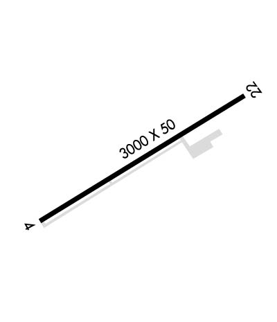
Runway Identification: 04/22Length: 3000 ft
Width: 50 ft
Surface: ASPHALT-FAIR CONDITION
Edge lights: Treatment: NONE
| | Runway: 04 | | Runway: 22 |
| Mag heading: | N/A | Mag heading: | N/A |
| Approach: | | Approach: | |
| Pattern: | Right Traffic | Pattern: | Left Traffic |
| Markings: | BASIC | Markings: | BASIC |
| Marking Condition: | FAIR | Marking Condition: | FAIR |
| Arresting Dev: | | Arresting Dev: | |
| Lat & Long: | N4147.3 W12323.6 | Lat. & Long.: | N4147.6 W12323.1 |
| Elev: | N/A | Elev: | N/A |
| TCH: | | TCH: | |
| Visual Glide Path: | | Visual Glide Path: | |
| Displaced Threshold: | No | Displaced Threshold: | No |
| Touchdown Zone: | NO | Touchdown Zone: | NO |
| Touchdown Elev.: | | Touchdown Elev.: | |
| Visual Glide Slope: | | Visual Glide Slope: | |
| RVR Equipment: | | RVR Equipment: | |
| RVV Equipment: | NO | RVV Equipment: | NO |
| Approach Lights: | | Approach Lights: | |
| REIL: | NO | REIL: | NO |
| Centerline Lights: | NO | Centerline Lights: | NO |
| Touchdown lights: | NO | Touchdown lights: | NO |
| Runway Category: | Runway with a Visual Approach | Runway Category: | Runway with a Visual Approach |
| Declared Distances: | | Declared Distances: | |
| Obstructions: | TREE; RY 04 TREE AND SHRUB COVERED RISING TERRAIN. | Obstructions: | BRUSH; RY 22 TREE AND SHRUB COVERED RISING TERRAIN. |
| Marked: | NOT Marked/Lighted | Marked: | NOT Marked/Lighted |
| Clearance slope: | 12:1; RY 04 APCH SLOPE 12:1 DUE TO 25 FT TREE 500 FT FM THLD. | Clearance slope: | RY 22 APCH SLOPE 0:0 DUE TO 10 FT SHRUBS 200 FT FM THLD. |
| Obstruction height: | 25 feet AGL | Obstruction height: | 10 feet AGL |
| Dist. from runway: | 500 feet | Dist. from runway: | 200 feet |
| Centerline offset: | 120 left of centerline | Centerline offset: | 125 feet right of centerline |
| Comments: | RWY 04 HAS 3 FT FENCE O FEET FROM RWY END AND 80 FEET L. | Comments: | RY 22 HAS 8 FT SHRUB 0 FEET FM RY END AND 115 FT RIGHT. |

