Click here for more info on on SMS!

K35A

UNION COUNTY, TROY SHELTON FLD
UNION
SC
Time Zone: Eastern
Lat: N 3441.2
Long: W 08138.5
Elev: 610
Var: +06
Longest Runway: 3508
CTAF: 122.7

FBO & Flight Services info for K35A

FBOs: Update your Fuel Prices
Providing high quality fuel and services to you and your customers, from Phillips 66 Aviation.
Ph: 864-429-1680
-
Freq: 122.7WebsiteE-Mail
Service
Jet
100LL
SAF
MoGas
Full        Last Update: 04/01/2024 10:17

Self  4.95    
Misc. Info: Address: 198 AIRPORT RD   UNION, SC 29379

If you are an FBO, call 1-203-262-1700 to update your info or email: FltPlan.Advertising@garmin.com
Advertise your FBO on FltPlan.com

Runway & Approach Info for K35A
Rwy
Length
Land Dist**
Approach*
  Rwy
Length
Land Dist**
Approach*
05
3508x60  3508'          
 
  
23
  3508x60  3508'          
 
 * only ILS, LOC, LDA, and SDF approaches to a specific runway are shown
** For any Declared Landing Distance Available, please see A/FD or Approach plates
Runway Weight Capability (lbs.) Help
Runway IDSingle WheelDouble WheelDouble Tandem WheelDual Double Wheel
05/2312,500N/AN/AN/A
These numbers are Advisory and are not limits.   The Airport Manager should have more accurate Weight Limits
Approach Charts
Approaches    
Current Weather/Notams
Customs Information Send updates to Support@FltPlan.com
Customs Not Available
Database effective 05/16/2024
Airport Diagram of K35A
Airport Diagram might not be current.

Facility Name: UNION COUNTY, TROY SHELTON FLD
City Name: UNION
County: UNION
State abbrev: SC
State Name: SOUTH CAROLINA
   
Ownership: PUBLICLY OWNED
Use: OPEN TO THE PUBLIC
Owner's Name: UNION COUNTY
Address: PO DRAWER G
 UNION, SC 29379
Owner's Phone: 864-429-1600
  
Manager's Name: RONNIE WADE
Address: UNION COUNTY AIRPORT, 198 AIRPORT RD
 UNION, SC 29379
Phone: 864-429-1680
   
FAA Region: SOUTHERN
FAA Field Office: ATL


Sunrise / Sunset times for UNION COUNTY, TROY SHELTON FLD

DateSunriseSunset
04/23/24 Tuesday6:4420:06
04/24/24 Wednesday6:4320:07
04/25/24 Thursday6:4220:07
04/26/24 Friday6:4120:08
04/27/24 Saturday6:4020:09
04/28/24 Sunday6:3920:10
04/29/24 Monday6:3820:11
04/30/24 Tuesday6:3720:11
05/01/24 Wednesday6:3520:12
05/02/24 Thursday6:3420:13
05/03/24 Friday6:3320:14
05/04/24 Saturday6:3220:15
05/05/24 Sunday6:3220:15
05/06/24 Monday6:3120:16

Airport Facilities

Airport Attendance ScheduleMON-FRI 0800-1700
Airport Status OPERATIONAL (This Status can change at any time - please check NOTAMS)
Airport Lighting ScheduleMIRL RY 05/23 PRESET MED INTST DUSK-0000; AFTER 0000 ACTVT - CTAF. ACTVT PAPI RYS 05 & 23 - CTAF.
Airport Storage AvailableTie Downs, Hanger
Extra Services AvailableNONE
Wind IndicatorYES - (lighted)
Control TowerNO
CTAF Frequency122.700
Unicom Frequency122.700
Rotating Beacon ColorWG
Segmented CircleYES
Landing FeeNO

Airport Inspection Data

Airport InspectedSTATE - performed by STATE AERONAUTICAL PERSONNEL
Inspection Date06/14/2022

Airport Services

Type of Fuel AvailableGrade 100LL; -10SELF-SERVE FUEL AVBL 24 HRS. FOR SVC AFT HRS CALL 864-426-3003.
Airframe Repair ServiceMAJOR
Power Plant Repair ServiceMAJOR

Geographic Data

LatitudeN3441.2
LongitudeW08138.5 (ESTIMATED)
Arpt Elevation610ft (ESTIMATED)
Magnetic Variation06W
1 miles SWof UNION
Traffic Pattern Altitude
Sectional ChartATLANTA

Aircraft Data

Operations (Reported)YearlyAvg. Daily
General Aviation Transient 16715
General Aviation Local 13294
Air Taxi 00
Commerical 00
Commuter 00
Military 00
Aircraft based on Field
General Aviation Singles 10
General Aviation Multi 0
Jet Aircraft 0
General Aviation Helicopters 0
Military Aircraft 0
Gliders 1
Ultralights 1

FAA Services

FSS on field NO
FSS tie-in ANDERSON
FSS Phone 1-800-WX-BRIEF
Who issues Notams AND
Notam D service at airport YES
ARTCC Name ATLANTA

Federal Status

Airport Certification
Aircraft Rescue & Firefighting IndexNone
Airport of EntryNo
Custom Landing RightsNo
Joint Civil/MilitaryNo
Military Landing rightsYES

Federal Agreements

NATIONAL PLAN OF INTEGRATED AIRPORT SYSTEMS (NPIAS)
GRANT AGREEMENTS UNDER FAAP/ADAP/AIP
ASSURANCES PURSUANT TO TITLE VI, CIVIL RIGHTS ACT OF 1964

Remarks

FOR CD CTC GREER APCH AT 864-877-8275. WHEN GREER APCH CLSD, FOR CD CTC ATLANTA ARTCC AT 770-210-7692.
Airport Communications & Frequencies:
CTAF Frequency:
122.700
Unicom Frequency:
122.700
Remarks
  • APCH/DEP SVC PRVDD BY ATLANTA ARTCC ON FREQS 135.35/263.125 (OWING RCAG) WHEN APCH CTL CLSD.
  • GREER Primary Approach Frequencies:  
    119.4
    350.2
    GREER Primary Departure Frequencies:  
    119.4
    350.2
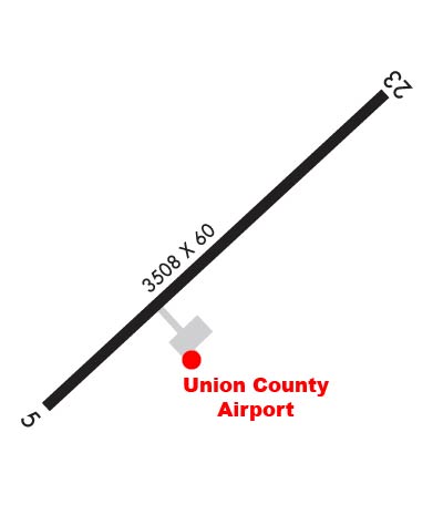
    Runway Identifications
    Runway Identification: 05/23
    Length: 3508 ft
    Width: 60 ft
    Surface: ASPHALT-GOOD CONDITION
    Edge lights: Medium Intensity

    Treatment: NONE

     Runway: 05   Runway: 23
    Mag heading: 53°Mag heading: 233°
    Rwy Slope: 1.04% UpRwy Slope: -1.04% Down
    Approach: Approach:
    Pattern: Left TrafficPattern: Left Traffic
    Markings: NONPRECISION INSTRUMENTMarkings: BASIC
    Marking Condition: GOODMarking Condition: GOOD
    Arresting Dev: Arresting Dev:
    Lat & Long: N3441.0  W08138.7Lat. & Long.: N3441.4  W08138.2
    Elev: 573.4 ft. MSLElev: 610.0 ft. MSL
    TCH: 40 ft. AGLTCH: 38 ft. AGL
    Visual Glide Path: 4.00 degreesVisual Glide Path: 4.00 degrees
    Displaced Threshold: NoDisplaced Threshold: No
    Touchdown Zone: YESTouchdown Zone: YES
    Touchdown Elev.: 604.1 feetTouchdown Elev.: 610.2 feet
    Visual Glide Slope: 2-Light PAPI on LEFT side of RunwayVisual Glide Slope: 2-Light PAPI on LEFT side of Runway
    RVR Equipment: RVR Equipment:
    RVV Equipment: NORVV Equipment: NO
    Approach Lights: Approach Lights:
    REIL: NOREIL: NO
    Centerline Lights: NOCenterline Lights: NO
    Touchdown lights: NOTouchdown lights: NO
    Runway Category: Runway with a Non-precision ApproachRunway Category: Runway with a Non-precision Approach
    Declared Distances: Declared Distances:
    Obstructions: TREEObstructions:
    Marked: NOT Marked/LightedMarked:
    Clearance slope: 1:1Clearance slope: 20:1
    Obstruction height: 14 feet AGLObstruction height:
    Dist. from runway: 211 feetDist. from runway:
    Centerline offset: 89 left of centerlineCenterline offset:
    Comments: TREES CLOSE-IN, 142 FT FROM RWY END BOTH SIDES OF RWY 5 APCH 112 FT FROM CNTRLN.Comments:
    C:1/P: