Approach Charts
| FltPlan does not have IFR approach charts available for K33S. |
Current Weather/Notams (Metars, TAFs, Notams, NWS Forecast, PIREPS, and nearby weather)
Customs Information Send updates to Support@FltPlan.com
Customs Not Available
Database effective 04/18/2024
Airport Diagram might not be current.
|
| Facility Name: | PRU FLD |
| City Name: | RITZVILLE |
| County: | ADAMS |
| State abbrev: | WA |
| State Name: | WASHINGTON |
| | |
| Ownership: | PUBLICLY OWNED |
| Use: | OPEN TO THE PUBLIC |
| Owner's Name: | CITY OF RITZVILLE |
| Address: | 216 E. MAIN |
| | RITZVILLE, WA 99169-1417 |
| Owner's Phone: | 509-659-1930 |
| | |
| Manager's Name: | DAVE BREAZEALE |
| Address: | 216 E. MAIN |
| | RITZVILLE, WA 99169-1417 |
| Phone: | 509-659-1930 |
| | |
| FAA Region: | NORTHWEST MOUNTAIN |
| FAA Field Office: | SEA |
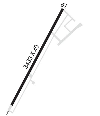
Runway Identifications
Runway Identification: 01/19Length: 3433 ft
Width: 40 ft
Surface: ASPHALT-GOOD CONDITION
Edge lights: Medium IntensityTreatment: NONE
| | Runway: 01 | | Runway: 19 |
| Mag heading: | 9° | Mag heading: | 189° |
| Rwy Slope: | .52% Up | Rwy Slope: | -.52% Down |
| Approach: | | Approach: | |
| Pattern: | Left Traffic | Pattern: | Left Traffic |
| Markings: | BASIC | Markings: | BASIC |
| Marking Condition: | FAIR | Marking Condition: | FAIR |
| Arresting Dev: | | Arresting Dev: | |
| Lat & Long: | N4707.2 W11823.6 | Lat. & Long.: | N4707.7 W11823.2 |
| Elev: | 1783.0 ft. MSL | Elev: | 1801.0 ft. MSL |
| TCH: | 40 ft. AGL | TCH: | 45 ft. AGL |
| Visual Glide Path: | 4.00 degrees | Visual Glide Path: | 3.50 degrees |
| Displaced Threshold: | No | Displaced Threshold: | 820 feet |
| Touchdown Zone: | YES | Touchdown Zone: | YES |
| Touchdown Elev.: | 1799.0 feet | Touchdown Elev.: | 1801.0 feet |
| Visual Glide Slope: | 2-Light PAPI on LEFT side of Runway | Visual Glide Slope: | 2-Light PAPI on RIGHT side of Runway |
| RVR Equipment: | | RVR Equipment: | |
| RVV Equipment: | NO | RVV Equipment: | NO |
| Approach Lights: | | Approach Lights: | |
| REIL: | NO | REIL: | NO |
| Centerline Lights: | NO | Centerline Lights: | NO |
| Touchdown lights: | NO | Touchdown lights: | NO |
| Runway Category: | Runway with a Visual Approach | Runway Category: | Runway with a Visual Approach |
| Declared Distances: | TORA:2614' TODA:2614' ASDA:3433' LDA:3433' | Declared Distances: | TORA:3433' TODA:3433' ASDA:3433' LDA:2614' |
| Obstructions: | PLINE | Obstructions: | TREE |
| Marked: | NOT Marked/Lighted | Marked: | NOT Marked/Lighted |
| Clearance slope: | 39:1 | Clearance slope: | 7:1 |
| Obstruction height: | 27 feet AGL | Obstruction height: | 48 feet AGL |
| Dist. from runway: | 1282 feet | Dist. from runway: | 540 feet |
| Centerline offset: | 69 right of centerline | Centerline offset: | 32 feet right of centerline |
| Comments: | | Comments: | HOUSES, ROAD, SIGNS, AND TRESS FM 0-200 FT OF THR. 60 FT TREE 170 FT FM THR, 70 FT R. |

