
| ||||||||||||||||||||||||||||||||||||||||||||
| ||||||||||||||||||||||||||||||||||||||||||||
| Rwy | Rwy | |||||||
| 3809x75 | 3809' | 3809x75 | 3809' | |||||
| Runway ID | Single Wheel | Double Wheel | Double Tandem Wheel | Dual Double Wheel |
| 12/30 | 12,500 | N/A | N/A | N/A |
| These numbers are Advisory and are not limits. The Airport Manager should have more accurate Weight Limits | ||||
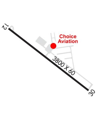 Airport Diagram might not be current. | |
| Facility Name: | STEVENSVILLE |
| City Name: | STEVENSVILLE |
| County: | RAVALLI |
| State abbrev: | MT |
| State Name: | MONTANA |
| Ownership: | PUBLICLY OWNED |
| Use: | OPEN TO THE PUBLIC |
| Owner's Name: | TOWN OF STEVENSVILLE |
| Address: | PO BOX 30 |
| STEVENSVILLE, MT 59870 | |
| Owner's Phone: | 406-777-5271 |
| Manager's Name: | WILLIAM ROWE |
| Address: | PO BOX 30 |
| STEVENSVILLE, MT 59870 | |
| Phone: | 406-381-1764 |
| FAA Region: | NORTHWEST MOUNTAIN |
| FAA Field Office: | HLN |

| Date | Sunrise | Sunset |
|---|---|---|
| 04/18/24 Thursday | 6:42 | 20:29 |
| 04/19/24 Friday | 6:40 | 20:31 |
| 04/20/24 Saturday | 6:39 | 20:32 |
| 04/21/24 Sunday | 6:37 | 20:33 |
| 04/22/24 Monday | 6:35 | 20:35 |
| 04/23/24 Tuesday | 6:34 | 20:36 |
| 04/24/24 Wednesday | 6:32 | 20:37 |
| 04/25/24 Thursday | 6:30 | 20:39 |
| 04/26/24 Friday | 6:28 | 20:40 |
| 04/27/24 Saturday | 6:27 | 20:41 |
| 04/28/24 Sunday | 6:25 | 20:43 |
| 04/29/24 Monday | 6:24 | 20:44 |
| 04/30/24 Tuesday | 6:22 | 20:45 |
| 05/01/24 Wednesday | 6:20 | 20:47 |
| Airport Attendance Schedule | UNATTENDED |
| Airport Status | OPERATIONAL (This Status can change at any time - please check NOTAMS) |
| Airport Lighting Schedule | ACTVT PAPI RWY 12: MIRL RWY 12/30 - CTAF. |
| Airport Storage Available | Tie Downs |
| Extra Services Available | Air Ambulance, Charter, Flight Instruction, Aircraft Rental |
| Wind Indicator | YES - (lighted) |
| Control Tower | NO |
| CTAF Frequency | 122.800 |
| Unicom Frequency | 122.800 |
| Rotating Beacon Color | WG |
| Segmented Circle | YES |
| Landing Fee | NO |
| Airport Inspected | STATE - performed by STATE AERONAUTICAL PERSONNEL |
| Inspection Date | 09/14/2021 |
| Type of Fuel Available | Grade 100LL; -10FUEL SOLD 24 HRS BY CREDIT CARD, SELF SVC. |
| Airframe Repair Service | MAJOR |
| Power Plant Repair Service | MAJOR |
| Latitude | N4631.5 |
| Longitude | W11403.2 (ESTIMATED) |
| Arpt Elevation | 3613ft (SURVEYED) |
| Magnetic Variation | 16E |
| 2 miles NE | of STEVENSVILLE |
| Traffic Pattern Altitude | |
| Sectional Chart | GREAT FALLS |
| Operations (Reported) | Yearly | Avg. Daily |
|---|---|---|
| General Aviation Transient | 3600 | 10 |
| General Aviation Local | 8500 | 23 |
| Air Taxi | 700 | 2 |
| Commerical | 0 | 0 |
| Commuter | 0 | 0 |
| Military | 0 | 0 |
| Aircraft based on Field | |
|---|---|
| General Aviation Singles | 42 |
| General Aviation Multi | 2 |
| Jet Aircraft | 0 |
| General Aviation Helicopters | 0 |
| Military Aircraft | 0 |
| Gliders | 0 |
| Ultralights | 0 |
| FSS on field | NO |
| FSS tie-in | GREAT FALLS |
| FSS Phone | 1-800-WX-BRIEF |
| Who issues Notams | GTF |
| Notam D service at airport | YES |
| ARTCC Name | SALT LAKE CITY |
| Airport Certification | |
| Aircraft Rescue & Firefighting Index | None |
| Airport of Entry | No |
| Custom Landing Rights | No |
| Joint Civil/Military | No |
| Military Landing rights | YES |
| NATIONAL PLAN OF INTEGRATED AIRPORT SYSTEMS (NPIAS) |
| GRANT AGREEMENTS UNDER FAAP/ADAP/AIP |
| ASSURANCES PURSUANT TO TITLE VI, CIVIL RIGHTS ACT OF 1964 |
| SN REMOVAL INTMT CHK WITH MGR FOR CURRENT CONDS CELL 406-369-5502. |
| PATTERN ALT 800 AGL-CALM WIND; RY 12 (UPHILL) FOR LANDING; RY 30 (DOWNHILL) FOR TAKEOFF. |
| CREW CAR AVAILABLE. |
| FOR CD CTC SPOKANE APCH AT 509-742-2522, WHEN APCH CLSD CTC SALT LAKE ARTCC AT 801-320-2568 |
Airport Communications & Frequencies:
| |||||||||||||||||
| Runway: 12 | Runway: 30 | ||
| Mag heading: | 117° | Mag heading: | 297° |
| Rwy Slope: | 1.96% Up | Rwy Slope: | -1.96% Down |
| Approach: | Approach: | ||
| Pattern: | Left Traffic | Pattern: | Left Traffic |
| Markings: | NONPRECISION INSTRUMENT | Markings: | NONPRECISION INSTRUMENT |
| Marking Condition: | GOOD | Marking Condition: | GOOD |
| Arresting Dev: | Arresting Dev: | ||
| Lat & Long: | N4631.7 W11403.5 | Lat. & Long.: | N4631.3 W11402.8 |
| Elev: | 3538.8 ft. MSL | Elev: | 3613.5 ft. MSL |
| TCH: | 43 ft. AGL | TCH: | |
| Visual Glide Path: | 3.00 degrees | Visual Glide Path: | |
| Displaced Threshold: | No | Displaced Threshold: | No |
| Touchdown Zone: | YES | Touchdown Zone: | YES |
| Touchdown Elev.: | 3597.6 feet | Touchdown Elev.: | 3613.5 feet |
| Visual Glide Slope: | 2-Light PAPI on LEFT side of Runway | Visual Glide Slope: | |
| RVR Equipment: | RVR Equipment: | ||
| RVV Equipment: | NO | RVV Equipment: | NO |
| Approach Lights: | Approach Lights: | ||
| REIL: | NO | REIL: | NO |
| Centerline Lights: | NO | Centerline Lights: | NO |
| Touchdown lights: | NO | Touchdown lights: | NO |
| Runway Category: | Runway with a Non-precision Approach | Runway Category: | Runway with a Non-precision Approach |
| Declared Distances: | Declared Distances: | ||
| Obstructions: | Obstructions: | TREE | |
| Marked: | Marked: | NOT Marked/Lighted | |
| Clearance slope: | 20:1 | Clearance slope: | 14:1 |
| Obstruction height: | Obstruction height: | 105 feet AGL | |
| Dist. from runway: | Dist. from runway: | 1706 feet | |
| Centerline offset: | Centerline offset: | 50 feet right of centerline | |
| Comments: | Comments: |