Click here for more info on on SMS!

K2Y4

ROCKWELL CITY MUNI
ROCKWELL CITY
IA
Time Zone: Central
Lat: N 4223.3
Long: W 09437.1
Elev: 1216
Var: -05
Longest Runway: 3503
CTAF: 122.8

FBO & Flight Services info for K2Y4

FBOs: Update your Fuel Prices

ROCKWELLPh: 712-297-7041 Fax: 712-297-562 Freq: 122.8
Service
Jet
100LL
SAF
MoGas
Full        Last Update: 04/09/2024 13:03

Self  6.25    
 Address: 335 MAIN ST   ROCKWELL CITY, IA 50579
If you are an FBO, call 1-203-262-1700 to update your info or email: FltPlan.Advertising@garmin.com
Advertise your FBO on FltPlan.com

Runway & Approach Info for K2Y4
Rwy
Length
Land Dist**
Approach*
  Rwy
Length
Land Dist**
Approach*
12
3503x60  2298'          
 
  
30
  3503x60  3503'          
 
 * only ILS, LOC, LDA, and SDF approaches to a specific runway are shown
** For any Declared Landing Distance Available, please see A/FD or Approach plates
Runway Weight Capability (lbs.) Help
Runway IDSingle WheelDouble WheelDouble Tandem WheelDual Double Wheel
12/30N/AN/AN/AN/A
These numbers are Advisory and are not limits.   The Airport Manager should have more accurate Weight Limits
Approach Charts
FltPlan does not have IFR approach charts available for K2Y4.
Current Weather/Notams
Customs Information Send updates to Support@FltPlan.com
Customs Not Available
Database effective 05/16/2024
Airport Diagram of K2Y4
Airport Diagram might not be current.

Facility Name: ROCKWELL CITY MUNI
City Name: ROCKWELL CITY
County: CALHOUN
State abbrev: IA
State Name: IOWA
   
Ownership: PUBLICLY OWNED
Use: OPEN TO THE PUBLIC
Owner's Name: ROCKWELL CITY
Address: 335 MAIN
 ROCKWELL CITY, IA 50579
Owner's Phone: 712-297-7041
  
Manager's Name: PHILIP HAMMEN
Address: 335 MAIN
 ROCKWELL CITY, IA 50579
Phone: 712-297-7041
   
FAA Region: CENTRAL
FAA Field Office: NONE


Sunrise / Sunset times for ROCKWELL CITY MUNI

DateSunriseSunset
04/22/24 Monday6:2520:09
04/23/24 Tuesday6:2420:10
04/24/24 Wednesday6:2220:11
04/25/24 Thursday6:2120:12
04/26/24 Friday6:1920:13
04/27/24 Saturday6:1820:15
04/28/24 Sunday6:1720:16
04/29/24 Monday6:1520:17
04/30/24 Tuesday6:1420:18
05/01/24 Wednesday6:1320:19
05/02/24 Thursday6:1120:20
05/03/24 Friday6:1020:21
05/04/24 Saturday6:0920:22
05/05/24 Sunday6:0720:23

Airport Facilities

Airport Attendance ScheduleUNATTENDED
Airport Status OPERATIONAL (This Status can change at any time - please check NOTAMS)
Airport Lighting ScheduleDUSK-DAWN. FOR MIRL RY 12/30 KEY 122.8 3 TIMES HIGH INTST ONLY.
Airport Storage AvailableTie Downs
Extra Services AvailableNONE
Wind IndicatorYES - (lighted)
Control TowerNO
CTAF Frequency122.800
Unicom Frequency122.800
Rotating Beacon Color
Segmented CircleNO
Landing FeeNO

Airport Inspection Data

Airport InspectedSTATE - performed by STATE AERONAUTICAL PERSONNEL
Inspection Date07/10/2023

Airport Services

Type of Fuel AvailableGrade 100LL; -10FOR FUEL CALL POLICE AT (712) 297-7583.
Airframe Repair ServiceNONE
Power Plant Repair ServiceNONE

Geographic Data

LatitudeN4223.3
LongitudeW09437.1 (ESTIMATED)
Arpt Elevation1215ft (SURVEYED)
Magnetic Variation05E
1 miles SEof ROCKWELL CITY
Traffic Pattern Altitude
Sectional ChartOMAHA

Aircraft Data

Operations (Reported)YearlyAvg. Daily
General Aviation Transient 17055
General Aviation Local 12954
Air Taxi 00
Commerical 00
Commuter 00
Military 00
Aircraft based on Field
General Aviation Singles 11
General Aviation Multi 0
Jet Aircraft 0
General Aviation Helicopters 0
Military Aircraft 0
Gliders 0
Ultralights 0

FAA Services

FSS on field NO
FSS tie-in FORT DODGE
FSS Phone 1-800-WX-BRIEF
Who issues Notams FOD
Notam D service at airport YES
ARTCC Name MINNEAPOLIS

Federal Status

Airport Certification
Aircraft Rescue & Firefighting IndexNone
Airport of EntryNo
Custom Landing RightsNo
Joint Civil/MilitaryNo
Military Landing rightsNo

Federal Agreements

NATIONAL PLAN OF INTEGRATED AIRPORT SYSTEMS (NPIAS)

Remarks

RADIO CTLD ACFT INVOF ARPT.
FOR CD CTC MINNEAPOLIS ARTCC AT 651-463-5588.
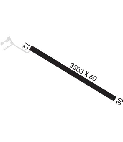
Runway Identifications
Runway Identification: 12/30
Length: 3503 ft
Width: 60 ft
Surface: CONCRETE-FAIR CONDITION
Edge lights: Medium Intensity

Treatment: NONE
Weight: PCN 6 /R/D/W/U

 Runway: 12   Runway: 30
Mag heading: 115°Mag heading: 295°
Rwy Slope: -.03% DownRwy Slope: .03% Up
Approach: Approach:
Pattern: Left TrafficPattern: Left Traffic
Markings: BASICMarkings: BASIC
Marking Condition: FAIRMarking Condition: FAIR
Arresting Dev: Arresting Dev:
Lat & Long: N4223.4  W09437.5Lat. & Long.: N4223.1  W09436.8
Elev: 1215.9 ft. MSLElev: 1214.9 ft. MSL
TCH: TCH:
Visual Glide Path: Visual Glide Path:
Displaced Threshold: 1205 feetDisplaced Threshold: No
Touchdown Zone: NOTouchdown Zone: NO
Touchdown Elev.: Touchdown Elev.:
Visual Glide Slope: Visual Glide Slope:
RVR Equipment: RVR Equipment:
RVV Equipment: NORVV Equipment: NO
Approach Lights: Approach Lights:
REIL: NOREIL: NO
Centerline Lights: NOCenterline Lights: NO
Touchdown lights: NOTouchdown lights: NO
Runway Category: Runway with a Visual ApproachRunway Category: Runway with a Visual Approach
Declared Distances: TORA:3500' TODA:3500' ASDA:3500' LDA:2300'Declared Distances: TORA:3500' TODA:3500' ASDA:3500' LDA:3500'
Obstructions: POLEObstructions: TREE
Marked: NOT Marked/LightedMarked: NOT Marked/Lighted
Clearance slope: 10:1; APCH RATIO 50:1 FM DSPLCD THR.Clearance slope: 6:1
Obstruction height: 16 feet AGLObstruction height: 66 feet AGL
Dist. from runway: 372 feetDist. from runway: 633 feet
Centerline offset: 82 right of centerlineCenterline offset: 120 feet left of centerline
Comments: Comments:
C:/P: