Click here for more info on on SMS!

K2W5

MARYLAND
INDIAN HEAD
MD
Time Zone: Eastern
Lat: N 3835.8
Long: W 07704.3
Elev: 175
Var: +09
Longest Runway: 3740
CTAF: 122.7

FBO & Flight Services info for K2W5

FBOs: Update your Fuel Prices
Providing high quality fuel and services to you and your customers, from Phillips 66 Aviation.
Ph: 301-283-6202
-
Freq: 122.7WebsiteE-Mail
Service
Jet
100LL
SAF
MoGas
Full6.856.55    Last Update: 04/23/2024 13:37

Self        
Misc. Info: Address: 3900 LIVINGSTON RD,   INDIAN HEAD, MD 20640

If you are an FBO, call 1-203-262-1700 to update your info or email: FltPlan.Advertising@garmin.com
Advertise your FBO on FltPlan.com

Runway & Approach Info for K2W5
Rwy
Length
Land Dist**
Approach*
  Rwy
Length
Land Dist**
Approach*
02
3740x75  3740'          
 
  
20
  3740x75  3740'          
 
 * only ILS, LOC, LDA, and SDF approaches to a specific runway are shown
** For any Declared Landing Distance Available, please see A/FD or Approach plates
Runway Weight Capability (lbs.) Help
Runway IDSingle WheelDouble WheelDouble Tandem WheelDual Double Wheel
02/20N/AN/AN/AN/A
These numbers are Advisory and are not limits.   The Airport Manager should have more accurate Weight Limits
Approach Charts
Approaches    
Current Weather/Notams
Customs Information Send updates to Support@FltPlan.com
Customs Not Available
Database effective 05/16/2024
Airport Diagram of K2W5
Airport Diagram might not be current.

Facility Name: MARYLAND
City Name: INDIAN HEAD
County: CHARLES
State abbrev: MD
State Name: MARYLAND
   
Ownership: PRIVATELY OWNED
Use: OPEN TO THE PUBLIC
Owner's Name: PSM AVIATION LLC
Address: 3900 LIVINGSTON RD,
 INDIAN HEAD, MD 20640
Owner's Phone: 301-283-6202
  
Manager's Name: SHEEL PATEL
Address: 3900 LIVINGSTON RD
 INDIAN HEAD, MD 20640
Phone: 301-283-6202
   
FAA Region: EASTERN
FAA Field Office: DCA


Sunrise / Sunset times for MARYLAND

DateSunriseSunset
04/25/24 Thursday6:1819:55
04/26/24 Friday6:1619:56
04/27/24 Saturday6:1519:57
04/28/24 Sunday6:1419:58
04/29/24 Monday6:1319:59
04/30/24 Tuesday6:1120:00
05/01/24 Wednesday6:1020:01
05/02/24 Thursday6:0920:02
05/03/24 Friday6:0820:03
05/04/24 Saturday6:0720:04
05/05/24 Sunday6:0620:05
05/06/24 Monday6:0520:06
05/07/24 Tuesday6:0320:07
05/08/24 Wednesday6:0220:08

Airport Facilities

Airport Attendance ScheduleMON-SUN 0900-1800; UNATNDD THANKSGIVING, CHRISTMAS AND NEW YEARS DAYS.
Airport Status OPERATIONAL (This Status can change at any time - please check NOTAMS)
Airport Lighting ScheduleACTVT REIL RWY 02; PAPI RWY 02; MIRL RWY 02/20 - CTAF. ARPT DEACTIVATES PAPI RWY 02 WHEN WINDS FAVOR RWY 20.
Airport Storage AvailableTie Downs
Extra Services AvailableAvionics, Flight Instruction
Wind IndicatorYES - (unlit)
Control TowerNO
CTAF Frequency122.700
Unicom Frequency122.700
Rotating Beacon ColorWG
Segmented CircleNO
Landing FeeNO

Airport Inspection Data

Airport InspectedSTATE - performed by STATE AERONAUTICAL PERSONNEL
Inspection Date09/13/2023

Airport Services

Type of Fuel AvailableGrade 100LL, JET A (freeze point -40C)
Airframe Repair ServiceMINOR
Power Plant Repair ServiceMINOR

Geographic Data

LatitudeN3835.8
LongitudeW07704.3 (ESTIMATED)
Arpt Elevation175ft (ESTIMATED)
Magnetic Variation09W
4 miles Eof INDIAN HEAD
Traffic Pattern Altitude830
Sectional ChartWASHINGTON

Aircraft Data

Operations (Reported)YearlyAvg. Daily
General Aviation Transient 15004
General Aviation Local 2000055
Air Taxi 500
Commerical 00
Commuter 00
Military 5001
Aircraft based on Field
General Aviation Singles 107
General Aviation Multi 2
Jet Aircraft 0
General Aviation Helicopters 4
Military Aircraft 0
Gliders 1
Ultralights 0

FAA Services

FSS on field NO
FSS tie-in LEESBURG
FSS Phone 1-800-WX-BRIEF
Who issues Notams DCA
Notam D service at airport YES
ARTCC Name WASHINGTON

Federal Status

Airport Certification
Aircraft Rescue & Firefighting IndexNone
Airport of EntryNo
Custom Landing RightsNo
Joint Civil/MilitaryNo
Military Landing rightsNo

Federal Agreements

NATIONAL PLAN OF INTEGRATED AIRPORT SYSTEMS (NPIAS)

Remarks

BIRDS & WILDLIFE ON & INVOF ARPT.
FOR CD CTC POTOMAC APCH AT 866-599-3874.
Airport Communications & Frequencies:
CTAF Frequency:
122.700
Unicom Frequency:
122.700
POTOMAC Primary Approach Frequencies:  
124.7 DC SFRA
338.2 DC-SFRA
Part-time Approach Frequencies:  
118.95 DC SFRA
257.2
POTOMAC Primary Departure Frequencies:  
124.7 DC SFRA
338.2 DC-SFRA
Part-time Departure Frequencies:  
118.95 DC SFRA
257.2
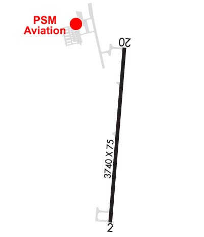
Runway Identifications
Runway Identification: 02/20
Length: 3740 ft
Width: 75 ft
Surface: ASPHALT-GOOD CONDITION
Edge lights: Medium Intensity

Treatment: NONE

 Runway: 02   Runway: 20
Mag heading: 14°Mag heading: 194°
Rwy Slope: .51% UpRwy Slope: -.51% Down
Approach: Approach:
Pattern: Left TrafficPattern: Left Traffic
Markings: NONPRECISION INSTRUMENTMarkings: BASIC
Marking Condition: GOODMarking Condition: GOOD
Arresting Dev: Arresting Dev:
Lat & Long: N3835.5  W07704.4Lat. & Long.: N3836.1  W07704.3
Elev: 156.1 ft. MSLElev: 175.0 ft. MSL
TCH: 40 ft. AGLTCH:
Visual Glide Path: 3.00 degreesVisual Glide Path:
Displaced Threshold: NoDisplaced Threshold: No
Touchdown Zone: YESTouchdown Zone: YES
Touchdown Elev.: 163.1 feetTouchdown Elev.: 169.8 feet
Visual Glide Slope: 4-Light PAPI on LEFT side of RunwayVisual Glide Slope:
RVR Equipment: RVR Equipment:
RVV Equipment: NORVV Equipment: NO
Approach Lights: Approach Lights:
REIL: YESREIL: NO
Centerline Lights: NOCenterline Lights: NO
Touchdown lights: NOTouchdown lights: NO
Runway Category: Runway with a Non-precision Approach having visibility minimums greater than 3/4 mileRunway Category: Runway with a Visual Approach
Declared Distances: Declared Distances:
Obstructions: TREESObstructions: TREES
Marked: NOT Marked/LightedMarked: NOT Marked/Lighted
Clearance slope: 31:1Clearance slope: 22:1
Obstruction height: 65 feet AGLObstruction height: 70 feet AGL
Dist. from runway: 2240 feetDist. from runway: 1804 feet
Centerline offset: 195 left of centerlineCenterline offset: 301 feet left of centerline
Comments: Comments:
C:2/P: