Click here for more info on on SMS!

K2V5

WRAY MUNI
WRAY
CO
Time Zone: Mountain
Lat: N 4006.0
Long: W 10214.5
Elev: 3678
Var: -08
Longest Runway: 5399
AWOS: 118.25
CTAF: 122.8

FBO & Flight Services info for K2V5

FBOs: Update your Fuel Prices

TRIANGLE AVIATIONPh: 970-332-4656 Fax: N/A Freq: 122.8
Service
Jet
100LL
SAF
MoGas
Fuel Avail: PRIST PREMIXED
Full        Caution: Fuel prices have not been updated in 56 days.
Last Update: 03/02/2024 17:51

Self5.905.50    
 Address: 36395 U.S HWY 385   RAY, CO 80758
AWOSPh: 970-332-5930
-
Freq: 118.25  
If you are an FBO, call 1-203-262-1700 to update your info or email: FltPlan.Advertising@garmin.com
Advertise your FBO on FltPlan.com

Runway & Approach Info for K2V5
Rwy
Length
Land Dist**
Approach*
  Rwy
Length
Land Dist**
Approach*
17
5399x75  5399'          
 
  
35
  5399x75  5399'          
 
 * only ILS, LOC, LDA, and SDF approaches to a specific runway are shown
** For any Declared Landing Distance Available, please see A/FD or Approach plates
Runway Weight Capability (lbs.) Help
Runway IDSingle WheelDouble WheelDouble Tandem WheelDual Double Wheel
17/3516,000N/AN/AN/A
These numbers are Advisory and are not limits.   The Airport Manager should have more accurate Weight Limits
Approach Charts
Approaches    
Current Weather/Notams
Customs Information Send updates to Support@FltPlan.com
Customs Not Available
Database effective 05/16/2024
Airport Diagram of K2V5
Airport Diagram might not be current.

Facility Name: WRAY MUNI
City Name: WRAY
County: YUMA
State abbrev: CO
State Name: COLORADO
   
Ownership: PUBLICLY OWNED
Use: OPEN TO THE PUBLIC
Owner's Name: CITY OF WRAY
Address: PO BOX 35
 WRAY, CO 80758
Owner's Phone: 970-332-4431
  
Manager's Name: GREG ALLEN
Address: 36395 S HWY 385
 WRAY, CO 80758
Phone: 970-332-4656
   
FAA Region: NORTHWEST MOUNTAIN
FAA Field Office: DEN


Sunrise / Sunset times for WRAY MUNI

DateSunriseSunset
04/26/24 Friday5:5419:40
04/27/24 Saturday5:5319:41
04/28/24 Sunday5:5219:42
04/29/24 Monday5:5019:43
04/30/24 Tuesday5:4919:44
05/01/24 Wednesday5:4819:45
05/02/24 Thursday5:4719:46
05/03/24 Friday5:4519:47
05/04/24 Saturday5:4419:48
05/05/24 Sunday5:4319:49
05/06/24 Monday5:4219:50
05/07/24 Tuesday5:4119:51
05/08/24 Wednesday5:4019:52
05/09/24 Thursday5:3919:53

Airport Facilities

Airport Attendance ScheduleMON-FRI 0800-1700, SAT 0800-1200
Airport Status OPERATIONAL (This Status can change at any time - please check NOTAMS)
Airport Lighting ScheduleACTVT REIL RWY 17 & 35; PAPI RWY 17 & 35; MIRL RWY 17/35 - CTAF.
Airport Storage AvailableTie Downs
Extra Services AvailableCrop Dusting, Air Ambulance, Flight Instruction
Wind IndicatorYES - (lighted)
Control TowerNO
CTAF Frequency122.800
Unicom Frequency122.800
Rotating Beacon ColorWG
Segmented CircleNO
Landing FeeNO

Airport Inspection Data

Airport InspectedSTATE - performed by STATE AERONAUTICAL PERSONNEL
Inspection Date06/14/2023

Airport Services

Type of Fuel AvailableGrade 100LL
Airframe Repair ServiceNone
Power Plant Repair ServiceNone

Geographic Data

LatitudeN4006.0
LongitudeW10214.5 (ESTIMATED)
Arpt Elevation3677ft (SURVEYED)
Magnetic Variation08E
2 miles NWof WRAY
Traffic Pattern Altitude
Sectional ChartCHEYENNE

Aircraft Data

Operations (Reported)YearlyAvg. Daily
General Aviation Transient 773821
General Aviation Local 686219
Air Taxi 00
Commerical 00
Commuter 00
Military 00
Aircraft based on Field
General Aviation Singles 24
General Aviation Multi 1
Jet Aircraft 0
General Aviation Helicopters 0
Military Aircraft 0
Gliders 0
Ultralights 0

FAA Services

FSS on field NO
FSS tie-in DENVER
FSS Phone 1-800-WX-BRIEF
Who issues Notams DEN
Notam D service at airport YES
ARTCC Name DENVER

Federal Status

Airport Certification
Aircraft Rescue & Firefighting IndexNone
Airport of EntryNo
Custom Landing RightsNo
Joint Civil/MilitaryNo
Military Landing rightsYES

Federal Agreements

NATIONAL PLAN OF INTEGRATED AIRPORT SYSTEMS (NPIAS)
GRANT AGREEMENTS UNDER FAAP/ADAP/AIP
ASSURANCES PURSUANT TO TITLE VI, CIVIL RIGHTS ACT OF 1964

Remarks

TWY MKD WITH BLUE REFLECTORS
24 HOUR SELF SERVE FUEL AVAILABLE.
BE ALERT; INTENSIVE USAF STUDENT TRAINING IN VICINITY OF COLORADO SPRINGS & PUEBLO COLORADO.
FOR CD CTC DENVER ARTCC AT 303-651-4257.
Airport Communications & Frequencies:
CTAF Frequency:
122.800
Unicom Frequency:
122.800
Remarks
  • APCH/DEP CTL SVC PRVDD BY DENVER ARTCC (ZDV) ON FREQS. 132.7/226.675 (OGALLALA RCAG.)
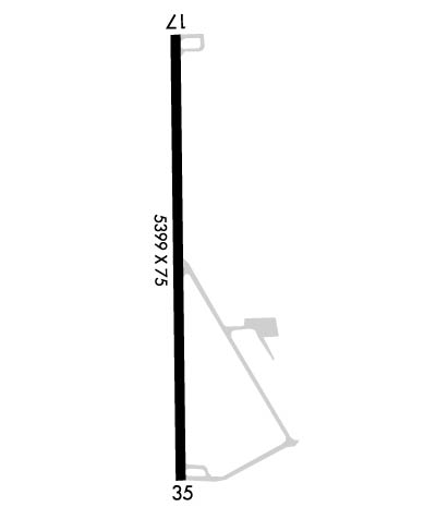
  • Runway Identifications
    Runway Identification: 17/35
    Length: 5399 ft
    Width: 75 ft
    Surface: ASPHALT-GOOD CONDITION
    Edge lights: Medium Intensity

    Treatment: NONE
    Weight: PCN 15 /F/A/Z/T

     Runway: 17   Runway: 35
    Mag heading: 172°Mag heading: 352°
    Rwy Slope: -.74% DownRwy Slope: .74% Up
    Approach: Approach:
    Pattern: Left TrafficPattern: Left Traffic
    Markings: NONPRECISION INSTRUMENTMarkings: NONPRECISION INSTRUMENT
    Marking Condition: GOODMarking Condition: GOOD
    Arresting Dev: Arresting Dev:
    Lat & Long: N4006.5  W10214.5Lat. & Long.: N4005.6  W10214.5
    Elev: 3677.6 ft. MSLElev: 3637.7 ft. MSL
    TCH: 45 ft. AGLTCH: 43 ft. AGL
    Visual Glide Path: 3.00 degreesVisual Glide Path: 3.00 degrees
    Displaced Threshold: NoDisplaced Threshold: No
    Touchdown Zone: YESTouchdown Zone: YES
    Touchdown Elev.: 3677.6 feetTouchdown Elev.: 3653.8 feet
    Visual Glide Slope: 2-Light PAPI on LEFT side of RunwayVisual Glide Slope: 2-Light PAPI on LEFT side of Runway
    RVR Equipment: RVR Equipment:
    RVV Equipment: NORVV Equipment: NO
    Approach Lights: Approach Lights:
    REIL: YESREIL: YES
    Centerline Lights: NOCenterline Lights: NO
    Touchdown lights: NOTouchdown lights: NO
    Runway Category: Runway with a Non-precision Approach having visibility minimums greater than 3/4 mileRunway Category: Runway with a Non-precision Approach having visibility minimums greater than 3/4 mile
    Declared Distances: Declared Distances:
    Obstructions: Obstructions: TREE
    Marked: Marked: NOT Marked/Lighted
    Clearance slope: 50:1Clearance slope: 13:1
    Obstruction height: Obstruction height: 16 feet AGL
    Dist. from runway: Dist. from runway: 413 feet
    Centerline offset: Centerline offset: 58 feet right of centerline
    Comments: Comments:
    C:2/P: