Approach Charts
| FltPlan does not have IFR approach charts available for K2S9. |
Current Weather/Notams (Metars, TAFs, Notams, NWS Forecast, PIREPS, and nearby weather)
Customs Information Send updates to Support@FltPlan.com
Customs Not Available
Database effective 05/16/2024
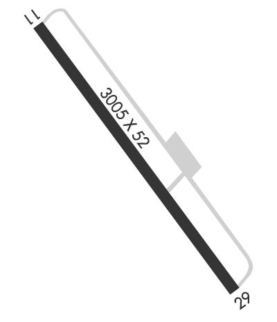
Airport Diagram might not be current.
|
| Facility Name: | WILLAPA HARBOR |
| City Name: | SOUTH BEND/RAYMOND/ |
| County: | PACIFIC |
| State abbrev: | WA |
| State Name: | WASHINGTON |
| | |
| Ownership: | PUBLICLY OWNED |
| Use: | OPEN TO THE PUBLIC |
| Owner's Name: | PORT OF WILLAPA HARBOR |
| Address: | 1725 OCEAN AVENUE |
| | RAYMOND, WA 98577 |
| Owner's Phone: | 360-942-3422 |
| | |
| Manager's Name: | JAMES SAYCE |
| Address: | PORT OF WILLAPA HARBOR, 1725 OCEAN AVENUE |
| | RAYMOND, WA 98577 |
| Phone: | 360-942-3422; EMERG CTC 360-942-7294. |
| | |
| FAA Region: | NORTHWEST MOUNTAIN |
| FAA Field Office: | SEA |
Runway Identifications
Runway Identification: 11/29Length: 3005 ft
Width: 52 ft
Surface: ASPHALT-GOOD CONDITION
Edge lights: Medium IntensityTreatment: NONE
| | Runway: 11 | | Runway: 29 |
| Mag heading: | N/A | Mag heading: | N/A |
| Approach: | | Approach: | |
| Pattern: | Left Traffic | Pattern: | Left Traffic |
| Markings: | NONPRECISION INSTRUMENT | Markings: | NONPRECISION INSTRUMENT |
| Marking Condition: | FAIR | Marking Condition: | FAIR |
| Arresting Dev: | | Arresting Dev: | |
| Lat & Long: | N4642.0 W12349.7 | Lat. & Long.: | N4641.7 W12349.1 |
| Elev: | N/A | Elev: | N/A |
| TCH: | | TCH: | |
| Visual Glide Path: | | Visual Glide Path: | |
| Displaced Threshold: | No | Displaced Threshold: | No |
| Touchdown Zone: | NO | Touchdown Zone: | NO |
| Touchdown Elev.: | | Touchdown Elev.: | |
| Visual Glide Slope: | | Visual Glide Slope: | |
| RVR Equipment: | | RVR Equipment: | |
| RVV Equipment: | NO | RVV Equipment: | NO |
| Approach Lights: | | Approach Lights: | |
| REIL: | NO | REIL: | NO |
| Centerline Lights: | NO | Centerline Lights: | NO |
| Touchdown lights: | NO | Touchdown lights: | NO |
| Runway Category: | Runway with a Visual Approach | Runway Category: | Runway with a Visual Approach |
| Declared Distances: | | Declared Distances: | |
| Obstructions: | TREES | Obstructions: | TREES |
| Marked: | NOT Marked/Lighted | Marked: | NOT Marked/Lighted |
| Clearance slope: | 22:1 | Clearance slope: | 19:1 |
| Obstruction height: | 37 feet AGL | Obstruction height: | 39 feet AGL |
| Dist. from runway: | 1045 feet | Dist. from runway: | 942 feet |
| Centerline offset: | | Centerline offset: | 125 feet right of centerline |
| Comments: | | Comments: | |

