Current Weather/Notams (Metars, TAFs, Notams, NWS Forecast, PIREPS, and nearby weather)
Customs Information Send updates to Support@FltPlan.com
Customs Not Available
Database effective 05/16/2024
Airport Diagram might not be current.
|
| Facility Name: | KENEDY RGNL |
| City Name: | KENEDY |
| County: | KARNES |
| State abbrev: | TX |
| State Name: | TEXAS |
| | |
| Ownership: | PUBLICLY OWNED |
| Use: | OPEN TO THE PUBLIC |
| Owner's Name: | CITY OF KENEDY |
| Address: | 303 W.MAIN |
| | KENEDY, TX 78119 |
| Owner's Phone: | 830-583-2230 |
| | |
| Manager's Name: | RON HYDE |
| Address: | P.O. BOX 569 |
| | KENEDY, TX 78119 |
| Phone: | (830) 583-5930 |
| | |
| FAA Region: | SOUTHWEST |
| FAA Field Office: | TEX |
Runway Identifications
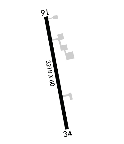
Runway Identification: 16/34Length: 3218 ft
Width: 60 ft
Surface: ASPHALT
Edge lights: Medium IntensityTreatment: NONE
| | Runway: 16 | | Runway: 34 |
| Mag heading: | 164° | Mag heading: | 344° |
| Rwy Slope: | -.51% Down | Rwy Slope: | .51% Up |
| Approach: | | Approach: | |
| Pattern: | Right Traffic | Pattern: | Left Traffic |
| Markings: | NONPRECISION INSTRUMENT | Markings: | NONPRECISION INSTRUMENT |
| Marking Condition: | GOOD | Marking Condition: | GOOD |
| Arresting Dev: | | Arresting Dev: | |
| Lat & Long: | N2849.8 W09752.0 | Lat. & Long.: | N2849.2 W09751.9 |
| Elev: | 288.7 ft. MSL | Elev: | 272.2 ft. MSL |
| TCH: | 44 ft. AGL | TCH: | 48 ft. AGL |
| Visual Glide Path: | 3.00 degrees | Visual Glide Path: | 3.60 degrees |
| Displaced Threshold: | No | Displaced Threshold: | No |
| Touchdown Zone: | YES | Touchdown Zone: | YES |
| Touchdown Elev.: | 288.7 feet | Touchdown Elev.: | 288.1 feet |
| Visual Glide Slope: | 2-Light PAPI on LEFT side of Runway | Visual Glide Slope: | 2-Light PAPI on LEFT side of Runway; RSTRD 7 DEGS LEFT DUE TO OBSTS. |
| RVR Equipment: | | RVR Equipment: | |
| RVV Equipment: | NO | RVV Equipment: | NO |
| Approach Lights: | | Approach Lights: | |
| REIL: | YES | REIL: | NO |
| Centerline Lights: | NO | Centerline Lights: | NO |
| Touchdown lights: | NO | Touchdown lights: | NO |
| Runway Category: | Runway with a Non-precision Approach | Runway Category: | Runway with a Non-precision Approach |
| Declared Distances: | | Declared Distances: | |
| Obstructions: | SIGN | Obstructions: | TREES |
| Marked: | NOT Marked/Lighted | Marked: | NOT Marked/Lighted |
| Clearance slope: | 20:1 | Clearance slope: | |
| Obstruction height: | 55 feet AGL | Obstruction height: | 12 feet AGL |
| Dist. from runway: | 1347 feet | Dist. from runway: | 201 feet |
| Centerline offset: | 77 left of centerline | Centerline offset: | 105 feet left of centerline |
| Comments: | 8 FT FENCE, 30-199 FT DSTC, 202 FT R. | Comments: | 8FT FENCE 0-199 DSTC. |

