Approach Charts
| FltPlan does not have IFR approach charts available for K2R7. |
Current Weather/Notams (Metars, TAFs, Notams, NWS Forecast, PIREPS, and nearby weather)
Customs Information Send updates to Support@FltPlan.com
Customs Not Available
Database effective 05/16/2024
Airport Diagram might not be current.
|
| Facility Name: | FRANKLINTON |
| City Name: | FRANKLINTON |
| County: | WASHINGTON |
| State abbrev: | LA |
| State Name: | LOUISIANA |
| | |
| Ownership: | PUBLICLY OWNED |
| Use: | OPEN TO THE PUBLIC |
| Owner's Name: | TOWN OF FRANKLINTON |
| Address: | 301 11TH AVE |
| | FRANKLINTON, LA 70438 |
| Owner's Phone: | 985-839-3569 |
| | |
| Manager's Name: | MARTY ROBERTS |
| Address: | 26469 OLD LAKE ROAD |
| | MOUNT HERMON, LA 70450 |
| Phone: | (225) 333-1579 |
| | |
| FAA Region: | SOUTHWEST |
| FAA Field Office: | LNM |
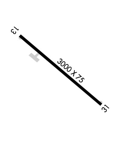
Runway Identifications
Runway Identification: 13/31Length: 3000 ft
Width: 75 ft
Surface: ASPHALT-GOOD CONDITION
Edge lights: Medium IntensityTreatment: NONE
| | Runway: 13 | | Runway: 31 |
| Mag heading: | 128° | Mag heading: | 308° |
| Rwy Slope: | .07% Up | Rwy Slope: | -.07% Down |
| Approach: | | Approach: | |
| Pattern: | Left Traffic | Pattern: | Left Traffic |
| Markings: | NONPRECISION INSTRUMENT | Markings: | NONPRECISION INSTRUMENT |
| Marking Condition: | POOR; RWY MARKINGS CHIPPED AND FADED | Marking Condition: | POOR; RUNWAY MARKINGS CHIPPED AND FADED |
| Arresting Dev: | | Arresting Dev: | |
| Lat & Long: | N3049.3 W09007.0 | Lat. & Long.: | N3049.0 W09006.5 |
| Elev: | 172.0 ft. MSL | Elev: | 174.0 ft. MSL |
| TCH: | 50 ft. AGL | TCH: | 50 ft. AGL |
| Visual Glide Path: | 3.00 degrees | Visual Glide Path: | 3.00 degrees |
| Displaced Threshold: | No | Displaced Threshold: | No |
| Touchdown Zone: | NO | Touchdown Zone: | NO |
| Touchdown Elev.: | | Touchdown Elev.: | |
| Visual Glide Slope: | 2-Light PAPI on LEFT side of Runway; RY 13 PAPI OTS INDEFLY. | Visual Glide Slope: | 2-Light PAPI on LEFT side of Runway; RY 31 PAPI OTS INDEFLY. |
| RVR Equipment: | | RVR Equipment: | |
| RVV Equipment: | NO | RVV Equipment: | NO |
| Approach Lights: | | Approach Lights: | |
| REIL: | YES; RWY 13 REILS OTS. | REIL: | YES; RWY 31 REILS OTS. |
| Centerline Lights: | NO | Centerline Lights: | NO |
| Touchdown lights: | NO | Touchdown lights: | NO |
| Runway Category: | Runway with a Visual Approach | Runway Category: | Runway with a Visual Approach |
| Declared Distances: | | Declared Distances: | |
| Obstructions: | TREES | Obstructions: | TREES |
| Marked: | NOT Marked/Lighted | Marked: | NOT Marked/Lighted |
| Clearance slope: | 11:1 | Clearance slope: | 9:1 |
| Obstruction height: | 76 feet AGL | Obstruction height: | 73 feet AGL |
| Dist. from runway: | 1069 feet | Dist. from runway: | 901 feet |
| Centerline offset: | 185 right of centerline | Centerline offset: | 171 feet right of centerline |
| Comments: | | Comments: | |

