Click here for more info on on SMS!

K2O6

CHOWCHILLA
CHOWCHILLA
CA
Time Zone: Pacific
Lat: N 3706.8
Long: W 12014.8
Elev: 243
Var: -15
Longest Runway: 3253
CTAF: 122.9

FBO & Flight Services info for K2O6

FBOs: Update your Fuel Prices

CITY OF CHOWCHILLPh: 559-665-8615
-
Freq: 122.9
Service
Jet
100LL
SAF
MoGas
Fuel Avail: NO FUEL AVAILABLE
Full        Last Update: 04/16/2024 05:50:18

Self        
If you are an FBO, call 1-203-262-1700 to update your info or email: FltPlan.Advertising@garmin.com
Advertise your FBO on FltPlan.com

Runway & Approach Info for K2O6
Rwy
Length
Land Dist**
Approach*
  Rwy
Length
Land Dist**
Approach*
12
3253x60  3253'          
 
  
30
  3253x60  3253'          
 
 * only ILS, LOC, LDA, and SDF approaches to a specific runway are shown
** For any Declared Landing Distance Available, please see A/FD or Approach plates
Runway Weight Capability (lbs.) Help
Runway IDSingle WheelDouble WheelDouble Tandem WheelDual Double Wheel
12/3012,000N/AN/AN/A
These numbers are Advisory and are not limits.   The Airport Manager should have more accurate Weight Limits
Approach Charts
FltPlan does not have IFR approach charts available for K2O6.
Current Weather/Notams
Customs Information Send updates to Support@FltPlan.com
Customs Not Available
Database effective 04/18/2024
Airport Diagram of K2O6
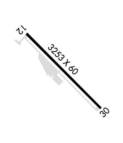
Airport Diagram might not be current.

Facility Name: CHOWCHILLA
City Name: CHOWCHILLA
County: MADERA
State abbrev: CA
State Name: CALIFORNIA
   
Ownership: PUBLICLY OWNED
Use: OPEN TO THE PUBLIC
Owner's Name: CITY OF CHOWCHILLA
Address: 130 SOUTH 2ND STREET
 CHOWCHILLA, CA 93610
Owner's Phone: 559-665-8615
  
Manager's Name: JASON ROGERS
Address: 130 SOUTH 2ND STREET
 CHOWCHILLA, CA 93610
Phone: (559) 267-3157; EXT 300
   
FAA Region: WESTERN-PACIFIC
FAA Field Office: SFO


Sunrise / Sunset times for CHOWCHILLA

DateSunriseSunset
04/15/24 Monday6:2519:37
04/16/24 Tuesday6:2419:38
04/17/24 Wednesday6:2319:39
04/18/24 Thursday6:2119:39
04/19/24 Friday6:2019:40
04/20/24 Saturday6:1919:41
04/21/24 Sunday6:1819:42
04/22/24 Monday6:1619:43
04/23/24 Tuesday6:1519:44
04/24/24 Wednesday6:1419:45
04/25/24 Thursday6:1319:46
04/26/24 Friday6:1119:47
04/27/24 Saturday6:1019:47
04/28/24 Sunday6:0919:48

Airport Facilities

Airport Attendance ScheduleUNATTENDED
Airport Status OPERATIONAL (This Status can change at any time - please check NOTAMS)
Airport Lighting ScheduleACTVT MIRL RY 12/30 - CTAF.
Airport Storage AvailableTie Downs
Extra Services AvailableCrop Dusting
Wind IndicatorYES - (lighted)
Control TowerNO
CTAF Frequency122.900
Unicom Frequency
Rotating Beacon Color
Segmented CircleYES
Landing FeeNO

Airport Inspection Data

Airport InspectedSTATE - performed by STATE AERONAUTICAL PERSONNEL
Inspection Date06/22/2023

Airport Services

Type of Fuel AvailableNone
Airframe Repair ServiceNone
Power Plant Repair ServiceNone

Geographic Data

LatitudeN3706.8
LongitudeW12014.8 (ESTIMATED)
Arpt Elevation243ft (ESTIMATED)
Magnetic Variation15E
1 miles SEof CHOWCHILLA
Traffic Pattern Altitude
Sectional ChartSAN FRANCISCO

Aircraft Data

Operations (Reported)YearlyAvg. Daily
General Aviation Transient 20005
General Aviation Local 470013
Air Taxi 00
Commerical 00
Commuter 00
Military 00
Aircraft based on Field
General Aviation Singles 16
General Aviation Multi 1
Jet Aircraft 0
General Aviation Helicopters 1
Military Aircraft 0
Gliders 0
Ultralights 0

FAA Services

FSS on field NO
FSS tie-in RANCHO MURIETA
FSS Phone 1-800-WX-BRIEF
Who issues Notams RIU
Notam D service at airport YES
ARTCC Name OAKLAND

Federal Status

Airport Certification
Aircraft Rescue & Firefighting IndexNone
Airport of EntryNo
Custom Landing RightsNo
Joint Civil/MilitaryNo
Military Landing rightsYES

Federal Agreements

NATIONAL PLAN OF INTEGRATED AIRPORT SYSTEMS (NPIAS)
GRANT AGREEMENTS UNDER FAAP/ADAP/AIP
ASSURANCES PURSUANT TO TITLE VI, CIVIL RIGHTS ACT OF 1964

Remarks

APCH TO RWY 12 +35' POWERLINES 1150' FM THR ON EXTNDD RY CNTRLN.
FOR CD CTC NORCAL APCH AT 916-361-0516.
RWY 12/3 0 300 FT STOPWAYS AT BOTH ENDS OF RY.
Runway Identifications
Runway Identification: 12/30
Length: 3253 ft
Width: 60 ft
Surface: ASPHALT-FAIR CONDITION
Edge lights: Medium Intensity

Treatment: NONE

 Runway: 12   Runway: 30
Mag heading: 119°Mag heading: 299°
Rwy Slope: .15% UpRwy Slope: -.15% Down
Approach: Approach:
Pattern: Left TrafficPattern: Right Traffic
Markings: BASICMarkings: BASIC
Marking Condition: FAIRMarking Condition: FAIR
Arresting Dev: Arresting Dev:
Lat & Long: N3707.0  W12015.1Lat. & Long.: N3706.6  W12014.6
Elev: 238.2 ft. MSLElev: 243.0 ft. MSL
TCH: TCH:
Visual Glide Path: Visual Glide Path:
Displaced Threshold: NoDisplaced Threshold: No
Touchdown Zone: YESTouchdown Zone: YES
Touchdown Elev.: 242.4 feetTouchdown Elev.: 243.0 feet
Visual Glide Slope: Visual Glide Slope:
RVR Equipment: RVR Equipment:
RVV Equipment: NORVV Equipment: NO
Approach Lights: Approach Lights:
REIL: NOREIL: NO
Centerline Lights: NOCenterline Lights: NO
Touchdown lights: NOTouchdown lights: NO
Runway Category: Runway with a Visual ApproachRunway Category: Runway with a Visual Approach
Declared Distances: Declared Distances:
Obstructions: ANTObstructions: RR
Marked: NOT Marked/LightedMarked: NOT Marked/Lighted
Clearance slope: 21:1Clearance slope: 22:1
Obstruction height: 60 feet AGLObstruction height: 24 feet AGL
Dist. from runway: 1500 feetDist. from runway: 750 feet
Centerline offset: 100 right of centerlineCenterline offset:
Comments: Comments:
C:/P: