Approach Charts
| FltPlan does not have IFR approach charts available for K2O3. |
Current Weather/Notams (Metars, TAFs, Notams, NWS Forecast, PIREPS, and nearby weather)
Customs Information Send updates to Support@FltPlan.com
Customs Not Available
Database effective 05/16/2024
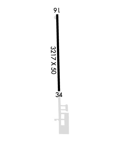
Airport Diagram might not be current.
|
| Facility Name: | ANGWIN-PARRETT FLD |
| City Name: | ANGWIN |
| County: | NAPA |
| State abbrev: | CA |
| State Name: | CALIFORNIA |
| | |
| Ownership: | PRIVATELY OWNED |
| Use: | OPEN TO THE PUBLIC |
| Owner's Name: | PACIFIC UNION COLLEGE |
| Address: | 1 ANGWIN AVENUE |
| | ANGWIN, CA 94508 |
| Owner's Phone: | 707-965-6219 |
| | |
| Manager's Name: | KEUNSANG CHO |
| Address: | 1 ANGWIN AVENUE |
| | ANGWIN, CA 94508 |
| Phone: | 707-965-6219 |
| | |
| FAA Region: | WESTERN-PACIFIC |
| FAA Field Office: | SFO |
Runway Identifications
Runway Identification: 16/34Length: 3217 ft
Width: 50 ft
Surface: ASPHALT-FAIR CONDITION
Edge lights: Low IntensityTreatment: NONE
| | Runway: 16 | | Runway: 34 |
| Mag heading: | N/A | Mag heading: | N/A |
| Rwy Slope: | -1.06% Down | Rwy Slope: | 1.06% Up |
| Approach: | | Approach: | |
| Pattern: | Left Traffic | Pattern: | Right Traffic |
| Markings: | BASIC | Markings: | BASIC |
| Marking Condition: | GOOD | Marking Condition: | GOOD |
| Arresting Dev: | | Arresting Dev: | |
| Lat & Long: | N3835.1 W12226.2 | Lat. & Long.: | N3834.5 W12226.1 |
| Elev: | 1875.0 ft. MSL | Elev: | 1841.0 ft. MSL |
| TCH: | 18 ft. AGL | TCH: | 18 ft. AGL |
| Visual Glide Path: | 5.00 degrees | Visual Glide Path: | 5.00 degrees |
| Displaced Threshold: | No | Displaced Threshold: | No |
| Touchdown Zone: | NO | Touchdown Zone: | NO |
| Touchdown Elev.: | | Touchdown Elev.: | |
| Visual Glide Slope: | 2-Light PAPI on LEFT side of Runway | Visual Glide Slope: | 2-Light PAPI on LEFT side of Runway |
| RVR Equipment: | | RVR Equipment: | |
| RVV Equipment: | NO | RVV Equipment: | NO |
| Approach Lights: | | Approach Lights: | |
| REIL: | NO | REIL: | NO |
| Centerline Lights: | NO | Centerline Lights: | NO |
| Touchdown lights: | NO | Touchdown lights: | NO |
| Runway Category: | Runway with a Visual Approach | Runway Category: | Runway with a Visual Approach |
| Declared Distances: | | Declared Distances: | |
| Obstructions: | TREE | Obstructions: | TREES |
| Marked: | NOT Marked/Lighted | Marked: | NOT Marked/Lighted |
| Clearance slope: | 16:1 | Clearance slope: | 19:1 |
| Obstruction height: | 50 feet AGL | Obstruction height: | 100 feet AGL |
| Dist. from runway: | 1000 feet | Dist. from runway: | 2100 feet |
| Centerline offset: | 210 left of centerline | Centerline offset: | 330 feet right of centerline |
| Comments: | | Comments: | |

