Current Weather/Notams (Metars, TAFs, Notams, NWS Forecast, PIREPS, and nearby weather)
Customs Information Send updates to Support@FltPlan.com
Customs Not Available
Database effective 04/18/2024
Airport Diagram might not be current.
|
| Facility Name: | CHARLES W BAKER |
| City Name: | MILLINGTON |
| County: | SHELBY |
| State abbrev: | TN |
| State Name: | TENNESSEE |
| | |
| Ownership: | PUBLICLY OWNED |
| Use: | OPEN TO THE PUBLIC |
| Owner's Name: | MEMPHIS SHELBY CO ARPT AUTH |
| Address: | 2491 WINCHESTER ROAD, SUITE 113 |
| | MEMPHIS, TN 38116-3856 |
| Owner's Phone: | 901-922-8000 |
| | |
| Manager's Name: | JASON MCBRIDE |
| Address: | 2787 NORTH SECOND STREET |
| | MEMPHIS, TN 38127 |
| Phone: | 901-358-0028 |
| | |
| FAA Region: | SOUTHERN |
| FAA Field Office: | MEM |
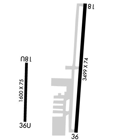
Runway Identifications
Runway Identification: 18/36Length: 3499 ft
Width: 75 ft
Surface: ASPHALT-GOOD CONDITION
Edge lights: Medium IntensityTreatment: NONE
| | Runway: 18 | | Runway: 36 |
| Mag heading: | 185° | Mag heading: | 5° |
| Rwy Slope: | -.13% Down | Rwy Slope: | .13% Up |
| Approach: | | Approach: | |
| Pattern: | Left Traffic | Pattern: | Right Traffic |
| Markings: | NONPRECISION INSTRUMENT | Markings: | NONPRECISION INSTRUMENT |
| Marking Condition: | FAIR | Marking Condition: | FAIR |
| Arresting Dev: | | Arresting Dev: | |
| Lat & Long: | N3517.0 W08955.9 | Lat. & Long.: | N3516.5 W08955.9 |
| Elev: | 246.8 ft. MSL | Elev: | 242.3 ft. MSL |
| TCH: | 40 ft. AGL | TCH: | 40 ft. AGL |
| Visual Glide Path: | 4.00 degrees | Visual Glide Path: | 4.00 degrees |
| Displaced Threshold: | No | Displaced Threshold: | No |
| Touchdown Zone: | YES | Touchdown Zone: | YES |
| Touchdown Elev.: | 246.8 feet | Touchdown Elev.: | 246.2 feet |
| Visual Glide Slope: | 2-Light PAPI on LEFT side of Runway | Visual Glide Slope: | 2-Light PAPI on LEFT side of Runway |
| RVR Equipment: | | RVR Equipment: | |
| RVV Equipment: | NO | RVV Equipment: | NO |
| Approach Lights: | | Approach Lights: | |
| REIL: | YES | REIL: | YES |
| Centerline Lights: | NO | Centerline Lights: | NO |
| Touchdown lights: | NO | Touchdown lights: | NO |
| Runway Category: | Runway with a Non-precision Approach | Runway Category: | Runway with a Non-precision Approach |
| Declared Distances: | | Declared Distances: | |
| Obstructions: | TREE | Obstructions: | TREE |
| Marked: | NOT Marked/Lighted | Marked: | NOT Marked/Lighted |
| Clearance slope: | 15:1 | Clearance slope: | 16:1 |
| Obstruction height: | 76 feet AGL | Obstruction height: | 45 feet AGL |
| Dist. from runway: | 1378 feet | Dist. from runway: | 956 feet |
| Centerline offset: | 1376 right of centerline | Centerline offset: | 955 feet right of centerline |
| Comments: | | Comments: | |
Runway Identification: 18U/36ULength: 1600 ft
Width: 75 ft
Surface: ASPHALT-POOR CONDITION
Edge lights: Treatment: NONE
| | Runway: 18U | | Runway: 36U |
| Mag heading: | 183° | Mag heading: | 3° |
| Rwy Slope: | .06% Up | Rwy Slope: | -.06% Down |
| Approach: | | Approach: | |
| Pattern: | Left Traffic | Pattern: | Left Traffic |
| Markings: | NONSTANDARD | Markings: | NONSTANDARD |
| Marking Condition: | POOR | Marking Condition: | POOR |
| Arresting Dev: | | Arresting Dev: | |
| Lat & Long: | N3516.8 W08956.2 | Lat. & Long.: | N3516.5 W08956.2 |
| Elev: | 240.0 ft. MSL | Elev: | 241.0 ft. MSL |
| TCH: | | TCH: | |
| Visual Glide Path: | | Visual Glide Path: | |
| Displaced Threshold: | No | Displaced Threshold: | No |
| Touchdown Zone: | NO | Touchdown Zone: | NO |
| Touchdown Elev.: | | Touchdown Elev.: | |
| Visual Glide Slope: | | Visual Glide Slope: | |
| RVR Equipment: | | RVR Equipment: | |
| RVV Equipment: | NO | RVV Equipment: | NO |
| Approach Lights: | | Approach Lights: | |
| REIL: | NO | REIL: | NO |
| Centerline Lights: | NO | Centerline Lights: | NO |
| Touchdown lights: | NO | Touchdown lights: | NO |
| Runway Category: | Runway with a Visual Approach | Runway Category: | Runway with a Visual Approach |
| Declared Distances: | | Declared Distances: | |
| Obstructions: | TREE | Obstructions: | TREES |
| Marked: | NOT Marked/Lighted | Marked: | NOT Marked/Lighted; PLINE 970 FT FM RWY END; MKD WITH ORANGE BALLS. |
| Clearance slope: | 9:1 | Clearance slope: | 13:1 |
| Obstruction height: | 30 feet AGL | Obstruction height: | 96 feet AGL |
| Dist. from runway: | 475 feet | Dist. from runway: | 1500 feet |
| Centerline offset: | 87 right of centerline | Centerline offset: | 217 feet left of centerline |
| Comments: | | Comments: | |

