Click here for more info on on SMS!

K2M2

LAWRENCEBURG-LAWRENCE COUNTY
LAWRENCEBURG
TN
Time Zone: Central
Lat: N 3514.1
Long: W 08715.5
Elev: 937
Var: +01
Longest Runway: 5002
Clr Del: 121.72 (GCO)
AWOS: 120.17
CTAF: 122.8

FBO & Flight Services info for K2M2

FBOs: Update your Fuel Prices

LAWRENCE CO APTPh: 931-762-5133 Fax: 931-766-1557 Freq: 122.8
Service
Jet
100LL
SAF
MoGas
Fuel Avail: 24hr Self Serve. / Assisted fueling available 8:00 A.M. to 5:00 P.M. M-F
Full        Last Update: 04/05/2024 10:44

Self5.054.99    
 Address: 4110 AIRPORT DR   LAWRENCEBURG, TN 38464
AWOSPh: 931-766-1585
-
Freq: 120.17  
If you are an FBO, call 1-203-262-1700 to update your info or email: FltPlan.Advertising@garmin.com
Advertise your FBO on FltPlan.com

Runway & Approach Info for K2M2
Rwy
Length
Land Dist**
Approach*
  Rwy
Length
Land Dist**
Approach*
17
5002x100  5002'          
 
  
35
  5002x100  5002'          
 
 * only ILS, LOC, LDA, and SDF approaches to a specific runway are shown
** For any Declared Landing Distance Available, please see A/FD or Approach plates
Runway Weight Capability (lbs.) Help
Runway IDSingle WheelDouble WheelDouble Tandem WheelDual Double Wheel
17/3515,000N/AN/AN/A
These numbers are Advisory and are not limits.   The Airport Manager should have more accurate Weight Limits
Approach Charts
Approaches    
Current Weather/Notams
Customs Information Send updates to Support@FltPlan.com
Customs Not Available
Database effective 04/18/2024
Airport Diagram of K2M2
Airport Diagram might not be current.

Facility Name: LAWRENCEBURG-LAWRENCE COUNTY
City Name: LAWRENCEBURG
County: LAWRENCE
State abbrev: TN
State Name: TENNESSEE
   
Ownership: PUBLICLY OWNED
Use: OPEN TO THE PUBLIC
Owner's Name: CITY OF LAWRENCEBURG
Address: 233 WEST GAINES
 LAWRENCEBURG, TN 38464
Owner's Phone: 931-762-5133; 931-766-4128.
  
Manager's Name: DOUG SMITH
Address: 4110 AIRPORT DR
 LAWRENCEBURG, TN 38464
Phone: 931-762-5133
   
FAA Region: SOUTHERN
FAA Field Office: MEM


Sunrise / Sunset times for LAWRENCEBURG-LAWRENCE COUNTY

DateSunriseSunset
04/18/24 Thursday6:1219:25
04/19/24 Friday6:1119:26
04/20/24 Saturday6:1019:27
04/21/24 Sunday6:0819:27
04/22/24 Monday6:0719:28
04/23/24 Tuesday6:0619:29
04/24/24 Wednesday6:0519:30
04/25/24 Thursday6:0419:31
04/26/24 Friday6:0219:31
04/27/24 Saturday6:0119:32
04/28/24 Sunday6:0019:33
04/29/24 Monday5:5919:34
04/30/24 Tuesday5:5819:35
05/01/24 Wednesday5:5719:36

Airport Facilities

Airport Attendance Schedule7 Days A Week 0800-1700; AFT HR - 931-231-4075.
Airport Status OPERATIONAL (This Status can change at any time - please check NOTAMS)
Airport Lighting ScheduleSS-SR
Airport Storage AvailableTie Downs, Hanger
Extra Services AvailableCrop Dusting, Flight Instruction
Wind IndicatorYES - (lighted)
Control TowerNO
CTAF Frequency122.800
Unicom Frequency122.800
Rotating Beacon ColorWG
Segmented CircleYES
Landing FeeNO

Airport Inspection Data

Airport InspectedSTATE - performed by STATE AERONAUTICAL PERSONNEL
Inspection Date04/24/2023

Airport Services

Type of Fuel AvailableGrade 100LL, JET A
Airframe Repair ServiceMAJOR; BOTH ON SITE
Power Plant Repair ServiceMINOR

Geographic Data

LatitudeN3514.1
LongitudeW08715.5 (ESTIMATED)
Arpt Elevation936ft (SURVEYED)
Magnetic Variation01W
3 miles NEof LAWRENCEBURG
Traffic Pattern Altitude
Sectional ChartATLANTA

Aircraft Data

Operations (Reported)YearlyAvg. Daily
General Aviation Transient 32009
General Aviation Local 650018
Air Taxi 00
Commerical 00
Commuter 00
Military 3001
Aircraft based on Field
General Aviation Singles 27
General Aviation Multi 3
Jet Aircraft 1
General Aviation Helicopters 1
Military Aircraft 0
Gliders 0
Ultralights 0

FAA Services

FSS on field NO
FSS tie-in JACKSON
FSS Phone 1-800-WX-BRIEF
Who issues Notams MKL
Notam D service at airport YES
ARTCC Name MEMPHIS

Federal Status

Airport Certification
Aircraft Rescue & Firefighting IndexNone
Airport of EntryNo
Custom Landing RightsNo
Joint Civil/MilitaryNo
Military Landing rightsYES

Federal Agreements

NATIONAL PLAN OF INTEGRATED AIRPORT SYSTEMS (NPIAS)
GRANT AGREEMENT HAS EXPIRED; HOWEVER, AGREEMENT REMAINS IN EFFECT FOR THIS FACILITY AS LONG AS IT IS PUBLIC USE.

Remarks

FOR CD CTC MEMPHIS ARTCC AT 901-368-8453/8449.
Airport Communications & Frequencies:
CTAF Frequency:
122.800
Unicom Frequency:
122.800
Remarks
  • APCH/DEP SVC PRVDD BY MEMPHIS ARTCC ON FREQS 125.85/379.25 (CENTERVILLE RCAG).
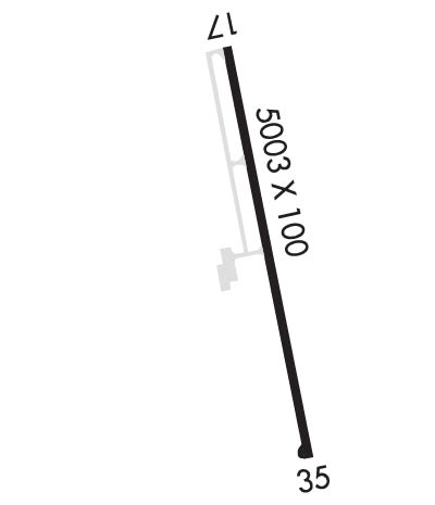
  • Runway Identifications
    Runway Identification: 17/35
    Length: 5002 ft
    Width: 100 ft
    Surface: ASPHALT-GOOD CONDITION
    Edge lights: Medium Intensity

    Treatment: NONE
    Weight: PCN 12 /F/C/X/T

     Runway: 17   Runway: 35
    Mag heading: 168°Mag heading: 348°
    Rwy Slope: -.19% DownRwy Slope: .19% Up
    Approach: Approach:
    Pattern: Left TrafficPattern: Left Traffic
    Markings: NONPRECISION INSTRUMENTMarkings: NONPRECISION INSTRUMENT
    Marking Condition: FAIRMarking Condition: FAIR
    Arresting Dev: Arresting Dev:
    Lat & Long: N3514.5  W08715.6Lat. & Long.: N3513.7  W08715.4
    Elev: 936.5 ft. MSLElev: 927.0 ft. MSL
    TCH: 50 ft. AGLTCH: 50 ft. AGL
    Visual Glide Path: 3.00 degreesVisual Glide Path: 3.00 degrees
    Displaced Threshold: NoDisplaced Threshold: No
    Touchdown Zone: YESTouchdown Zone: YES
    Touchdown Elev.: 936.5 feetTouchdown Elev.: 927.3 feet
    Visual Glide Slope: 4-Light PAPI on LEFT side of RunwayVisual Glide Slope: 4-Light PAPI on LEFT side of Runway
    RVR Equipment: RVR Equipment:
    RVV Equipment: NORVV Equipment: NO
    Approach Lights: Approach Lights:
    REIL: YESREIL: YES
    Centerline Lights: NOCenterline Lights: NO
    Touchdown lights: NOTouchdown lights: NO
    Runway Category: Runway with a Non-precision Approach having visibility minimums greater than 3/4 mileRunway Category: Runway with a Non-precision Approach having visibility minimums greater than 3/4 mile
    Declared Distances: Declared Distances:
    Obstructions: TREESObstructions: TREES
    Marked: NOT Marked/LightedMarked: NOT Marked/Lighted
    Clearance slope: 15:1Clearance slope: 24:1
    Obstruction height: 99 feet AGLObstruction height: 113 feet AGL
    Dist. from runway: 1732 feetDist. from runway: 2818 feet
    Centerline offset: 127 left of centerlineCenterline offset: 167 feet left of centerline
    Comments: Comments:
    C:2/P: