Current Weather/Notams (Metars, TAFs, Notams, NWS Forecast, PIREPS, and nearby weather)
Customs Information Send updates to Support@FltPlan.com
Customs Not Available
Database effective 05/16/2024
Airport Diagram might not be current.
|
| Facility Name: | PRINCETON-CALDWELL COUNTY |
| City Name: | PRINCETON |
| County: | CALDWELL |
| State abbrev: | KY |
| State Name: | KENTUCKY |
| | |
| Ownership: | PUBLICLY OWNED |
| Use: | OPEN TO THE PUBLIC |
| Owner's Name: | PRINCETON-CALDWELL CO ARPT BD |
| Address: | 106 MEADOWBROOK DRIVE |
| | PRINCETON, KY 42445 |
| Owner's Phone: | (270) 625-3609 |
| | |
| Manager's Name: | LLOYD MURDOCK |
| Address: | 106 MEADOWBROOK DRIVE |
| | PRINCETON, KY 42445 |
| Phone: | (270) 625-3609 |
| | |
| FAA Region: | SOUTHERN |
| FAA Field Office: | MEM |
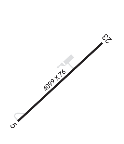
Runway Identifications
Runway Identification: 05/23Length: 4099 ft
Width: 76 ft
Surface: ASPHALT-FAIR CONDITION
Edge lights: Medium IntensityTreatment: NONE
| | Runway: 05 | | Runway: 23 |
| Mag heading: | N/A | Mag heading: | N/A |
| Rwy Slope: | -1.06% Down | Rwy Slope: | 1.06% Up |
| Approach: | | Approach: | |
| Pattern: | Left Traffic | Pattern: | Left Traffic |
| Markings: | NONPRECISION INSTRUMENT | Markings: | NONPRECISION INSTRUMENT |
| Marking Condition: | POOR; ALGAE COVERED & FADED. | Marking Condition: | POOR; ALGAE COVERED & FADED. |
| Arresting Dev: | | Arresting Dev: | |
| Lat & Long: | N3706.7 W08751.7 | Lat. & Long.: | N3707.1 W08751.1 |
| Elev: | 584.3 ft. MSL | Elev: | 541.0 ft. MSL |
| TCH: | 29 ft. AGL | TCH: | 32 ft. AGL |
| Visual Glide Path: | 3.25 degrees | Visual Glide Path: | 3.00 degrees |
| Displaced Threshold: | No | Displaced Threshold: | No |
| Touchdown Zone: | YES | Touchdown Zone: | YES |
| Touchdown Elev.: | 584.3 feet | Touchdown Elev.: | 573.1 feet |
| Visual Glide Slope: | 2-Light PAPI on LEFT side of Runway | Visual Glide Slope: | 2-Light PAPI on LEFT side of Runway |
| RVR Equipment: | | RVR Equipment: | |
| RVV Equipment: | NO | RVV Equipment: | NO |
| Approach Lights: | | Approach Lights: | |
| REIL: | YES | REIL: | YES |
| Centerline Lights: | NO | Centerline Lights: | NO |
| Touchdown lights: | NO | Touchdown lights: | NO |
| Runway Category: | Runway with a Non-precision Approach | Runway Category: | Runway with a Non-precision Approach |
| Declared Distances: | | Declared Distances: | |
| Obstructions: | BERM | Obstructions: | |
| Marked: | NOT Marked/Lighted | Marked: | |
| Clearance slope: | 4:1 | Clearance slope: | 20:1 |
| Obstruction height: | 11 feet AGL | Obstruction height: | |
| Dist. from runway: | 253 feet | Dist. from runway: | |
| Centerline offset: | 253 right of centerline | Centerline offset: | |
| Comments: | +4 FT BERM 49 FT FROM RWY END, 124 FT L. | Comments: | |

