Approach Charts
| FltPlan does not have IFR approach charts available for K2L0. |
Current Weather/Notams (Metars, TAFs, Notams, NWS Forecast, PIREPS, and nearby weather)
Customs Information Send updates to Support@FltPlan.com
Customs Not Available
Database effective 05/16/2024
Airport Diagram might not be current.
|
| Facility Name: | PINEVILLE MUNI |
| City Name: | PINEVILLE |
| County: | RAPIDES |
| State abbrev: | LA |
| State Name: | LOUISIANA |
| | |
| Ownership: | PUBLICLY OWNED |
| Use: | OPEN TO THE PUBLIC |
| Owner's Name: | CITY OF PINEVILLE |
| Address: | P. O. BOX 3820 |
| | PINEVILLE, LA 71361-3820 |
| Owner's Phone: | 318-445-7163 |
| | |
| Manager's Name: | LONNIE LUCIUS |
| Address: | 200 LAKE BUHLOW RD |
| | PINEVILLE, LA 71360 |
| Phone: | 318-449-5679 |
| | |
| FAA Region: | SOUTHWEST |
| FAA Field Office: | LNM |
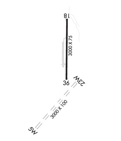
Runway Identifications
Runway Identification: 05W/23WLength: 3000 ft
Width: 100 ft
Surface: WATER
Edge lights: Treatment: NONE
| | Runway: 05W | | Runway: 23W |
| Mag heading: | N/A | Mag heading: | N/A |
| Approach: | | Approach: | |
| Pattern: | Left Traffic | Pattern: | Right Traffic |
| Markings: | | Markings: | |
| Marking Condition: | | Marking Condition: | |
| Arresting Dev: | | Arresting Dev: | |
| Lat & Long: | | Lat. & Long.: | |
| Elev: | N/A | Elev: | N/A |
| TCH: | | TCH: | |
| Visual Glide Path: | | Visual Glide Path: | |
| Displaced Threshold: | No | Displaced Threshold: | No |
| Touchdown Zone: | NO | Touchdown Zone: | NO |
| Touchdown Elev.: | | Touchdown Elev.: | |
| Visual Glide Slope: | | Visual Glide Slope: | |
| RVR Equipment: | | RVR Equipment: | |
| RVV Equipment: | NO | RVV Equipment: | NO |
| Approach Lights: | | Approach Lights: | |
| REIL: | NO | REIL: | NO |
| Centerline Lights: | NO | Centerline Lights: | NO |
| Touchdown lights: | NO | Touchdown lights: | NO |
| Runway Category: | Runway with a Visual Approach | Runway Category: | Runway with a Visual Approach |
| Declared Distances: | | Declared Distances: | |
Runway Identification: 18/36Length: 3000 ft
Width: 75 ft
Surface: ASPHALT-FAIR CONDITION
Edge lights: Medium IntensityTreatment: NONE
| | Runway: 18 | | Runway: 36 |
| Mag heading: | N/A | Mag heading: | N/A |
| Rwy Slope: | -.50% Down | Rwy Slope: | .50% Up |
| Approach: | | Approach: | |
| Pattern: | Left Traffic | Pattern: | Left Traffic |
| Markings: | NONPRECISION INSTRUMENT | Markings: | NONPRECISION INSTRUMENT |
| Marking Condition: | POOR; RWY MARKINGS FADED | Marking Condition: | POOR; RWY MARKINGS FADED |
| Arresting Dev: | | Arresting Dev: | |
| Lat & Long: | N3120.8 W09226.6 | Lat. & Long.: | N3120.3 W09226.6 |
| Elev: | 98.0 ft. MSL | Elev: | 83.0 ft. MSL |
| TCH: | 68 ft. AGL | TCH: | 49 ft. AGL |
| Visual Glide Path: | 4.00 degrees | Visual Glide Path: | 3.00 degrees |
| Displaced Threshold: | No | Displaced Threshold: | No |
| Touchdown Zone: | NO | Touchdown Zone: | NO |
| Touchdown Elev.: | | Touchdown Elev.: | |
| Visual Glide Slope: | 2-Light PAPI on LEFT side of Runway | Visual Glide Slope: | 2-Light PAPI on RIGHT side of Runway |
| RVR Equipment: | | RVR Equipment: | |
| RVV Equipment: | NO | RVV Equipment: | NO |
| Approach Lights: | | Approach Lights: | |
| REIL: | YES; REILS OUT OF SERVICE APPROACH END RWY 18 | REIL: | YES; REILS OUT OF SERVICE APPROACH END RWY 36 |
| Centerline Lights: | NO | Centerline Lights: | NO |
| Touchdown lights: | NO | Touchdown lights: | NO |
| Runway Category: | Runway with a Visual Approach | Runway Category: | Runway with a Visual Approach |
| Declared Distances: | | Declared Distances: | |
| Obstructions: | TREES | Obstructions: | TREES |
| Marked: | NOT Marked/Lighted | Marked: | NOT Marked/Lighted |
| Clearance slope: | 13:1 | Clearance slope: | 30:1 |
| Obstruction height: | 95 feet AGL | Obstruction height: | 102 feet AGL |
| Dist. from runway: | 1487 feet | Dist. from runway: | 3264 feet |
| Centerline offset: | 197 left of centerline | Centerline offset: | 170 feet left of centerline |
| Comments: | | Comments: | |

