Current Weather/Notams (Metars, TAFs, Notams, NWS Forecast, PIREPS, and nearby weather)
Customs Information Send updates to Support@FltPlan.com
Customs Not Available
Database effective 05/16/2024
Airport Diagram might not be current.
|
| Facility Name: | NEODESHA MUNI |
| City Name: | NEODESHA |
| County: | WILSON |
| State abbrev: | KS |
| State Name: | KANSAS |
| | |
| Ownership: | PUBLICLY OWNED |
| Use: | OPEN TO THE PUBLIC |
| Owner's Name: | CITY OF NEODESHA |
| Address: | PO BOX 336 |
| | NEODESHA, KS 66757 |
| Owner's Phone: | 620-325-2828 |
| | |
| Manager's Name: | JEREMY JOHNSON |
| Address: | PO BOX 336 |
| | NEODESHA, KS 66757 |
| Phone: | 620-288-9264; EVENING CALL 620-920-0348 |
| | |
| FAA Region: | CENTRAL |
| FAA Field Office: | NONE |
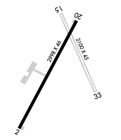
Runway Identifications
Runway Identification: 02/20Length: 2998 ft
Width: 46 ft
Surface: ASPHALT-POOR CONDITION
Edge lights: Low IntensityTreatment: NONE
| | Runway: 02 | | Runway: 20 |
| Mag heading: | 27° | Mag heading: | 207° |
| Rwy Slope: | .63% Up | Rwy Slope: | -.63% Down |
| Approach: | | Approach: | |
| Pattern: | Left Traffic | Pattern: | Left Traffic |
| Markings: | BASIC | Markings: | BASIC |
| Marking Condition: | FAIR | Marking Condition: | FAIR |
| Arresting Dev: | | Arresting Dev: | |
| Lat & Long: | N3725.9 W09539.0 | Lat. & Long.: | N3726.3 W09538.7 |
| Elev: | 822.0 ft. MSL | Elev: | 841.0 ft. MSL |
| TCH: | | TCH: | |
| Visual Glide Path: | | Visual Glide Path: | |
| Displaced Threshold: | No | Displaced Threshold: | No |
| Touchdown Zone: | YES | Touchdown Zone: | YES |
| Touchdown Elev.: | 841.0 feet | Touchdown Elev.: | 841.0 feet |
| Visual Glide Slope: | | Visual Glide Slope: | |
| RVR Equipment: | | RVR Equipment: | |
| RVV Equipment: | NO | RVV Equipment: | NO |
| Approach Lights: | | Approach Lights: | |
| REIL: | NO | REIL: | NO |
| Centerline Lights: | NO | Centerline Lights: | NO |
| Touchdown lights: | NO | Touchdown lights: | NO |
| Runway Category: | Runway with a Visual Approach | Runway Category: | Runway with a Visual Approach |
| Declared Distances: | | Declared Distances: | |
| Obstructions: | TREES | Obstructions: | |
| Marked: | NOT Marked/Lighted | Marked: | |
| Clearance slope: | 9:1 | Clearance slope: | 20:1 |
| Obstruction height: | 68 feet AGL | Obstruction height: | |
| Dist. from runway: | 823 feet | Dist. from runway: | |
| Centerline offset: | 106 right of centerline | Centerline offset: | |
| Comments: | | Comments: | + 5 FT FENCE POST 190 FT FM RWY 20; 96 FT RIGHT OF CL |
Runway Identification: 15/33Length: 2100 ft
Width: 45 ft
Surface: GRASS-GOOD CONDITION
Edge lights: Treatment: NONE
| | Runway: 15 | | Runway: 33 |
| Mag heading: | 154° | Mag heading: | 334° |
| Rwy Slope: | -.71% Down | Rwy Slope: | .71% Up |
| Approach: | | Approach: | |
| Pattern: | Left Traffic | Pattern: | Left Traffic |
| Markings: | | Markings: | |
| Marking Condition: | FAIR; WHITE BARREL MARKERS ON BOTH ENDS. | Marking Condition: | FAIR |
| Arresting Dev: | | Arresting Dev: | |
| Lat & Long: | N3726.3 W09538.8 | Lat. & Long.: | N3726.0 W09538.6 |
| Elev: | 840.0 ft. MSL | Elev: | 825.0 ft. MSL |
| TCH: | | TCH: | |
| Visual Glide Path: | | Visual Glide Path: | |
| Displaced Threshold: | No | Displaced Threshold: | No |
| Touchdown Zone: | NO | Touchdown Zone: | NO |
| Touchdown Elev.: | | Touchdown Elev.: | |
| Visual Glide Slope: | | Visual Glide Slope: | |
| RVR Equipment: | | RVR Equipment: | |
| RVV Equipment: | NO | RVV Equipment: | NO |
| Approach Lights: | | Approach Lights: | |
| REIL: | NO | REIL: | NO |
| Centerline Lights: | NO | Centerline Lights: | NO |
| Touchdown lights: | NO | Touchdown lights: | NO |
| Runway Category: | Runway with a Visual Approach | Runway Category: | Runway with a Visual Approach |
| Declared Distances: | | Declared Distances: | |
| Obstructions: | | Obstructions: | TREE |
| Marked: | | Marked: | NOT Marked/Lighted |
| Clearance slope: | 50:1 | Clearance slope: | 12:1 |
| Obstruction height: | | Obstruction height: | 35 feet AGL |
| Dist. from runway: | | Dist. from runway: | 440 feet |
| Centerline offset: | | Centerline offset: | 12 feet left of centerline |
| Comments: | | Comments: | |

