Click here for more info on on SMS!

K2J5

MILLEN
MILLEN
GA
Time Zone: Eastern
Lat: N 3253.6
Long: W 08157.9
Elev: 240
Var: +05
Longest Runway: 5001
CTAF: 122.9

FBO & Flight Services info for K2J5

FBOs: Update your Fuel Prices

AIRPORTPh: 478-982-2563 Fax: N/A Freq: 122.9
Service
Jet
100LL
SAF
MoGas
Fuel Avail: NO FUEL AVAILABLE
Full        Last Update: 04/18/2024 05:44:57

Self        
If you are an FBO, call 1-203-262-1700 to update your info or email: FltPlan.Advertising@garmin.com
Advertise your FBO on FltPlan.com

Runway & Approach Info for K2J5
Rwy
Length
Land Dist**
Approach*
  Rwy
Length
Land Dist**
Approach*
17
5001x75  5001'          
 
  
35
  5001x75  5001'          
 
 * only ILS, LOC, LDA, and SDF approaches to a specific runway are shown
** For any Declared Landing Distance Available, please see A/FD or Approach plates
Runway Weight Capability (lbs.) Help
Runway IDSingle WheelDouble WheelDouble Tandem WheelDual Double Wheel
17/3516,500N/AN/AN/A
These numbers are Advisory and are not limits.   The Airport Manager should have more accurate Weight Limits
Approach Charts
Approaches    
Current Weather/Notams
Customs Information Send updates to Support@FltPlan.com
Customs Not Available
Database effective 04/18/2024
Airport Diagram of K2J5
Airport Diagram might not be current.

Facility Name: MILLEN
City Name: MILLEN
County: JENKINS
State abbrev: GA
State Name: GEORGIA
   
Ownership: PUBLICLY OWNED
Use: OPEN TO THE PUBLIC
Owner's Name: JENKINS CO
Address: PO BOX 797
 MILLEN, GA 30442
Owner's Phone: 478-982-2563
  
Manager's Name: GRADY SAXON
Address: PO BOX 797
 MILLEN, GA 30442
Phone: (478)982-2563
   
FAA Region: SOUTHERN
FAA Field Office: ATL


Sunrise / Sunset times for MILLEN

DateSunriseSunset
04/17/24 Wednesday6:5520:00
04/18/24 Thursday6:5420:01
04/19/24 Friday6:5320:02
04/20/24 Saturday6:5120:02
04/21/24 Sunday6:5020:03
04/22/24 Monday6:4920:04
04/23/24 Tuesday6:4820:05
04/24/24 Wednesday6:4720:05
04/25/24 Thursday6:4620:06
04/26/24 Friday6:4520:07
04/27/24 Saturday6:4420:07
04/28/24 Sunday6:4320:08
04/29/24 Monday6:4220:09
04/30/24 Tuesday6:4120:10

Airport Facilities

Airport Attendance ScheduleUNATTENDED
Airport Status OPERATIONAL (This Status can change at any time - please check NOTAMS)
Airport Lighting ScheduleDUSK-2200. MIRL, REIL AND PAPI RY 17/35 OPERATES DUSK-2200; AFTER 2200 ACTVT - CTAF.
Airport Storage AvailableTie Downs
Extra Services AvailableNONE
Wind IndicatorYES - (lighted)
Control TowerNO
CTAF Frequency122.900
Unicom Frequency
Rotating Beacon ColorWG
Segmented CircleYES
Landing FeeNO

Airport Inspection Data

Airport InspectedSTATE - performed by STATE AERONAUTICAL PERSONNEL
Inspection Date03/07/2024

Airport Services

Type of Fuel AvailableGrade 100LL, JET A
Airframe Repair ServiceNONE
Power Plant Repair ServiceNONE

Geographic Data

LatitudeN3253.6
LongitudeW08157.9 (ESTIMATED)
Arpt Elevation240ft (SURVEYED)
Magnetic Variation05W
5 miles Nof MILLEN
Traffic Pattern Altitude
Sectional ChartATLANTA

Aircraft Data

Operations (Reported)YearlyAvg. Daily
General Aviation Transient 10003
General Aviation Local 10003
Air Taxi 00
Commerical 00
Commuter 00
Military 00
Aircraft based on Field
General Aviation Singles 12
General Aviation Multi 0
Jet Aircraft 0
General Aviation Helicopters 0
Military Aircraft 0
Gliders 0
Ultralights 0

FAA Services

FSS on field NO
FSS tie-in MACON
FSS Phone 1-800-WX-BRIEF
Who issues Notams MCN
Notam D service at airport YES
ARTCC Name ATLANTA

Federal Status

Airport Certification
Aircraft Rescue & Firefighting IndexNone
Airport of EntryNo
Custom Landing RightsNo
Joint Civil/MilitaryNo
Military Landing rightsYES

Federal Agreements

NATIONAL PLAN OF INTEGRATED AIRPORT SYSTEMS (NPIAS)
GRANT AGREEMENTS UNDER FAAP/ADAP/AIP
ASSURANCES PURSUANT TO TITLE VI, CIVIL RIGHTS ACT OF 1964

Remarks

DEER ON & INVOF ARPT.
FOR CD CTC ATLANTA ARTCC AT 770-210-7692.
Airport Communications & Frequencies:
CTAF Frequency:
122.900
AUGUSTA Primary Approach Frequencies:  
126.8
270.3
AUGUSTA Primary Departure Frequencies:  
126.8
270.3
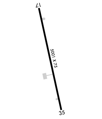
Runway Identifications
Runway Identification: 17/35
Length: 5001 ft
Width: 75 ft
Surface: ASPHALT-GOOD CONDITION
Edge lights: Medium Intensity

Treatment: NONE

 Runway: 17   Runway: 35
Mag heading: 173°Mag heading: 353°
Rwy Slope: -.38% DownRwy Slope: .38% Up
Approach: Approach:
Pattern: Right TrafficPattern: Left Traffic
Markings: NONPRECISION INSTRUMENTMarkings: NONPRECISION INSTRUMENT
Marking Condition: FAIRMarking Condition: FAIR
Arresting Dev: Arresting Dev:
Lat & Long: N3254.0  W08158.0Lat. & Long.: N3253.2  W08157.8
Elev: 240.3 ft. MSLElev: 221.2 ft. MSL
TCH: 29 ft. AGLTCH: 41 ft. AGL
Visual Glide Path: 3.00 degreesVisual Glide Path: 3.00 degrees
Displaced Threshold: NoDisplaced Threshold: No
Touchdown Zone: YESTouchdown Zone: YES
Touchdown Elev.: 240.4 feetTouchdown Elev.: 225.7 feet
Visual Glide Slope: 2-Light PAPI on RIGHT side of RunwayVisual Glide Slope: 2-Light PAPI on LEFT side of Runway
RVR Equipment: RVR Equipment:
RVV Equipment: NORVV Equipment: NO
Approach Lights: Approach Lights:
REIL: YESREIL: YES
Centerline Lights: NOCenterline Lights: NO
Touchdown lights: NOTouchdown lights: NO
Runway Category: Runway with a Non-precision Approach having visibility minimums greater than 3/4 mileRunway Category: Runway with a Non-precision Approach having visibility minimums greater than 3/4 mile
Declared Distances: Declared Distances:
Obstructions: POLEObstructions: TREES
Marked: NOT Marked/LightedMarked: NOT Marked/Lighted
Clearance slope: 10:1Clearance slope: 17:1
Obstruction height: 51 feet AGLObstruction height: 46 feet AGL
Dist. from runway: 710 feetDist. from runway: 982 feet
Centerline offset: 323 right of centerlineCenterline offset: 31 feet right of centerline
Comments: Comments:
C:1/P: