Current Weather/Notams (Metars, TAFs, Notams, NWS Forecast, PIREPS, and nearby weather)
Customs Information Send updates to Support@FltPlan.com
Customs Not Available
Database effective 05/16/2024
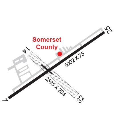
Airport Diagram might not be current. Facility Name: SOMERSET COUNTY City Name: SOMERSET County: SOMERSET State abbrev: PA State Name: PENNSYLVANIA Ownership: PUBLICLY OWNED Use: OPEN TO THE PUBLIC Owner's Name: BD OF CO COMMISSIONERS Address: SOMERSET COUNTY COURTHOUSE SOMERSET, PA 15501 Owner's Phone: 814-445-1400 Manager's Name: DAVID WRIGHT Address: 159 AIRPORT LANE FRIEDENS, PA 15541 Phone: 814-445-1599 FAA Region: EASTERN FAA Field Office: HAR
Runway Identifications Help
Runway Identification: 07/25 Length: 5002 ftWidth: 75 ftSurface: ASPHALT-GOOD CONDITIONEdge lights: Medium Intensity Treatment: NONE Runway: 07 Runway: 25 Mag heading: 66° Mag heading: 246° Rwy Slope: -1.47% Down Rwy Slope: 1.47% Up Approach: Approach: LOCALIZER Pattern: Left Traffic Pattern: Left Traffic Markings: NONPRECISION INSTRUMENT Markings: NONPRECISION INSTRUMENT Marking Condition: FAIR Marking Condition: FAIR Arresting Dev: Arresting Dev: Lat & Long: N4002.1 W07901.3 Lat. & Long.: N4002.6 W07900.5 Elev: 2275.0 ft. MSL Elev: 2201.6 ft. MSL TCH: 56 ft. AGL TCH: 29 ft. AGL Visual Glide Path: 3.00 degrees Visual Glide Path: 3.00 degrees Displaced Threshold: No Displaced Threshold: No Touchdown Zone: YES Touchdown Zone: YES Touchdown Elev.: 2275.0 feet Touchdown Elev.: 2240.3 feet Visual Glide Slope: 2-Light PAPI on LEFT side of Runway Visual Glide Slope: PULSATING/STEADY BURNING VASI ON LEFT SIDE OF RUNWAY RVR Equipment: RVR Equipment: RVV Equipment: NO RVV Equipment: NO Approach Lights: Approach Lights: REIL: YES REIL: YES Centerline Lights: NO Centerline Lights: NO Touchdown lights: NO Touchdown lights: NO Runway Category: Runway with a Non-precision Approach having visibility minimums greater than 3/4 mile Runway Category: Runway with a Non-precision Approach having visibility minimums greater than 3/4 mile Declared Distances: Declared Distances: Obstructions: Obstructions: POLE Marked: Marked: NOT Marked/Lighted Clearance slope: 34:1 Clearance slope: 19:1 Obstruction height: Obstruction height: 18 feet AGL Dist. from runway: Dist. from runway: 544 feet Centerline offset: Centerline offset: 180 feet left of centerline Comments: Comments:
Runway Identification: 14/32 Length: 2729 ftWidth: 150 ftSurface: GRASS-GOOD CONDITIONEdge lights: Treatment: NONE Runway: 14 Runway: 32 Mag heading: 141° Mag heading: 321° Rwy Slope: 1.01% Up Rwy Slope: -1.01% Down Approach: Approach: Pattern: Left Traffic Pattern: Left Traffic Markings: NONSTANDARD Markings: NONSTANDARD Marking Condition: GOOD; YELLOW CONES Marking Condition: GOOD; YELLOW CONES Arresting Dev: Arresting Dev: Lat & Long: N4002.4 W07901.2 Lat. & Long.: N4002.1 W07900.7 Elev: 2227.8 ft. MSL Elev: 2255.4 ft. MSL TCH: TCH: Visual Glide Path: Visual Glide Path: Displaced Threshold: 335 feet; 335 FT DTHR MKD WITH YELLOW CONES. Displaced Threshold: No Touchdown Zone: YES Touchdown Zone: YES Touchdown Elev.: 2255.4 feet Touchdown Elev.: 2255.4 feet Visual Glide Slope: Visual Glide Slope: RVR Equipment: RVR Equipment: RVV Equipment: NO RVV Equipment: NO Approach Lights: Approach Lights: REIL: NO REIL: NO Centerline Lights: NO Centerline Lights: NO Touchdown lights: NO Touchdown lights: NO Runway Category: Runway with a Visual Approach Runway Category: Runway with a Visual Approach Declared Distances: Declared Distances: Obstructions: ROAD; ROAD ANGLES ACRS RCL. Obstructions: TREES Marked: NOT Marked/Lighted Marked: NOT Marked/Lighted Clearance slope: 2:1; RWY 14 36 FT TREES 578 FT FM RWY 9 FT L. 25:1 BASED ON DTHR. Clearance slope: 15:1 Obstruction height: 16 feet AGL Obstruction height: 24 feet AGL Dist. from runway: 40 feet Dist. from runway: 352 feet Centerline offset: 124 left of centerline Centerline offset: 74 feet left of centerline Comments: Comments: