Current Weather/Notams (Metars, TAFs, Notams, NWS Forecast, PIREPS, and nearby weather)
Customs Information Send updates to Support@FltPlan.com
Customs Not Available
Database effective 05/16/2024
Airport Diagram might not be current.
|
| Facility Name: | CONCORD AIRPARK |
| City Name: | PAINESVILLE |
| County: | LAKE |
| State abbrev: | OH |
| State Name: | OHIO |
| | |
| Ownership: | PRIVATELY OWNED |
| Use: | OPEN TO THE PUBLIC |
| Owner's Name: | CONCORD AIRPARK, INC |
| Address: | 12361 CONCORD-HAMBDEN RD |
| | PAINESVILLE, OH 44077-9253 |
| Owner's Phone: | 440-352-3228; UNATNDD ARPT PHONE. |
| | |
| Manager's Name: | CONNIE LUHTA |
| Address: | 12253 CONCORD-HAMBDEN RD |
| | PAINESVILLE, OH 44077-9566 |
| Phone: | 440-227-1368; MGR RESNC. |
| | |
| FAA Region: | GREAT LAKES |
| FAA Field Office: | DET |
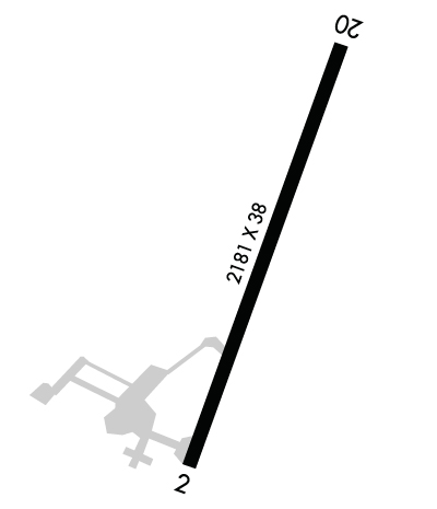
Runway Identifications
Runway Identification: 03/21Length: 2181 ft
Width: 38 ft
Surface: ASPHALT-FAIR CONDITION
Edge lights: Low IntensityTreatment: NONE
| | Runway: 03 | | Runway: 21 |
| Mag heading: | 29° | Mag heading: | 209° |
| Rwy Slope: | -1.22% Down | Rwy Slope: | 1.22% Up |
| Approach: | | Approach: | |
| Pattern: | Left Traffic | Pattern: | Left Traffic |
| Markings: | BASIC | Markings: | BASIC |
| Marking Condition: | POOR; FADED. | Marking Condition: | POOR; FADED. |
| Arresting Dev: | | Arresting Dev: | |
| Lat & Long: | N4139.9 W08111.9 | Lat. & Long.: | N4140.2 W08111.7 |
| Elev: | 994.1 ft. MSL | Elev: | 967.6 ft. MSL |
| TCH: | | TCH: | |
| Visual Glide Path: | | Visual Glide Path: | |
| Displaced Threshold: | No | Displaced Threshold: | No |
| Touchdown Zone: | YES | Touchdown Zone: | YES |
| Touchdown Elev.: | 998.6 feet | Touchdown Elev.: | 998.6 feet |
| Visual Glide Slope: | | Visual Glide Slope: | |
| RVR Equipment: | | RVR Equipment: | |
| RVV Equipment: | NO | RVV Equipment: | NO |
| Approach Lights: | | Approach Lights: | |
| REIL: | NO | REIL: | NO |
| Centerline Lights: | NO | Centerline Lights: | NO |
| Touchdown lights: | NO | Touchdown lights: | NO |
| Runway Category: | Runway with a Visual Approach | Runway Category: | Runway with a Visual Approach |
| Declared Distances: | | Declared Distances: | |
| Obstructions: | TREES | Obstructions: | TREES |
| Marked: | NOT Marked/Lighted | Marked: | NOT Marked/Lighted |
| Clearance slope: | 1:1 | Clearance slope: | 1:1 |
| Obstruction height: | 73 feet AGL | Obstruction height: | 75 feet AGL |
| Dist. from runway: | 258 feet | Dist. from runway: | 201 feet |
| Centerline offset: | 64 right of centerline | Centerline offset: | 121 feet right of centerline |
| Comments: | 40 FT TREES 50-199 FT DSTC 125 FT L & R. | Comments: | 20-50 FT TREES 0 FT DSTC. |

