Click here for more info on on SMS!

K2F7

COMMERCE MUNI
COMMERCE
TX
Time Zone: Central
Lat: N 3317.6
Long: W 09553.8
Elev: 516
Var: -04
Longest Runway: 3907
CTAF: 122.9

FBO & Flight Services info for K2F7

FBOs: Update your Fuel Prices

COMMERCE MUNIPh: 903-886-1101
-
Freq: 122.9
Service
Jet
100LL
SAF
MoGas
Fuel Avail: ~~Fuel is not available UFN 2/2023
Full        Last Update: 04/26/2024 00:15:41

Self        
 Address: 1119 ALAMO ST   COMMERCE, TX 75428
If you are an FBO, call 1-203-262-1700 to update your info or email: FltPlan.Advertising@garmin.com
Advertise your FBO on FltPlan.com

Runway & Approach Info for K2F7
Rwy
Length
Land Dist**
Approach*
  Rwy
Length
Land Dist**
Approach*
18
3907x60  3907'          
 
  
36
  3907x60  3907'          
 
 * only ILS, LOC, LDA, and SDF approaches to a specific runway are shown
** For any Declared Landing Distance Available, please see A/FD or Approach plates
Runway Weight Capability (lbs.) Help
Runway IDSingle WheelDouble WheelDouble Tandem WheelDual Double Wheel
18/3613,000N/AN/AN/A
These numbers are Advisory and are not limits.   The Airport Manager should have more accurate Weight Limits
Approach Charts
Approaches    
Current Weather/Notams
Customs Information Send updates to Support@FltPlan.com
Customs Not Available
Database effective 05/16/2024
Airport Diagram of K2F7
Airport Diagram might not be current.

Facility Name: COMMERCE MUNI
City Name: COMMERCE
County: HUNT
State abbrev: TX
State Name: TEXAS
   
Ownership: PUBLICLY OWNED
Use: OPEN TO THE PUBLIC
Owner's Name: CITY OF COMMERCE
Address: 1119 ALAMO
 COMMERCE, TX 75428
Owner's Phone: 903-886-1101
  
Manager's Name: JON HARPER; DIRECTOR OF COMMUNITY DEVELOPMENT.
Address: 1119 ALAMO
 COMMERCE, TX 75428
Phone: 903-886-1101
   
FAA Region: SOUTHWEST
FAA Field Office: TEX


Sunrise / Sunset times for COMMERCE MUNI

DateSunriseSunset
04/25/24 Thursday6:4120:02
04/26/24 Friday6:4020:03
04/27/24 Saturday6:3920:04
04/28/24 Sunday6:3820:05
04/29/24 Monday6:3720:05
04/30/24 Tuesday6:3620:06
05/01/24 Wednesday6:3520:07
05/02/24 Thursday6:3420:08
05/03/24 Friday6:3320:08
05/04/24 Saturday6:3220:09
05/05/24 Sunday6:3120:10
05/06/24 Monday6:3020:11
05/07/24 Tuesday6:2920:11
05/08/24 Wednesday6:2820:12

Airport Facilities

Airport Attendance ScheduleUNATTENDED; FOR ATTENDANT MON-FRI 0800-1700 CALL 903-886-1101; AFT HRS CALL 903-886-1139 (COMMERCE POLICE DEPT).
Airport Status OPERATIONAL (This Status can change at any time - please check NOTAMS)
Airport Lighting ScheduleMIRL RWY 18/36 PRESET TO LOW INTST; TO INCR INTST AND ACTVT - CTAF.
Airport Storage AvailableTie Downs
Extra Services AvailableNONE
Wind IndicatorYES - (lighted)
Control TowerNO
CTAF Frequency122.900
Unicom Frequency
Rotating Beacon ColorWG
Segmented CircleYES
Landing FeeNO

Airport Inspection Data

Airport InspectedSTATE - performed by PRIVATE CONTRACT PERSONNEL
Inspection Date09/15/2022

Airport Services

Type of Fuel AvailableGrade 100LL; -10SELF SERVE FUEL.
Airframe Repair ServiceMAJOR; 904-461-1374
Power Plant Repair ServiceMAJOR

Geographic Data

LatitudeN3317.6
LongitudeW09553.8 (ESTIMATED)
Arpt Elevation515ft (SURVEYED)
Magnetic Variation04E
3 miles Nof COMMERCE
Traffic Pattern Altitude
Sectional ChartDALLAS-FT WORTH

Aircraft Data

Operations (Reported)YearlyAvg. Daily
General Aviation Transient 400011
General Aviation Local 10003
Air Taxi 00
Commerical 00
Commuter 00
Military 00
Aircraft based on Field
General Aviation Singles 14
General Aviation Multi 2
Jet Aircraft 0
General Aviation Helicopters 0
Military Aircraft 0
Gliders 0
Ultralights 0

FAA Services

FSS on field NO
FSS tie-in FORT WORTH
FSS Phone 1-800-WX-BRIEF
Who issues Notams FTW
Notam D service at airport YES
ARTCC Name FORT WORTH

Federal Status

Airport Certification
Aircraft Rescue & Firefighting IndexNone
Airport of EntryNo
Custom Landing RightsNo
Joint Civil/MilitaryNo
Military Landing rightsYES

Federal Agreements

NATIONAL PLAN OF INTEGRATED AIRPORT SYSTEMS (NPIAS)
GRANT AGREEMENTS UNDER FAAP/ADAP/AIP
ASSURANCES PURSUANT TO TITLE VI, CIVIL RIGHTS ACT OF 1964

Remarks

FOR CD CTC FORT WORTH ARTCC AT 817-858-7584.
Airport Communications & Frequencies:
CTAF Frequency:
122.900
Remarks
  • APCH/DEP CTL SVC PRVDD BY FORT WORTH ARTCC (ZFW) ON FREQS 127.6/254.3 (DOBB CITY/B RCAG).
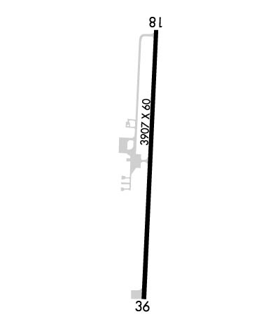
  • Runway Identifications
    Runway Identification: 18/36
    Length: 3907 ft
    Width: 60 ft
    Surface: ASPHALT-GOOD CONDITION
    Edge lights: Medium Intensity

    Treatment: NONE

     Runway: 18   Runway: 36
    Mag heading: 179°Mag heading: 359°
    Rwy Slope: -.24% DownRwy Slope: .24% Up
    Approach: Approach:
    Pattern: Left TrafficPattern: Left Traffic
    Markings: NONPRECISION INSTRUMENTMarkings: NONPRECISION INSTRUMENT
    Marking Condition: POOR; RWY MKGS FADED.Marking Condition: POOR; RWY MKGS FADED.
    Arresting Dev: Arresting Dev:
    Lat & Long: N3317.9  W09553.8Lat. & Long.: N3317.3  W09553.8
    Elev: 515.5 ft. MSLElev: 506.0 ft. MSL
    TCH: 40 ft. AGLTCH: 40 ft. AGL
    Visual Glide Path: 3.00 degreesVisual Glide Path: 3.00 degrees
    Displaced Threshold: NoDisplaced Threshold: No
    Touchdown Zone: YESTouchdown Zone: YES
    Touchdown Elev.: 515.5 feetTouchdown Elev.: 511.9 feet
    Visual Glide Slope: 2-Light PAPI on LEFT side of RunwayVisual Glide Slope: 2-Light PAPI on LEFT side of Runway
    RVR Equipment: RVR Equipment:
    RVV Equipment: NORVV Equipment: NO
    Approach Lights: Approach Lights:
    REIL: NOREIL: NO
    Centerline Lights: NOCenterline Lights: NO
    Touchdown lights: NOTouchdown lights: NO
    Runway Category: Runway with a Non-precision ApproachRunway Category: Runway with a Non-precision Approach
    Declared Distances: Declared Distances:
    Obstructions: TREESObstructions: TREE
    Marked: NOT Marked/LightedMarked: NOT Marked/Lighted
    Clearance slope: 15:1Clearance slope: 18:1
    Obstruction height: 36 feet AGLObstruction height: 26 feet AGL
    Dist. from runway: 745 feetDist. from runway: 680 feet
    Centerline offset: 250 right of centerlineCenterline offset: 250 feet left of centerline
    Comments: Comments: 8 FT TREE, 30 FT DSTC, 247 L.
    C:/P: