
| ||||||||||||||||||||||||||||||||||||||||||||
| ||||||||||||||||||||||||||||||||||||||||||||
| ||||||||||||||||||||||||||||||||||||||||||||
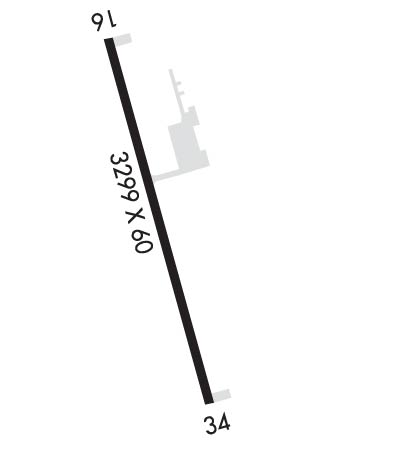
| Rwy | Rwy | |||||||
| 3299x60 | 3299' | 3299x60 | 3299' | |||||
| Runway ID | Single Wheel | Double Wheel | Double Tandem Wheel | Dual Double Wheel |
| 16/34 | 12,500 | N/A | N/A | N/A |
| These numbers are Advisory and are not limits. The Airport Manager should have more accurate Weight Limits | ||||
 Airport Diagram might not be current. | |
| Facility Name: | CAVALIER MUNI |
| City Name: | CAVALIER |
| County: | PEMBINA |
| State abbrev: | ND |
| State Name: | NORTH DAKOTA |
| Ownership: | PUBLICLY OWNED |
| Use: | OPEN TO THE PUBLIC |
| Owner's Name: | CAVALIER ARPT AUTHORITY |
| Address: | P O BOX 411 |
| CAVALIER, ND 58220 | |
| Owner's Phone: | (701) 520-8631 |
| Manager's Name: | HAROLD MCCONNELL |
| Address: | PO BOX 411 |
| CAVALIER, ND 58220 | |
| Phone: | 701-520-8631; ADDL ARPT CONTACT JEREMY SENG 701-520-5066. |
| FAA Region: | GREAT LAKES |
| FAA Field Office: | DMA |
| Date | Sunrise | Sunset |
|---|---|---|
| 04/19/24 Friday | 6:30 | 20:29 |
| 04/20/24 Saturday | 6:29 | 20:31 |
| 04/21/24 Sunday | 6:27 | 20:32 |
| 04/22/24 Monday | 6:25 | 20:34 |
| 04/23/24 Tuesday | 6:23 | 20:35 |
| 04/24/24 Wednesday | 6:21 | 20:37 |
| 04/25/24 Thursday | 6:19 | 20:38 |
| 04/26/24 Friday | 6:18 | 20:40 |
| 04/27/24 Saturday | 6:16 | 20:41 |
| 04/28/24 Sunday | 6:14 | 20:43 |
| 04/29/24 Monday | 6:12 | 20:44 |
| 04/30/24 Tuesday | 6:11 | 20:46 |
| 05/01/24 Wednesday | 6:09 | 20:47 |
| 05/02/24 Thursday | 6:07 | 20:48 |
| Airport Attendance Schedule | 7 Days A Week ON CALL |
| Airport Status | OPERATIONAL (This Status can change at any time - please check NOTAMS) |
| Airport Lighting Schedule | ACTVT REIL RWY 34; PAPI RWY 16 & 34; MIRL RWY 16/34 - CTAF. |
| Airport Storage Available | Tie Downs |
| Extra Services Available | Crop Dusting, Aircraft Sales |
| Wind Indicator | YES - (lighted) |
| Control Tower | NO |
| CTAF Frequency | 122.800 |
| Unicom Frequency | 122.800 |
| Rotating Beacon Color | WG |
| Segmented Circle | YES |
| Landing Fee | NO |
| Airport Inspected | STATE - performed by STATE AERONAUTICAL PERSONNEL |
| Inspection Date | 09/28/2022 |
| Type of Fuel Available | Grade 100LL, JET A (freeze point -40C); -10SELF SVC FUEL AVBL H24 VIA CREDIT CARD. |
| Airframe Repair Service | MAJOR; CALL 701-520-3055. |
| Power Plant Repair Service | MAJOR; CALL 701-520-3055. |
| Latitude | N4847.0 |
| Longitude | W09737.9 (ESTIMATED) |
| Arpt Elevation | 892ft (SURVEYED) |
| Magnetic Variation | 06E |
| 1 miles SW | of CAVALIER |
| Traffic Pattern Altitude | |
| Sectional Chart | TWIN CITIES |
| Operations (Reported) | Yearly | Avg. Daily |
|---|---|---|
| General Aviation Transient | 3000 | 8 |
| General Aviation Local | 3000 | 8 |
| Air Taxi | 200 | 1 |
| Commerical | 0 | 0 |
| Commuter | 0 | 0 |
| Military | 250 | 1 |
| Aircraft based on Field | |
|---|---|
| General Aviation Singles | 17 |
| General Aviation Multi | 1 |
| Jet Aircraft | 0 |
| General Aviation Helicopters | 0 |
| Military Aircraft | 0 |
| Gliders | 1 |
| Ultralights | 0 |
| FSS on field | NO |
| FSS tie-in | GRAND FORKS |
| FSS Phone | 1-800-WX-BRIEF |
| Who issues Notams | GFK |
| Notam D service at airport | YES |
| ARTCC Name | MINNEAPOLIS |
| Airport Certification | |
| Aircraft Rescue & Firefighting Index | None |
| Airport of Entry | No |
| Custom Landing Rights | No |
| Joint Civil/Military | No |
| Military Landing rights | No |
| NATIONAL PLAN OF INTEGRATED AIRPORT SYSTEMS (NPIAS) |
| GRANT AGREEMENTS UNDER FAAP/ADAP/AIP |
| ASSURANCES PURSUANT TO TITLE VI, CIVIL RIGHTS ACT OF 1964 |
| HELIPAD LOCATED SOUTH EDGE OF APRON. |
| CFM SNOW REMOVAL WITH AMGR AFT WINT STORM. |
| RY 34 +31' PLINE 1300' FM THLD ON CL; APCH RATIO 35:1. |
| RY 16 +45' MARKED PLINE 1920' FM THLD ON CL; APCH RATIO 38:1. |
| FOR CD CTC MINNEAPOLIS ARTCC AT 651-463-5588. |
Airport Communications & Frequencies:
| |||||||||
| Runway: 16 | Runway: 34 | ||
| Mag heading: | 160° | Mag heading: | 340° |
| Rwy Slope: | -.03% Down | Rwy Slope: | .03% Up |
| Approach: | Approach: | ||
| Pattern: | Left Traffic | Pattern: | Left Traffic |
| Markings: | NONPRECISION INSTRUMENT | Markings: | NONPRECISION INSTRUMENT |
| Marking Condition: | FAIR | Marking Condition: | FAIR |
| Arresting Dev: | Arresting Dev: | ||
| Lat & Long: | N4847.3 W09738.0 | Lat. & Long.: | N4846.8 W09737.8 |
| Elev: | 892.1 ft. MSL | Elev: | 891.1 ft. MSL |
| TCH: | 26 ft. AGL | TCH: | 36 ft. AGL |
| Visual Glide Path: | 3.00 degrees | Visual Glide Path: | 4.00 degrees |
| Displaced Threshold: | No | Displaced Threshold: | No |
| Touchdown Zone: | YES | Touchdown Zone: | YES |
| Touchdown Elev.: | 892.1 feet | Touchdown Elev.: | 892.1 feet |
| Visual Glide Slope: | 2-Light PAPI on LEFT side of Runway | Visual Glide Slope: | 2-Light PAPI on LEFT side of Runway; PAPI UNUSBL BYD 5 DEGS RIGHT OF CNTRLN. |
| RVR Equipment: | RVR Equipment: | ||
| RVV Equipment: | NO | RVV Equipment: | NO |
| Approach Lights: | Approach Lights: | ||
| REIL: | NO | REIL: | YES |
| Centerline Lights: | NO | Centerline Lights: | NO |
| Touchdown lights: | NO | Touchdown lights: | NO |
| Runway Category: | Runway with a Non-precision Approach | Runway Category: | Runway with a Non-precision Approach |
| Declared Distances: | Declared Distances: | ||
| Obstructions: | Obstructions: | BLDG | |
| Marked: | Marked: | NOT Marked/Lighted | |
| Clearance slope: | 20:1 | Clearance slope: | 20:1 |
| Obstruction height: | Obstruction height: | 72 feet AGL | |
| Dist. from runway: | Dist. from runway: | 1645 feet | |
| Centerline offset: | Centerline offset: | 455 feet right of centerline | |
| Comments: | Comments: |
