Click here for more info on on SMS!

K2B7

PITTSFIELD MUNI
PITTSFIELD
ME
Time Zone: Eastern
Lat: N 4446.1
Long: W 06922.5
Elev: 197
Var: +17
Longest Runway: 4003
CTAF: 122.8

FBO & Flight Services info for K2B7

FBOs: Update your Fuel Prices

CURTIS AIRPh: 207-487-5213 Fax: 207- 487-691 Freq: 122.8
Service
Jet
100LL
SAF
MoGas
Fuel Avail: JET A INCLUDES PRIST.
Full4.836.18    Last Update: 03/27/2024 09:13

Self        
 Address: 176 HARRISON ST,   PITTSFIELD, ME 04967
If you are an FBO, call 1-203-262-1700 to update your info or email: FltPlan.Advertising@garmin.com
Advertise your FBO on FltPlan.com

Runway & Approach Info for K2B7
Rwy
Length
Land Dist**
Approach*
  Rwy
Length
Land Dist**
Approach*
18
4003x100  4003'          
 
  
36
  4003x100  4003'          
 
 * only ILS, LOC, LDA, and SDF approaches to a specific runway are shown
** For any Declared Landing Distance Available, please see A/FD or Approach plates
Runway Weight Capability (lbs.) Help
Runway IDSingle WheelDouble WheelDouble Tandem WheelDual Double Wheel
18/3638,00049,000N/AN/A
These numbers are Advisory and are not limits.   The Airport Manager should have more accurate Weight Limits
Approach Charts
Approaches    
Current Weather/Notams
Customs Information Send updates to Support@FltPlan.com
Customs Not Available
Database effective 05/16/2024
Airport Diagram of K2B7
Airport Diagram might not be current.

Facility Name: PITTSFIELD MUNI
City Name: PITTSFIELD
County: SOMERSET
State abbrev: ME
State Name: MAINE
   
Ownership: PUBLICLY OWNED
Use: OPEN TO THE PUBLIC
Owner's Name: TOWN OF PITTSFIELD
Address: 112 SOMERSET AVE
 PITTSFIELD, ME 04967
Owner's Phone: 207-487-3136
  
Manager's Name: KATHRYN RUTH; TOWN MGR.
Address: 112 SOMERSET AVE
 PITTSFIELD, ME 04967
Phone: 207-487-3136
   
FAA Region: NEW ENGLAND
FAA Field Office: NONE


Sunrise / Sunset times for PITTSFIELD MUNI

DateSunriseSunset
04/22/24 Monday5:4019:32
04/23/24 Tuesday5:3919:34
04/24/24 Wednesday5:3719:35
04/25/24 Thursday5:3519:36
04/26/24 Friday5:3419:37
04/27/24 Saturday5:3219:39
04/28/24 Sunday5:3119:40
04/29/24 Monday5:2919:41
04/30/24 Tuesday5:2819:42
05/01/24 Wednesday5:2619:43
05/02/24 Thursday5:2519:45
05/03/24 Friday5:2319:46
05/04/24 Saturday5:2219:47
05/05/24 Sunday5:2119:48

Airport Facilities

Airport Attendance Schedule7 Days A Week 0700-1700
Airport Status OPERATIONAL (This Status can change at any time - please check NOTAMS)
Airport Lighting ScheduleACTVT REIL RWY 18 & 36; PAPI RWY 36; MIRL RWY 18/36 - CTAF.
Airport Storage AvailableTie Downs, Hanger
Extra Services AvailableCharter, Flight Instruction, Aircraft Rental, Aircraft Sales
Wind IndicatorYES - (lighted)
Control TowerNO
CTAF Frequency122.800
Unicom Frequency122.800
Rotating Beacon ColorWG
Segmented CircleYES
Landing FeeNO

Airport Inspection Data

Airport InspectedSTATE - performed by PRIVATE CONTRACT PERSONNEL
Inspection Date08/23/2023

Airport Services

Type of Fuel AvailableGrade 100LL, JET A-1 (icing inhibitor, freeze point -50C); -10100LL FUEL AFT HRS, CALL 207-232-2318.
Airframe Repair ServiceMAJOR
Power Plant Repair ServiceMAJOR

Geographic Data

LatitudeN4446.1
LongitudeW06922.5 (ESTIMATED)
Arpt Elevation197ft (SURVEYED)
Magnetic Variation17W
1 miles SEof PITTSFIELD
Traffic Pattern Altitude
Sectional ChartMONTREAL

Aircraft Data

Operations (Reported)YearlyAvg. Daily
General Aviation Transient 500014
General Aviation Local 800022
Air Taxi 1000
Commerical 00
Commuter 00
Military 30008
Aircraft based on Field
General Aviation Singles 28
General Aviation Multi 5
Jet Aircraft 0
General Aviation Helicopters 0
Military Aircraft 0
Gliders 0
Ultralights 0

FAA Services

FSS on field NO
FSS tie-in BANGOR
FSS Phone 1-800-WX-BRIEF
Who issues Notams BGR
Notam D service at airport YES
ARTCC Name BOSTON

Federal Status

Airport Certification
Aircraft Rescue & Firefighting IndexNone
Airport of EntryNo
Custom Landing RightsNo
Joint Civil/MilitaryNo
Military Landing rightsYES

Federal Agreements

NATIONAL PLAN OF INTEGRATED AIRPORT SYSTEMS (NPIAS)
GRANT AGREEMENTS UNDER FAAP/ADAP/AIP
ASSURANCES PURSUANT TO TITLE VI, CIVIL RIGHTS ACT OF 1964
AGREEMENT UNDER DLAND OR DCLA HAS EXPIRED.

Remarks

DEER AND TURKEYS INVOF ARPT.
FOR CD CTC BANGOR APCH AT 207-561-2500 EXT 1.
Airport Communications & Frequencies:
CTAF Frequency:
122.800
Unicom Frequency:
122.800
BANGOR Primary Approach Frequencies:  
118.925
239.3
BANGOR Primary Departure Frequencies:  
118.925
239.3
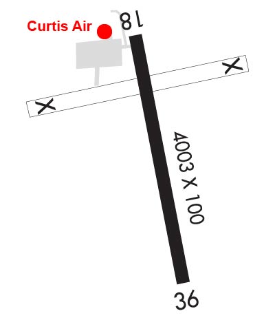
Runway Identifications
Runway Identification: 18/36
Length: 4003 ft
Width: 100 ft
Surface: ASPHALT-GOOD CONDITION
Edge lights: Medium Intensity

Treatment: NONE

 Runway: 18   Runway: 36
Mag heading: 184°Mag heading:
Rwy Slope: -.52% DownRwy Slope: .52% Up
Approach: Approach:
Pattern: Left TrafficPattern: Left Traffic
Markings: NONPRECISION INSTRUMENTMarkings: NONPRECISION INSTRUMENT
Marking Condition: POOR; NRS AND CNTRLN FADED OR MISG.Marking Condition: POOR; NRS AND CNTRLN FADED OR MISG.
Arresting Dev: Arresting Dev:
Lat & Long: N4446.4  W06922.6Lat. & Long.: N4445.8  W06922.4
Elev: 197.1 ft. MSLElev: 176.3 ft. MSL
TCH: TCH: 40 ft. AGL
Visual Glide Path: Visual Glide Path: 3.00 degrees
Displaced Threshold: NoDisplaced Threshold: No
Touchdown Zone: YESTouchdown Zone: YES
Touchdown Elev.: 197.1 feetTouchdown Elev.: 194.4 feet
Visual Glide Slope: Visual Glide Slope: 4-Light PAPI on LEFT side of Runway
RVR Equipment: RVR Equipment:
RVV Equipment: NORVV Equipment: NO
Approach Lights: Approach Lights:
REIL: YESREIL: YES
Centerline Lights: NOCenterline Lights: NO
Touchdown lights: NOTouchdown lights: NO
Runway Category: Runway with a Non-precision ApproachRunway Category: Runway with a Non-precision Approach
Declared Distances: Declared Distances:
Obstructions: POLEObstructions: BRUSH
Marked: NOT Marked/LightedMarked: NOT Marked/Lighted
Clearance slope: 16:1Clearance slope: 9:1
Obstruction height: 40 feet AGLObstruction height: 5 feet AGL
Dist. from runway: 842 feetDist. from runway: 249 feet
Centerline offset: 257 left of centerlineCenterline offset: 181 feet right of centerline
Comments: 6-10 FT BRUSH, 0-200 FT FM THR, 225-250 FT L OF CNTRLN.Comments: 20 FT TREES 0-50 FT FM THR, 210 FT L OF CNTRLN; 8 FT BRUSH 170-200 FT FM THR, 90 FT L OF CNTRLN.
C:5/P: