Approach Charts
| FltPlan does not have IFR approach charts available for K2A6. |
Current Weather/Notams (Metars, TAFs, Notams, NWS Forecast, PIREPS, and nearby weather)
Customs Information Send updates to Support@FltPlan.com
Customs Not Available
Database effective 05/16/2024
Airport Diagram might not be current.
|
| Facility Name: | HOLLY GROVE MUNI |
| City Name: | HOLLY GROVE |
| County: | MONROE |
| State abbrev: | AR |
| State Name: | ARKANSAS |
| | |
| Ownership: | PUBLICLY OWNED |
| Use: | OPEN TO THE PUBLIC |
| Owner's Name: | CITY OF HOLLY GROVE |
| Address: | P.O. BOX 430 |
| | HOLLY GROVE, AR 72069 |
| Owner's Phone: | 870-462-3422 |
| | |
| Manager's Name: | MIKE RICHARDSON |
| Address: | P.O. BOX 344 |
| | HOLLY GROVE, AR 72069 |
| Phone: | 870-462-3675 |
| | |
| FAA Region: | SOUTHWEST |
| FAA Field Office: | AOK |
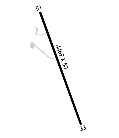
Runway Identifications
Runway Identification: 15/33Length: 4469 ft
Width: 50 ft
Surface: ASPHALT-FAIR CONDITION
Edge lights: Medium IntensityTreatment: NONE
| | Runway: 15 | | Runway: 33 |
| Mag heading: | N/A | Mag heading: | N/A |
| Rwy Slope: | .02% Up | Rwy Slope: | -.02% Down |
| Approach: | | Approach: | |
| Pattern: | Left Traffic | Pattern: | Left Traffic |
| Markings: | BASIC | Markings: | BASIC |
| Marking Condition: | GOOD | Marking Condition: | GOOD |
| Arresting Dev: | | Arresting Dev: | |
| Lat & Long: | N3435.3 W09110.2 | Lat. & Long.: | N3434.6 W09109.7 |
| Elev: | 175.0 ft. MSL | Elev: | 176.0 ft. MSL |
| TCH: | 10 ft. AGL | TCH: | 10 ft. AGL |
| Visual Glide Path: | 3.00 degrees | Visual Glide Path: | 3.00 degrees |
| Displaced Threshold: | No | Displaced Threshold: | No |
| Touchdown Zone: | NO | Touchdown Zone: | NO |
| Touchdown Elev.: | | Touchdown Elev.: | |
| Visual Glide Slope: | TRI-COLOR VASI ON LEFT SIDE OF RUNWAY; TRIL OTS INDEFLY | Visual Glide Slope: | TRI-COLOR VASI ON LEFT SIDE OF RUNWAY |
| RVR Equipment: | | RVR Equipment: | |
| RVV Equipment: | NO | RVV Equipment: | NO |
| Approach Lights: | | Approach Lights: | |
| REIL: | NO | REIL: | NO |
| Centerline Lights: | NO | Centerline Lights: | NO |
| Touchdown lights: | NO | Touchdown lights: | NO |
| Runway Category: | Runway with a Visual Approach | Runway Category: | Runway with a Visual Approach |
| Declared Distances: | | Declared Distances: | |
| Obstructions: | TREE | Obstructions: | FENCE |
| Marked: | NOT Marked/Lighted | Marked: | NOT Marked/Lighted |
| Clearance slope: | 22:1 | Clearance slope: | |
| Obstruction height: | 25 feet AGL | Obstruction height: | 10 feet AGL |
| Dist. from runway: | 750 feet | Dist. from runway: | 201 feet |
| Centerline offset: | 200 left of centerline | Centerline offset: | |
| Comments: | | Comments: | 10 FT FENCE 150 FT CROSSING RY EXTENDING INTO RPZ. |

