Click here for more info on on SMS!

K2A2

HOLLEY MOUNTAIN AIRPARK
CLINTON
AR
Time Zone: Central
Lat: N 3539.0
Long: W 09224.2
Elev: 1270
Var: -02
Longest Runway: 4795
CTAF: 122.7

FBO & Flight Services info for K2A2

FBOs: Update your Fuel Prices

AIRPORTPh: 501-745-8700
-
Freq: 122.7
Service
Jet
100LL
SAF
MoGas
Fuel Avail: NO FUEL AVAILABLE
Full        Last Update: 04/23/2024 05:40:08

Self        
If you are an FBO, call 1-203-262-1700 to update your info or email: FltPlan.Advertising@garmin.com
Advertise your FBO on FltPlan.com

Runway & Approach Info for K2A2
Rwy
Length
Land Dist**
Approach*
  Rwy
Length
Land Dist**
Approach*
05
4795x50  4397'          
 
  
23
  4795x50  4795'          
 
 * only ILS, LOC, LDA, and SDF approaches to a specific runway are shown
** For any Declared Landing Distance Available, please see A/FD or Approach plates
Runway Weight Capability (lbs.) Help
Runway IDSingle WheelDouble WheelDouble Tandem WheelDual Double Wheel
05/23N/AN/AN/AN/A
These numbers are Advisory and are not limits.   The Airport Manager should have more accurate Weight Limits
Approach Charts
Approaches    
Current Weather/Notams
Customs Information Send updates to Support@FltPlan.com
Customs Not Available
Database effective 05/16/2024
Airport Diagram of K2A2
Airport Diagram might not be current.

Facility Name: HOLLEY MOUNTAIN AIRPARK
City Name: CLINTON
County: VAN BUREN
State abbrev: AR
State Name: ARKANSAS
   
Ownership: PRIVATELY OWNED
Use: OPEN TO THE PUBLIC
Owner's Name: HOLLEY MOUNTAIN P.O.A.
Address: 302 NORTHRIDGE RD.
 CLINTON, AR 72031
Owner's Phone: (501) 253-4590
  
Manager's Name: MIKE FOOTE
Address: 302 NORTHRIDGE RD.
 CLINTON, AR 72031
Phone: 501-253-4590
   
FAA Region: SOUTHWEST
FAA Field Office: AOK


Sunrise / Sunset times for HOLLEY MOUNTAIN AIRPARK

DateSunriseSunset
04/22/24 Monday6:2719:49
04/23/24 Tuesday6:2619:50
04/24/24 Wednesday6:2519:51
04/25/24 Thursday6:2419:52
04/26/24 Friday6:2219:53
04/27/24 Saturday6:2119:54
04/28/24 Sunday6:2019:54
04/29/24 Monday6:1919:55
04/30/24 Tuesday6:1819:56
05/01/24 Wednesday6:1719:57
05/02/24 Thursday6:1619:58
05/03/24 Friday6:1519:59
05/04/24 Saturday6:1419:59
05/05/24 Sunday6:1320:00

Airport Facilities

Airport Attendance ScheduleUNATTENDED
Airport Status OPERATIONAL (This Status can change at any time - please check NOTAMS)
Airport Lighting ScheduleACTVT REIL RWYS 05 & 23; VASI RWY 05; MIRL RWY 05/23 - CTAF.
Airport Storage AvailableNONE
Extra Services AvailableNONE
Wind IndicatorYES - (lighted)
Control TowerNO
CTAF Frequency122.700
Unicom Frequency122.700
Rotating Beacon ColorWG
Segmented CircleNO
Landing Fee

Airport Inspection Data

Airport InspectedSTATE - performed by STATE AERONAUTICAL PERSONNEL
Inspection Date07/26/2023

Airport Services

Type of Fuel AvailableNone
Airframe Repair ServiceNone
Power Plant Repair ServiceNone

Geographic Data

LatitudeN3539.0
LongitudeW09224.2 (ESTIMATED)
Arpt Elevation1270ft (ESTIMATED)
Magnetic Variation02E
5 miles NEof CLINTON
Traffic Pattern Altitude
Sectional ChartMEMPHIS

Aircraft Data

Operations (Reported)YearlyAvg. Daily
General Aviation Transient 10003
General Aviation Local 20005
Air Taxi 00
Commerical 00
Commuter 00
Military 3001
Aircraft based on Field
General Aviation Singles 17
General Aviation Multi 2
Jet Aircraft 1
General Aviation Helicopters 0
Military Aircraft 0
Gliders 0
Ultralights 0

FAA Services

FSS on field NO
FSS tie-in JONESBORO
FSS Phone 1-800-WX-BRIEF
Who issues Notams JBR
Notam D service at airport YES
ARTCC Name MEMPHIS

Federal Status

Airport Certification
Aircraft Rescue & Firefighting IndexNone
Airport of EntryNo
Custom Landing RightsNo
Joint Civil/MilitaryNo
Military Landing rightsNo

Remarks

DEER ON & INVOF RY.
BEGINNING 10 FT BYD EAST END OF RWY 23 PAVEMENT, GND HAS APRX 10FT DROP OVER 40 FT LEN.
BEGINNING 50 FT BYD WEST END OF RWY 5 PAVEMENT, GND HAS APRX 25 FT DROP OVER 125 FT LEN.
RY 05/23 CLSD TO ACFT GROSS WT GREATER THAN 12,500 LBS.
FOR CD CTC MEMPHIS ARTCC AT 901-368-8453/8449.
WX INFO - CTAF (6 CLICKS).
Airport Communications & Frequencies:
CTAF Frequency:
122.700
Unicom Frequency:
122.700
Remarks
  • APCH/DEP SVC PRVDD BY MEMPHIS ARTCC ON FREQS 126.85/281.55 (HARRISON RCAG).
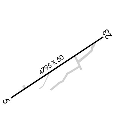
  • Runway Identifications
    Runway Identification: 05/23
    Length: 4795 ft
    Width: 50 ft
    Surface: ASPHALT-GOOD CONDITION
    Edge lights: Medium Intensity

    Treatment: NONE

     Runway: 05   Runway: 23
    Mag heading: 55°Mag heading: 235°
    Rwy Slope: .00%Rwy Slope: .00%
    Approach: Approach:
    Pattern: Left TrafficPattern: Right Traffic
    Markings: NONPRECISION INSTRUMENTMarkings: NONPRECISION INSTRUMENT
    Marking Condition: GOODMarking Condition: GOOD
    Arresting Dev: Arresting Dev:
    Lat & Long: N3538.8  W09224.6Lat. & Long.: N3539.3  W09223.8
    Elev: 1270.0 ft. MSLElev: 1270.0 ft. MSL
    TCH: 31 ft. AGLTCH: 47 ft. AGL
    Visual Glide Path: 3.50 degreesVisual Glide Path: 3.00 degrees
    Displaced Threshold: 398 feetDisplaced Threshold: No
    Touchdown Zone: YESTouchdown Zone: YES
    Touchdown Elev.: 1270.0 feetTouchdown Elev.: 1270.0 feet
    Visual Glide Slope: 2-Box VASI on LEFT side of Runway; VASI UNUSABLE BYD 2 DEGS LEFT & 7 DEGS RIGHT OF CENTERLINE.Visual Glide Slope: 2-Light PAPI on LEFT side of Runway
    RVR Equipment: RVR Equipment:
    RVV Equipment: NORVV Equipment: NO
    Approach Lights: Approach Lights:
    REIL: YESREIL: YES
    Centerline Lights: NOCenterline Lights: NO
    Touchdown lights: NOTouchdown lights: NO
    Runway Category: Runway with a Visual ApproachRunway Category: Runway with a Visual Approach
    Declared Distances: Declared Distances:
    Obstructions: TREESObstructions: TREES
    Marked: NOT Marked/LightedMarked: NOT Marked/Lighted
    Clearance slope: 6:1; APCH SLOPE 18:1 TO DTHR.Clearance slope: 32:1
    Obstruction height: 50 feet AGLObstruction height: 5 feet AGL
    Dist. from runway: 500 feetDist. from runway: 360 feet
    Centerline offset: 35 right of centerlineCenterline offset: 120 feet right of centerline
    Comments: Comments:
    C:/P: