Current Weather/Notams (Metars, TAFs, Notams, NWS Forecast, PIREPS, and nearby weather)
Customs Information Send updates to Support@FltPlan.com
Customs Not Available
Database effective 05/16/2024
Airport Diagram might not be current.
|
| Facility Name: | JAMESTOWN MUNI |
| City Name: | JAMESTOWN |
| County: | FENTRESS |
| State abbrev: | TN |
| State Name: | TENNESSEE |
| | |
| Ownership: | PUBLICLY OWNED |
| Use: | OPEN TO THE PUBLIC |
| Owner's Name: | CITY OF JAMESTOWN |
| Address: | CITY HALL PO BOX 670 |
| | JAMESTOWN, TN 38556 |
| Owner's Phone: | 931-879-8815 |
| | |
| Manager's Name: | RONNIE SEAGRAVES |
| Address: | 125 AIRPORT RD |
| | JAMESTOWN, TN 38556 |
| Phone: | 931-879-8948; AFT HR - 931-879-5685. |
| | |
| FAA Region: | SOUTHERN |
| FAA Field Office: | MEM |
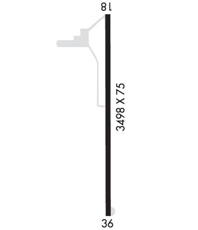
Runway Identifications
Runway Identification: 01/19Length: 3498 ft
Width: 75 ft
Surface: ASPHALT
Edge lights: Medium IntensityTreatment: NONE
| | Runway: 01 | | Runway: 19 |
| Mag heading: | 5° | Mag heading: | 185° |
| Rwy Slope: | .45% Up | Rwy Slope: | -.45% Down |
| Approach: | | Approach: | |
| Pattern: | Left Traffic | Pattern: | Left Traffic |
| Markings: | NONPRECISION INSTRUMENT | Markings: | NONPRECISION INSTRUMENT |
| Marking Condition: | FAIR | Marking Condition: | FAIR |
| Arresting Dev: | | Arresting Dev: | |
| Lat & Long: | N3620.7 W08456.8 | Lat. & Long.: | N3621.3 W08456.8 |
| Elev: | 1678.6 ft. MSL | Elev: | 1694.3 ft. MSL |
| TCH: | 30 ft. AGL | TCH: | 32 ft. AGL |
| Visual Glide Path: | 4.00 degrees | Visual Glide Path: | 4.00 degrees |
| Displaced Threshold: | No | Displaced Threshold: | No |
| Touchdown Zone: | YES | Touchdown Zone: | YES |
| Touchdown Elev.: | 1688.6 feet | Touchdown Elev.: | 1694.3 feet |
| Visual Glide Slope: | 4-Light PAPI on LEFT side of Runway | Visual Glide Slope: | 4-Light PAPI on LEFT side of Runway |
| RVR Equipment: | | RVR Equipment: | |
| RVV Equipment: | NO | RVV Equipment: | NO |
| Approach Lights: | | Approach Lights: | |
| REIL: | YES | REIL: | YES |
| Centerline Lights: | NO | Centerline Lights: | NO |
| Touchdown lights: | NO | Touchdown lights: | NO |
| Runway Category: | Runway with a Visual Approach | Runway Category: | Runway with a Visual Approach |
| Declared Distances: | | Declared Distances: | |
| Obstructions: | TREE | Obstructions: | TREE |
| Marked: | NOT Marked/Lighted | Marked: | NOT Marked/Lighted |
| Clearance slope: | 16:1 | Clearance slope: | 17:1 |
| Obstruction height: | 46 feet AGL | Obstruction height: | 90 feet AGL |
| Dist. from runway: | 941 feet | Dist. from runway: | 1803 feet |
| Centerline offset: | 2 left of centerline | Centerline offset: | 438 feet right of centerline |
| Comments: | | Comments: | |

