Approach Charts
| FltPlan does not have IFR approach charts available for K26A. |
Current Weather/Notams (Metars, TAFs, Notams, NWS Forecast, PIREPS, and nearby weather)
Customs Information Send updates to Support@FltPlan.com
Customs Not Available
Database effective 05/16/2024
Airport Diagram might not be current.
|
| Facility Name: | ASHLAND/LINEVILLE |
| City Name: | ASHLAND/LINEVILLE |
| County: | CLAY |
| State abbrev: | AL |
| State Name: | ALABAMA |
| | |
| Ownership: | PUBLICLY OWNED |
| Use: | OPEN TO THE PUBLIC |
| Owner's Name: | CLAY COUNTY COMMISSION |
| Address: | P. O. BOX 187 |
| | ASHLAND, AL 36251 |
| Owner's Phone: | (256) 354-7888 |
| | |
| Manager's Name: | MARK BRERETON |
| Address: | 375 AIRPORT ROAD |
| | ASHLAND, AL 36251 |
| Phone: | 706-506-8638 |
| | |
| FAA Region: | SOUTHERN |
| FAA Field Office: | JAN |
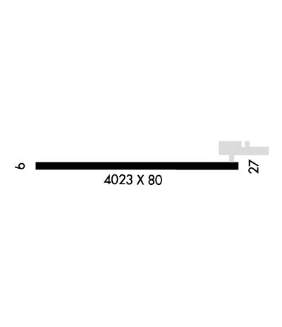
Runway Identifications
Runway Identification: 09/27Length: 4023 ft
Width: 80 ft
Surface: ASPHALT-GOOD CONDITION
Edge lights: Medium IntensityTreatment: NONE
| | Runway: 09 | | Runway: 27 |
| Mag heading: | N/A | Mag heading: | N/A |
| Rwy Slope: | -.21% Down | Rwy Slope: | .21% Up |
| Approach: | | Approach: | |
| Pattern: | Left Traffic | Pattern: | Left Traffic |
| Markings: | NONPRECISION INSTRUMENT | Markings: | NONPRECISION INSTRUMENT |
| Marking Condition: | GOOD | Marking Condition: | GOOD |
| Arresting Dev: | | Arresting Dev: | |
| Lat & Long: | N3317.1 W08548.9 | Lat. & Long.: | N3317.1 W08548.1 |
| Elev: | 1065.9 ft. MSL | Elev: | 1057.3 ft. MSL |
| TCH: | | TCH: | |
| Visual Glide Path: | | Visual Glide Path: | |
| Displaced Threshold: | 200 feet | Displaced Threshold: | No |
| Touchdown Zone: | NO | Touchdown Zone: | NO |
| Touchdown Elev.: | | Touchdown Elev.: | |
| Visual Glide Slope: | | Visual Glide Slope: | |
| RVR Equipment: | | RVR Equipment: | |
| RVV Equipment: | NO | RVV Equipment: | NO |
| Approach Lights: | | Approach Lights: | |
| REIL: | YES | REIL: | YES |
| Centerline Lights: | NO | Centerline Lights: | NO |
| Touchdown lights: | NO | Touchdown lights: | NO |
| Runway Category: | Runway with a Visual Approach | Runway Category: | Runway with a Visual Approach |
| Declared Distances: | TORA:4023' TODA:4023' | Declared Distances: | TORA:3823' TODA:4023' |
| Obstructions: | POLE | Obstructions: | TREE |
| Marked: | NOT Marked/Lighted | Marked: | NOT Marked/Lighted |
| Clearance slope: | 17:1; APCH RATIO 26:1 TO DSPLCD THR. | Clearance slope: | 25:1 |
| Obstruction height: | 44 feet AGL | Obstruction height: | 66 feet AGL |
| Dist. from runway: | 980 feet | Dist. from runway: | 1858 feet |
| Centerline offset: | 217 left of centerline | Centerline offset: | 39 feet left of centerline |
| Comments: | | Comments: | |

