Click here for more info on on SMS!

K25D

FOREST LAKE
FOREST LAKE
MN
Time Zone: Central
Lat: N 4514.8
Long: W 09259.6
Elev: 930
Var: -03
Longest Runway: 2700T
CTAF: 122.7

FBO & Flight Services info for K25D

FBOs: Update your Fuel Prices

AIRPORTPh: 651-464-3550
-
Freq: 122.7
Service
Jet
100LL
SAF
MoGas
Fuel Avail: ~~100LL AVAILABLE 24 HRS SELF SERVICE WITH CREDIT CARD
Full        Last Update: 04/19/2024 00:01:47

Self        
If you are an FBO, call 1-203-262-1700 to update your info or email: FltPlan.Advertising@garmin.com
Advertise your FBO on FltPlan.com

Runway & Approach Info for K25D
Rwy
Length
Land Dist**
Approach*
  Rwy
Length
Land Dist**
Approach*
13
2700x75  2700'          
 
  
31
  2700x75  2700'          
 
 * only ILS, LOC, LDA, and SDF approaches to a specific runway are shown
** For any Declared Landing Distance Available, please see A/FD or Approach plates
Runway Weight Capability (lbs.) Help
Runway IDSingle WheelDouble WheelDouble Tandem WheelDual Double Wheel
13/31N/AN/AN/AN/A
These numbers are Advisory and are not limits.   The Airport Manager should have more accurate Weight Limits
Approach Charts
FltPlan does not have IFR approach charts available for K25D.
Current Weather/Notams
Customs Information Send updates to Support@FltPlan.com
Customs Not Available
Database effective 04/18/2024
Airport Diagram of K25D
Airport Diagram might not be current.

Facility Name: FOREST LAKE
City Name: FOREST LAKE
County: WASHINGTON
State abbrev: MN
State Name: MINNESOTA
   
Ownership: PUBLICLY OWNED
Use: OPEN TO THE PUBLIC
Owner's Name: CITY OF FOREST LAKE
Address: 1408 LAKE STREET SOUTH
 FOREST LAKE, MN 55025
Owner's Phone: 651-464-3550
  
Manager's Name: PATRICK CASEY
Address: 1408 LAKE STREET SOUTH; EMAIL ADDRESS: DAN.UNDEM@CI.FOREST-LAKE.MN.US (ALL LOWER CASE).
 FOREST LAKE, MN 55025
Phone: 651-209-9750
   
FAA Region: GREAT LAKES
FAA Field Office: DMA


Sunrise / Sunset times for FOREST LAKE

DateSunriseSunset
04/18/24 Thursday6:2020:03
04/19/24 Friday6:1920:04
04/20/24 Saturday6:1720:05
04/21/24 Sunday6:1520:07
04/22/24 Monday6:1420:08
04/23/24 Tuesday6:1220:09
04/24/24 Wednesday6:1020:10
04/25/24 Thursday6:0920:12
04/26/24 Friday6:0720:13
04/27/24 Saturday6:0620:14
04/28/24 Sunday6:0420:15
04/29/24 Monday6:0320:17
04/30/24 Tuesday6:0120:18
05/01/24 Wednesday6:0020:19

Airport Facilities

Airport Attendance ScheduleUNATTENDED
Airport Status OPERATIONAL (This Status can change at any time - please check NOTAMS)
Airport Lighting ScheduleMIRL RY 13/31 PRESET TO LOW SS-SR; TO INCR INTST & ACTVT PAPI & REIL RY 13 & 31 - CTAF.
Airport Storage AvailableTie Downs
Extra Services AvailableAircraft Sales
Wind IndicatorYES - (unlit)
Control TowerNO
CTAF Frequency122.700
Unicom Frequency122.700
Rotating Beacon ColorWG
Segmented CircleNO
Landing FeeNO

Airport Inspection Data

Airport InspectedSTATE - performed by STATE AERONAUTICAL PERSONNEL
Inspection Date09/14/2023

Airport Services

Type of Fuel AvailableGrade 100LL; -10FUEL AVBL 24 HRS SELF SERVICE WITH CREDIT CARD.
Airframe Repair ServiceNONE
Power Plant Repair ServiceNONE

Geographic Data

LatitudeN4514.8
LongitudeW09259.6 (ESTIMATED)
Arpt Elevation929ft (SURVEYED)
Magnetic Variation03E
2 miles SWof FOREST LAKE
Traffic Pattern Altitude
Sectional ChartGREEN BAY

Aircraft Data

Operations (Reported)YearlyAvg. Daily
General Aviation Transient 15004
General Aviation Local 650018
Air Taxi 00
Commerical 00
Commuter 00
Military 00
Aircraft based on Field
General Aviation Singles 32
General Aviation Multi 0
Jet Aircraft 0
General Aviation Helicopters 1
Military Aircraft 0
Gliders 0
Ultralights 0

FAA Services

FSS on field NO
FSS tie-in PRINCETON
FSS Phone 1-800-WX-BRIEF
Who issues Notams PNM
Notam D service at airport YES
ARTCC Name MINNEAPOLIS

Federal Status

Airport Certification
Aircraft Rescue & Firefighting IndexNone
Airport of EntryNo
Custom Landing RightsNo
Joint Civil/MilitaryNo
Military Landing rightsNo

Remarks

CALM WIND RY 13.
FOR CD CTC MINNEAPOLIS APCH AT 612-726-9086.
RWY 13/3 1 STEEP DROP IN TERRAIN ALONG NORTHEAST SIDE OF RY.
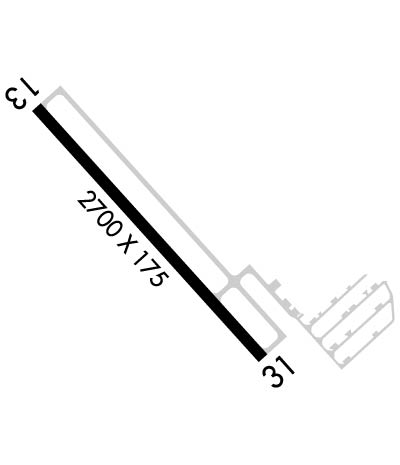
Runway Identifications
Runway Identification: 13/31
Length: 2700 ft
Width: 75 ft
Surface: ASPHALT-GOOD CONDITION
Edge lights: Medium Intensity

Treatment: NONE

 Runway: 13   Runway: 31
Mag heading: N/AMag heading: N/A
Rwy Slope: .16% UpRwy Slope: -.16% Down
Approach: Approach:
Pattern: Left TrafficPattern: Left Traffic
Markings: NONPRECISION INSTRUMENTMarkings: NONPRECISION INSTRUMENT
Marking Condition: FAIRMarking Condition: FAIR
Arresting Dev: Arresting Dev:
Lat & Long: N4515.0  W09259.8Lat. & Long.: N4514.7  W09259.4
Elev: 925.2 ft. MSLElev: 929.5 ft. MSL
TCH: 29 ft. AGLTCH: 31 ft. AGL
Visual Glide Path: 3.50 degreesVisual Glide Path: 3.50 degrees
Displaced Threshold: NoDisplaced Threshold: No
Touchdown Zone: YESTouchdown Zone: YES
Touchdown Elev.: 929.5 feetTouchdown Elev.: 929.5 feet
Visual Glide Slope: 4-Light PAPI on LEFT side of RunwayVisual Glide Slope: 4-Light PAPI on LEFT side of Runway
RVR Equipment: RVR Equipment:
RVV Equipment: NORVV Equipment: NO
Approach Lights: Approach Lights:
REIL: YESREIL: YES
Centerline Lights: NOCenterline Lights: NO
Touchdown lights: NOTouchdown lights: NO
Runway Category: Runway with a Visual ApproachRunway Category: Runway with a Visual Approach
Declared Distances: Declared Distances:
Comments: Comments: RWY 31 HAS 5 FT BRUSH 105 FT FROM THE RWY END AND 84 FT L.
C:/P: