Current Weather/Notams (Metars, TAFs, Notams, NWS Forecast, PIREPS, and nearby weather)
Customs Information Send updates to Support@FltPlan.com
Customs Not Available
Database effective 04/18/2024
Airport Diagram might not be current.
|
| Facility Name: | SUWANNEE COUNTY |
| City Name: | LIVE OAK |
| County: | SUWANNEE |
| State abbrev: | FL |
| State Name: | FLORIDA |
| | |
| Ownership: | PUBLICLY OWNED |
| Use: | OPEN TO THE PUBLIC |
| Owner's Name: | SUWANNEE COUNTY |
| Address: | 13150 80TH TERRACE |
| | LIVE OAK, FL 32064 |
| Owner's Phone: | 386-364-3400 |
| | |
| Manager's Name: | GREG SCOTT |
| Address: | 1201 SILAS DRIVE |
| | LIVE OAK, FL 32064 |
| Phone: | (386) 362-3004 |
| | |
| FAA Region: | SOUTHERN |
| FAA Field Office: | ORL |
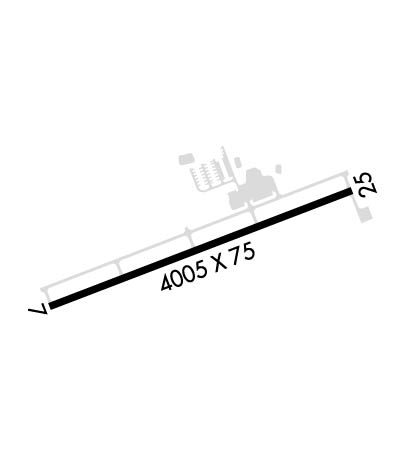
Runway Identifications
Runway Identification: 07/25Length: 4005 ft
Width: 75 ft
Surface: ASPHALT-FAIR CONDITION
Edge lights: Medium IntensityTreatment: NONE
Weight: PCN 30 /F/A/W/T
| | Runway: 07 | | Runway: 25 |
| Mag heading: | 74° | Mag heading: | 254° |
| Rwy Slope: | .05% Up | Rwy Slope: | -.05% Down |
| Approach: | | Approach: | |
| Pattern: | Left Traffic | Pattern: | Right Traffic |
| Markings: | NONPRECISION INSTRUMENT | Markings: | NONPRECISION INSTRUMENT |
| Marking Condition: | FAIR | Marking Condition: | FAIR |
| Arresting Dev: | | Arresting Dev: | |
| Lat & Long: | N3017.9 W08301.8 | Lat. & Long.: | N3018.1 W08301.1 |
| Elev: | 101.2 ft. MSL | Elev: | 103.3 ft. MSL |
| TCH: | 44 ft. AGL | TCH: | 51 ft. AGL |
| Visual Glide Path: | 3.00 degrees | Visual Glide Path: | 3.00 degrees |
| Displaced Threshold: | No | Displaced Threshold: | No |
| Touchdown Zone: | YES | Touchdown Zone: | YES |
| Touchdown Elev.: | 101.7 feet | Touchdown Elev.: | 103.3 feet |
| Visual Glide Slope: | 2-Light PAPI on LEFT side of Runway | Visual Glide Slope: | 2-Light PAPI on LEFT side of Runway |
| RVR Equipment: | | RVR Equipment: | |
| RVV Equipment: | NO | RVV Equipment: | NO |
| Approach Lights: | | Approach Lights: | |
| REIL: | YES | REIL: | YES |
| Centerline Lights: | NO | Centerline Lights: | NO |
| Touchdown lights: | NO | Touchdown lights: | NO |
| Runway Category: | Runway with a Non-precision Approach having visibility minimums greater than 3/4 mile | Runway Category: | Runway with a Non-precision Approach having visibility minimums greater than 3/4 mile |
| Declared Distances: | | Declared Distances: | |
| Obstructions: | TREES | Obstructions: | TREES |
| Marked: | NOT Marked/Lighted | Marked: | NOT Marked/Lighted |
| Clearance slope: | 23:1; APCH SLOPE 21:1 DUE TO 63 FT TREES 1515 FM RWY END 30 FT L. | Clearance slope: | 34:1; APCH SLOPE 30:1 DUE TO 46 FT TREES 1580 FT FM RWY END L & R. |
| Obstruction height: | 66 feet AGL | Obstruction height: | 47 feet AGL |
| Dist. from runway: | 1735 feet | Dist. from runway: | 1800 feet |
| Centerline offset: | 140 left of centerline | Centerline offset: | 260 feet left of centerline |
| Comments: | | Comments: | |

