Click here for more info on on SMS!

K24F

CYPRESS RIVER
JEFFERSON
TX
Time Zone: Central
Lat: N 3244.7
Long: W 09418.3
Elev: 221
Var: -05
Longest Runway: 3200
CTAF: 122.9

FBO & Flight Services info for K24F

FBOs: Update your Fuel Prices

AIRPORTPh: 903-665-3261
-
Freq: 122.9
Service
Jet
100LL
SAF
MoGas
Fuel Avail: NO FUEL AVAILABLE
Full        Last Update: 04/20/2024 05:45:17

Self        
If you are an FBO, call 1-203-262-1700 to update your info or email: FltPlan.Advertising@garmin.com
Advertise your FBO on FltPlan.com

Runway & Approach Info for K24F
Rwy
Length
Land Dist**
Approach*
  Rwy
Length
Land Dist**
Approach*
05
3200x60  3200'          
 
  
23
  3200x60  3200'          
 
 * only ILS, LOC, LDA, and SDF approaches to a specific runway are shown
** For any Declared Landing Distance Available, please see A/FD or Approach plates
Runway Weight Capability (lbs.) Help
Runway IDSingle WheelDouble WheelDouble Tandem WheelDual Double Wheel
05/2312,500N/AN/AN/A
These numbers are Advisory and are not limits.   The Airport Manager should have more accurate Weight Limits
Approach Charts
FltPlan does not have IFR approach charts available for K24F.
Current Weather/Notams
Customs Information Send updates to Support@FltPlan.com
Customs Not Available
Database effective 04/18/2024
Airport Diagram of K24F
Airport Diagram might not be current.

Facility Name: CYPRESS RIVER
City Name: JEFFERSON
County: MARION
State abbrev: TX
State Name: TEXAS
   
Ownership: PUBLICLY OWNED
Use: OPEN TO THE PUBLIC
Owner's Name: MARION COUNTY
Address: 119 W. LAFAYETTE ST, ROOM 206
 JEFFERSON, TX 75657
Owner's Phone: 903-665-3261; ALSO 906-665-8336 SANDRA WRIGHT ADMIN ASST TO CO JUDGE & CO COMM.
  
Manager's Name: TED MCKINNON
Address: 119 W. LAFAYETTE ST, ROOM 206
 JEFFERSON, TX 75657
Phone: 903-240-7707
   
FAA Region: SOUTHWEST
FAA Field Office: TEX


Sunrise / Sunset times for CYPRESS RIVER

DateSunriseSunset
04/19/24 Friday6:4219:51
04/20/24 Saturday6:4119:52
04/21/24 Sunday6:4019:52
04/22/24 Monday6:3919:53
04/23/24 Tuesday6:3819:54
04/24/24 Wednesday6:3619:54
04/25/24 Thursday6:3519:55
04/26/24 Friday6:3419:56
04/27/24 Saturday6:3319:57
04/28/24 Sunday6:3219:57
04/29/24 Monday6:3119:58
04/30/24 Tuesday6:3019:59
05/01/24 Wednesday6:2920:00
05/02/24 Thursday6:2820:00

Airport Facilities

Airport Attendance Schedule7 Days A Week IREG
Airport Status OPERATIONAL (This Status can change at any time - please check NOTAMS)
Airport Lighting ScheduleSS-SR
Airport Storage AvailableTie Downs, Hanger
Extra Services AvailableNONE
Wind IndicatorYES - (lighted)
Control TowerNO
CTAF Frequency122.900
Unicom Frequency
Rotating Beacon ColorWG
Segmented CircleNO
Landing FeeNO

Airport Inspection Data

Airport InspectedCONTRACTOR - performed by PRIVATE CONTRACT PERSONNEL
Inspection Date10/05/2022

Airport Services

Type of Fuel AvailableGrade 100LL; -1024 HR SELF SERV.
Airframe Repair ServiceNONE
Power Plant Repair ServiceNONE

Geographic Data

LatitudeN3244.7
LongitudeW09418.3 (ESTIMATED)
Arpt Elevation221ft (SURVEYED)
Magnetic Variation05E
3 miles Eof JEFFERSON
Traffic Pattern Altitude
Sectional ChartMEMPHIS

Aircraft Data

Operations (Reported)YearlyAvg. Daily
General Aviation Transient 8002
General Aviation Local 24007
Air Taxi 00
Commerical 00
Commuter 00
Military 00
Aircraft based on Field
General Aviation Singles 7
General Aviation Multi 1
Jet Aircraft 0
General Aviation Helicopters 0
Military Aircraft 0
Gliders 0
Ultralights 0

FAA Services

FSS on field NO
FSS tie-in FORT WORTH
FSS Phone 1-800-WX-BRIEF
Who issues Notams FTW
Notam D service at airport YES
ARTCC Name FORT WORTH

Federal Status

Airport Certification
Aircraft Rescue & Firefighting IndexNone
Airport of EntryNo
Custom Landing RightsNo
Joint Civil/MilitaryNo
Military Landing rightsNo

Federal Agreements

ASSURANCES PURSUANT TO TITLE VI, CIVIL RIGHTS ACT OF 1964
GRANT AGREEMENT HAS EXPIRED; HOWEVER, AGREEMENT REMAINS IN EFFECT FOR THIS FACILITY AS LONG AS IT IS PUBLIC USE.

Remarks

DEER ON & INVOF ARPT.
FOR CD CTC FORT WORTH ARTCC AT 817-858-7584.
TO ARRANGE COURTESY CAR CALL 903-240-7707 MON-FRI 0800-1700.
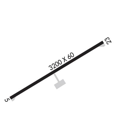
Runway Identifications
Runway Identification: 05/23
Length: 3200 ft
Width: 60 ft
Surface: ASPHALT-GOOD CONDITION
Edge lights: Low Intensity

Treatment: NONE

 Runway: 05   Runway: 23
Mag heading: 54°Mag heading: 234°
Rwy Slope: .01% UpRwy Slope: -.01% Down
Approach: Approach:
Pattern: Left TrafficPattern: Left Traffic
Markings: BASICMarkings: BASIC
Marking Condition: GOODMarking Condition: GOOD
Arresting Dev: Arresting Dev:
Lat & Long: N3244.5  W09418.5Lat. & Long.: N3244.8  W09418.0
Elev: 216.1 ft. MSLElev: 216.4 ft. MSL
TCH: 45 ft. AGLTCH: 45 ft. AGL
Visual Glide Path: 3.50 degreesVisual Glide Path: 3.50 degrees
Displaced Threshold: NoDisplaced Threshold: No
Touchdown Zone: YESTouchdown Zone: YES
Touchdown Elev.: 221.2 feetTouchdown Elev.: 221.2 feet
Visual Glide Slope: 2-Light PAPI on LEFT side of Runway; UNUSBL BYD 9 DEG LEFT OF RCL.Visual Glide Slope: 2-Light PAPI on LEFT side of Runway; UNUSBL BYD 7 DEG LEFT OF RCL.
RVR Equipment: RVR Equipment:
RVV Equipment: NORVV Equipment: NO
Approach Lights: Approach Lights:
REIL: NOREIL: NO
Centerline Lights: NOCenterline Lights: NO
Touchdown lights: NOTouchdown lights: NO
Runway Category: Runway with a Visual ApproachRunway Category: Runway with a Visual Approach
Declared Distances: Declared Distances:
Obstructions: TREESObstructions: TREES
Marked: NOT Marked/LightedMarked: NOT Marked/Lighted
Clearance slope: 18:1Clearance slope: 22:1
Obstruction height: 120 feet AGLObstruction height: 93 feet AGL
Dist. from runway: 2400 feetDist. from runway: 2275 feet
Centerline offset: Centerline offset:
Comments: Comments:
C:/P: