Approach Charts
| FltPlan does not have IFR approach charts available for K22I. |
Current Weather/Notams (Metars, TAFs, Notams, NWS Forecast, PIREPS, and nearby weather)
Customs Information Send updates to Support@FltPlan.com
Customs Not Available
Database effective 05/16/2024
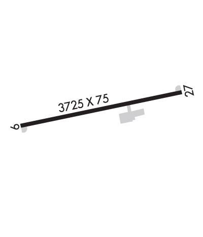
Airport Diagram might not be current.
|
| Facility Name: | VINTON COUNTY |
| City Name: | MC ARTHUR |
| County: | VINTON |
| State abbrev: | OH |
| State Name: | OHIO |
| | |
| Ownership: | PUBLICLY OWNED |
| Use: | OPEN TO THE PUBLIC |
| Owner's Name: | VINTON COUNTY |
| Address: | 100 E MAIN ST |
| | MC ARTHUR, OH 45651-1267 |
| Owner's Phone: | 740-357-0268 |
| | |
| Manager's Name: | NICK RUPERT |
| Address: | 66285 AIRPORT RD |
| | NEW PLYMOUTH, OH 45654-8927 |
| Phone: | 740-357-0268 |
| | |
| FAA Region: | GREAT LAKES |
| FAA Field Office: | DET |
Runway Identifications
Runway Identification: 09/27Length: 3725 ft
Width: 75 ft
Surface: ASPHALT-POOR CONDITION
Edge lights: Medium IntensityTreatment: NONE
| | Runway: 09 | | Runway: 27 |
| Mag heading: | N/A | Mag heading: | N/A |
| Rwy Slope: | .05% Up | Rwy Slope: | -.05% Down |
| Approach: | | Approach: | |
| Pattern: | Left Traffic | Pattern: | Left Traffic |
| Markings: | NONSTANDARD | Markings: | NONSTANDARD |
| Marking Condition: | POOR; FADED. | Marking Condition: | POOR; FADED. |
| Arresting Dev: | | Arresting Dev: | |
| Lat & Long: | N3919.6 W08226.9 | Lat. & Long.: | N3919.7 W08226.1 |
| Elev: | 956.0 ft. MSL | Elev: | 958.0 ft. MSL |
| TCH: | | TCH: | |
| Visual Glide Path: | | Visual Glide Path: | 4.00 degrees |
| Displaced Threshold: | No | Displaced Threshold: | No |
| Touchdown Zone: | NO | Touchdown Zone: | NO |
| Touchdown Elev.: | | Touchdown Elev.: | |
| Visual Glide Slope: | | Visual Glide Slope: | 2-Light PAPI on LEFT side of Runway |
| RVR Equipment: | | RVR Equipment: | |
| RVV Equipment: | NO | RVV Equipment: | NO |
| Approach Lights: | | Approach Lights: | |
| REIL: | NO | REIL: | NO |
| Centerline Lights: | NO | Centerline Lights: | NO |
| Touchdown lights: | NO | Touchdown lights: | NO |
| Runway Category: | Runway with a Visual Approach | Runway Category: | Runway with a Visual Approach |
| Declared Distances: | | Declared Distances: | |
| Obstructions: | TREES | Obstructions: | BRUSH |
| Marked: | NOT Marked/Lighted | Marked: | NOT Marked/Lighted |
| Clearance slope: | 4:1 | Clearance slope: | 5:1 |
| Obstruction height: | 53 feet AGL | Obstruction height: | 10 feet AGL |
| Dist. from runway: | 460 feet | Dist. from runway: | 256 feet |
| Centerline offset: | 110 right of centerline | Centerline offset: | 82 feet right of centerline |
| Comments: | | Comments: | |

