Click here for more info on on SMS!

K1X1

HIGGINS-LIPSCOMB COUNTY
HIGGINS
TX
Time Zone: Central
Lat: N 3606.4
Long: W 10001.5
Elev: 2566
Var: -08
Longest Runway: 3969
CTAF: 122.9

FBO & Flight Services info for K1X1

FBOs: Update your Fuel Prices

LISCOMB CO ARPTPh: 806-852-4231
-
Freq: 122.9
Service
Jet
100LL
SAF
MoGas
Fuel Avail: NO FUEL AVAILABLE
Full        Last Update: 04/19/2024 00:01:45

Self        
If you are an FBO, call 1-203-262-1700 to update your info or email: FltPlan.Advertising@garmin.com
Advertise your FBO on FltPlan.com

Runway & Approach Info for K1X1
Rwy
Length
Land Dist**
Approach*
  Rwy
Length
Land Dist**
Approach*
18
3969x60  3773'          
 
  
36
  3969x60  3969'          
 
 * only ILS, LOC, LDA, and SDF approaches to a specific runway are shown
** For any Declared Landing Distance Available, please see A/FD or Approach plates
Runway Weight Capability (lbs.) Help
Runway IDSingle WheelDouble WheelDouble Tandem WheelDual Double Wheel
18/3612,500N/AN/AN/A
These numbers are Advisory and are not limits.   The Airport Manager should have more accurate Weight Limits
Approach Charts
Approaches    
Current Weather/Notams
Customs Information Send updates to Support@FltPlan.com
Customs Not Available
Database effective 04/18/2024
Airport Diagram of K1X1
Airport Diagram might not be current.

Facility Name: HIGGINS/LIPSCOMB COUNTY
City Name: HIGGINS
County: LIPSCOMB
State abbrev: TX
State Name: TEXAS
   
Ownership: PUBLICLY OWNED
Use: OPEN TO THE PUBLIC
Owner's Name: LIPSCOMB CO.
Address: COUNTY COURTHOUSE
 LIPSCOMB, TX 79056
Owner's Phone: 806-862-4131
  
Manager's Name: DAN COCKRELL
Address: COUNTY COURTHOUSE
 LIPSCOMB, TX 79056
Phone: 806-862-4131
   
FAA Region: SOUTHWEST
FAA Field Office: TEX


Sunrise / Sunset times for HIGGINS/LIPSCOMB COUNTY

DateSunriseSunset
04/18/24 Thursday7:0220:17
04/19/24 Friday7:0120:18
04/20/24 Saturday6:5920:19
04/21/24 Sunday6:5820:20
04/22/24 Monday6:5720:21
04/23/24 Tuesday6:5620:21
04/24/24 Wednesday6:5420:22
04/25/24 Thursday6:5320:23
04/26/24 Friday6:5220:24
04/27/24 Saturday6:5120:25
04/28/24 Sunday6:5020:26
04/29/24 Monday6:4920:27
04/30/24 Tuesday6:4820:27
05/01/24 Wednesday6:4620:28

Airport Facilities

Airport Attendance ScheduleUNATTENDED
Airport Status OPERATIONAL (This Status can change at any time - please check NOTAMS)
Airport Lighting Schedule
Airport Storage AvailableTie Downs
Extra Services AvailableNONE
Wind IndicatorYES - (unlit)
Control TowerNO
CTAF Frequency122.900
Unicom Frequency
Rotating Beacon Color
Segmented CircleNO
Landing FeeNO

Airport Inspection Data

Airport InspectedSTATE - performed by PRIVATE CONTRACT PERSONNEL
Inspection Date09/14/2021

Airport Services

Type of Fuel AvailableNone
Airframe Repair ServiceNONE
Power Plant Repair ServiceNONE

Geographic Data

LatitudeN3606.4
LongitudeW10001.5 (ESTIMATED)
Arpt Elevation2565ft (SURVEYED)
Magnetic Variation08E
1 miles Sof HIGGINS
Traffic Pattern Altitude
Sectional ChartWICHITA

Aircraft Data

Operations (Reported)YearlyAvg. Daily
General Aviation Transient 500
General Aviation Local 00
Air Taxi 00
Commerical 00
Commuter 00
Military 00
Aircraft based on Field
General Aviation Singles 0
General Aviation Multi 0
Jet Aircraft 0
General Aviation Helicopters 0
Military Aircraft 0
Gliders 0
Ultralights 0

FAA Services

FSS on field NO
FSS tie-in FORT WORTH
FSS Phone 1-800-WX-BRIEF
Who issues Notams FTW
Notam D service at airport YES
ARTCC Name KANSAS CITY

Federal Status

Airport Certification
Aircraft Rescue & Firefighting IndexNone
Airport of EntryNo
Custom Landing RightsNo
Joint Civil/MilitaryNo
Military Landing rightsNo

Remarks

THIS AIRPORT HAS BEEN SURVEYED BY THE NATIONAL GEODETIC SURVEY.
NO LINE OF SIGHT BTN RWY ENDS.
FOR CD CTC KANSAS CITY ARTCC AT 913-254-8508.
120 FT AGL WATER TWR, 2000 FT NW OF RWY 18 END, UNLGTD.
Airport Communications & Frequencies:
CTAF Frequency:
122.900
Remarks
  • APCH/DEP CTL SVC PRVDD BY KANSAS CITY ARTCC (ZKC) ON FREQS 126.95/379.2 (GAGE RCAG).
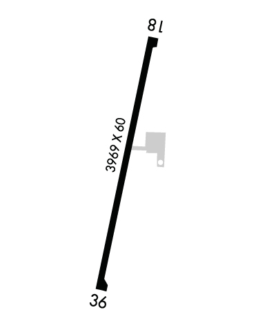
  • Runway Identifications
    Runway Identification: 18/36
    Length: 3969 ft
    Width: 60 ft
    Surface: ASPHALT-FAIR CONDITION
    Edge lights:

    Treatment: NONE

     Runway: 18   Runway: 36
    Mag heading: 183°Mag heading:
    Rwy Slope: -.71% DownRwy Slope: .71% Up
    Approach: Approach:
    Pattern: Left TrafficPattern: Left Traffic
    Markings: BASICMarkings: BASIC
    Marking Condition: FAIRMarking Condition: FAIR
    Arresting Dev: Arresting Dev:
    Lat & Long: N3606.7  W10001.5Lat. & Long.: N3606.0  W10001.6
    Elev: 2565.5 ft. MSLElev: 2537.2 ft. MSL
    TCH: TCH:
    Visual Glide Path: Visual Glide Path:
    Displaced Threshold: 196 feetDisplaced Threshold: No
    Touchdown Zone: YESTouchdown Zone: YES
    Touchdown Elev.: 2564.1 feetTouchdown Elev.: 2558.1 feet
    Visual Glide Slope: Visual Glide Slope:
    RVR Equipment: RVR Equipment:
    RVV Equipment: NORVV Equipment: NO
    Approach Lights: Approach Lights:
    REIL: NOREIL: NO
    Centerline Lights: NOCenterline Lights: NO
    Touchdown lights: NOTouchdown lights: NO
    Runway Category: Runway with a Visual ApproachRunway Category: Runway with a Visual Approach
    Declared Distances: Declared Distances:
    Obstructions: FENCEObstructions:
    Marked: NOT Marked/LightedMarked:
    Clearance slope: APCH SLOPE 15:1 AT DSPLCD THR OVR 36 FT TREES, 575 FT DSTC, 40 FT R.Clearance slope: 50:1
    Obstruction height: 7 feet AGLObstruction height:
    Dist. from runway: 201 feetDist. from runway:
    Centerline offset: Centerline offset:
    Comments: Comments:
    C:/P: