Current Weather/Notams (Metars, TAFs, Notams, NWS Forecast, PIREPS, and nearby weather)
Customs Information Send updates to Support@FltPlan.com
Customs Not Available
Database effective 04/18/2024
Airport Diagram might not be current. Facility Name: FREMONT COUNTY City Name: CANON CITY County: FREMONT State abbrev: CO State Name: COLORADO Ownership: PUBLICLY OWNED Use: OPEN TO THE PUBLIC Owner's Name: FREMONT COUNTY Address: 615 MACON CANON CITY, CO 81212 Owner's Phone: 719-276-7300 Manager's Name: WESLEY BRANDT Address: 60298 HIGHWAY 50 PENROSE, CO 81240 Phone: 719-784-3816; AFT HR - 719-429-3816. FAA Region: NORTHWEST MOUNTAIN FAA Field Office: DEN
Runway Identifications Help
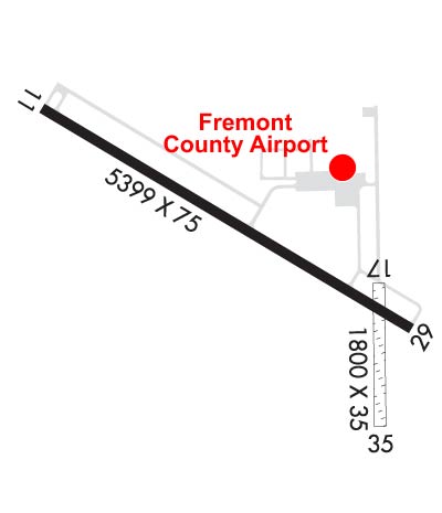
Runway Identification: 11/29 Length: 5399 ftWidth: 75 ftSurface: ASPHALT-GOOD CONDITIONEdge lights: Medium Intensity Treatment: NONE Runway: 11 Runway: 29 Mag heading: 113° Mag heading: 293° Rwy Slope: -1.12% Down Rwy Slope: 1.12% Up Approach: Approach: Pattern: Left Traffic Pattern: Left Traffic Markings: NONPRECISION INSTRUMENT Markings: PRECISION INSTRUMENT Marking Condition: FAIR Marking Condition: FAIR Arresting Dev: Arresting Dev: Lat & Long: N3826.0 W10507.0 Lat. & Long.: N3825.6 W10506.0 Elev: 5442.4 ft. MSL Elev: 5381.8 ft. MSL TCH: 23 ft. AGL TCH: 40 ft. AGL Visual Glide Path: 3.00 degrees Visual Glide Path: 3.00 degrees Displaced Threshold: No Displaced Threshold: No Touchdown Zone: YES Touchdown Zone: YES Touchdown Elev.: 5442.4 feet Touchdown Elev.: 5407.4 feet Visual Glide Slope: 2-Light PAPI on LEFT side of Runway Visual Glide Slope: 2-Light PAPI on LEFT side of Runway RVR Equipment: RVR Equipment: RVV Equipment: NO RVV Equipment: NO Approach Lights: Approach Lights: REIL: YES REIL: YES Centerline Lights: NO Centerline Lights: NO Touchdown lights: NO Touchdown lights: NO Runway Category: Runway with a Non-precision Approach having visibility minimums greater than 3/4 mile Runway Category: Runway with a Non-precision Approach having visibility minimums greater than 3/4 mile Declared Distances: Declared Distances:
Runway Identification: 17/35 Length: 1800 ftWidth: 35 ftSurface: GRASS-GOOD CONDITION-POOR CONDITIONEdge lights: Treatment: NONE Runway: 17 Runway: 35 Mag heading: 171° Mag heading: 351° Rwy Slope: -1.24% Down Rwy Slope: 1.24% Up Approach: Approach: Pattern: Left Traffic Pattern: Left Traffic Markings: Markings: Marking Condition: Marking Condition: Arresting Dev: Arresting Dev: Lat & Long: N3825.7 W10506.1 Lat. & Long.: N3825.4 W10506.1 Elev: 5386.4 ft. MSL Elev: 5364.0 ft. MSL TCH: TCH: Visual Glide Path: Visual Glide Path: Displaced Threshold: No Displaced Threshold: No Touchdown Zone: YES Touchdown Zone: YES Touchdown Elev.: 5398.1 feet Touchdown Elev.: 5395.7 feet Visual Glide Slope: Visual Glide Slope: RVR Equipment: RVR Equipment: RVV Equipment: NO RVV Equipment: NO Approach Lights: Approach Lights: REIL: NO REIL: NO Centerline Lights: NO Centerline Lights: NO Touchdown lights: NO Touchdown lights: NO Runway Category: Runway with a Visual Approach Runway Category: Runway with a Visual Approach Declared Distances: Declared Distances: Obstructions: BLDG Obstructions: Marked: NOT Marked/Lighted Marked: Clearance slope: 42:1 Clearance slope: 50:1 Obstruction height: 30 feet AGL Obstruction height: Dist. from runway: 1270 feet Dist. from runway: Centerline offset: 35 left of centerline Centerline offset: Comments: Comments: