Click here for more info on on SMS!

K1S9

SAND CANYON
CHEWELAH
WA
Time Zone: Pacific
Lat: N 4818.8
Long: W 11744.6
Elev: 2084
Var: -20
Longest Runway: 3537
CTAF: 122.9

FBO & Flight Services info for K1S9

FBOs: Update your Fuel Prices

CHEWELAH APTPh: 509-936-0234
-
Freq: 122.9
Service
Jet
100LL
SAF
MoGas
Fuel Avail: Food and Lodging at The Airport (The Inn at Sand Canyon)
Full        Last Update: 04/15/2024 17:38

Self5.996.19    
If you are an FBO, call 1-203-262-1700 to update your info or email: FltPlan.Advertising@garmin.com
Advertise your FBO on FltPlan.com

Runway & Approach Info for K1S9
Rwy
Length
Land Dist**
Approach*
  Rwy
Length
Land Dist**
Approach*
17
3537x48  3307'          
 
  
35
  3537x48  3450'          
 
 * only ILS, LOC, LDA, and SDF approaches to a specific runway are shown
** For any Declared Landing Distance Available, please see A/FD or Approach plates
Runway Weight Capability (lbs.) Help
Runway IDSingle WheelDouble WheelDouble Tandem WheelDual Double Wheel
17/35N/AN/AN/AN/A
These numbers are Advisory and are not limits.   The Airport Manager should have more accurate Weight Limits
Approach Charts
FltPlan does not have IFR approach charts available for K1S9.
Current Weather/Notams
Customs Information Send updates to Support@FltPlan.com
Customs Not Available
Database effective 04/18/2024
Airport Diagram of K1S9
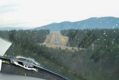
Airport Diagram might not be current.

Facility Name: CHEWELAH MUNI
City Name: CHEWELAH
County: STEVENS
State abbrev: WA
State Name: WASHINGTON
   
Ownership: PUBLICLY OWNED
Use: OPEN TO THE PUBLIC
Owner's Name: CITY OF CHEWELAH
Address: PO BOX 258
 CHEWELAH, WA 99109
Owner's Phone: 509-935-8311
  
Manager's Name: TYRONE BRYANT
Address: 139 RICHMOND LANE
 CHEWELAH, WA 99109
Phone: (509) 936-0234
   
FAA Region: NORTHWEST MOUNTAIN
FAA Field Office: SEA


Sunrise / Sunset times for CHEWELAH MUNI

DateSunriseSunset
04/18/24 Thursday5:5419:47
04/19/24 Friday5:5219:49
04/20/24 Saturday5:5019:50
04/21/24 Sunday5:4819:52
04/22/24 Monday5:4619:53
04/23/24 Tuesday5:4419:55
04/24/24 Wednesday5:4319:56
04/25/24 Thursday5:4119:58
04/26/24 Friday5:3919:59
04/27/24 Saturday5:3720:01
04/28/24 Sunday5:3620:02
04/29/24 Monday5:3420:03
04/30/24 Tuesday5:3220:05
05/01/24 Wednesday5:3120:06

Airport Facilities

Airport Attendance ScheduleUNATTENDED
Airport Status OPERATIONAL (This Status can change at any time - please check NOTAMS)
Airport Lighting ScheduleACTVT MIRL RY 17/35 - CTAF. PAPI RY 17 AND RY 35 OPER CONTINUOUSLY.
Airport Storage AvailableTie Downs
Extra Services AvailableNONE
Wind IndicatorYES - (lighted)
Control TowerNO
CTAF Frequency122.900
Unicom Frequency
Rotating Beacon ColorWG
Segmented CircleYES
Landing FeeNO

Airport Inspection Data

Airport InspectedCONTRACTOR - performed by STATE AERONAUTICAL PERSONNEL
Inspection Date08/10/2022

Airport Services

Type of Fuel AvailableGrade 100LL, JET A (freeze point -40C); -10100LL & JET A AVBL 24 HRS CREDIT CARD SELF SVC.
Airframe Repair ServiceMINOR
Power Plant Repair ServiceMINOR

Geographic Data

LatitudeN4818.8
LongitudeW11744.6 (ESTIMATED)
Arpt Elevation2084ft (ESTIMATED)
Magnetic Variation20E
0 miles NWof CHEWELAH
Traffic Pattern Altitude
Sectional ChartSEATTLE

Aircraft Data

Operations (Reported)YearlyAvg. Daily
General Aviation Transient 20005
General Aviation Local 30008
Air Taxi 00
Commerical 00
Commuter 00
Military 00
Aircraft based on Field
General Aviation Singles 22
General Aviation Multi 2
Jet Aircraft 0
General Aviation Helicopters 0
Military Aircraft 0
Gliders 0
Ultralights 0

FAA Services

FSS on field NO
FSS tie-in SEATTLE
FSS Phone 1-800-WX-BRIEF
Who issues Notams SEA
Notam D service at airport YES
ARTCC Name SEATTLE

Federal Status

Airport Certification
Aircraft Rescue & Firefighting IndexNone
Airport of EntryNo
Custom Landing RightsNo
Joint Civil/MilitaryNo
Military Landing rightsNo

Remarks

ALL PATTERNS TO THE WEST.
DEER & WILDLIFE ON & INVOF ARPT.
FOR CD CTC SEATTLE ARTCC AT 253-351-3694.
LODGING & FOOD AVBL AT APRT.
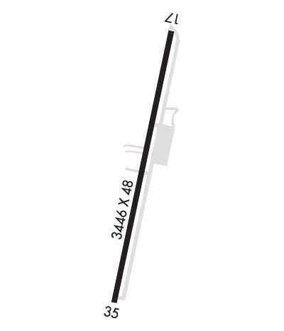
Runway Identifications
Runway Identification: 17/35
Length: 3537 ft
Width: 48 ft
Surface: ASPHALT
Edge lights: Medium Intensity

Treatment: NONE

 Runway: 17   Runway: 35
Mag heading: N/AMag heading: N/A
Approach: Approach:
Pattern: Right TrafficPattern: Left Traffic
Markings: BASICMarkings: BASIC
Marking Condition: GOODMarking Condition: GOOD
Arresting Dev: Arresting Dev:
Lat & Long: N4819.1  W11744.5Lat. & Long.: N4818.6  W11744.7
Elev: N/AElev: N/A
TCH: 63 ft. AGLTCH:
Visual Glide Path: 4.00 degreesVisual Glide Path: 3.00 degrees
Displaced Threshold: 230 feetDisplaced Threshold: 87 feet
Touchdown Zone: NOTouchdown Zone: NO
Touchdown Elev.: Touchdown Elev.:
Visual Glide Slope: 2-Light PAPI on RIGHT side of RunwayVisual Glide Slope: 2-Light PAPI on LEFT side of Runway
RVR Equipment: RVR Equipment:
RVV Equipment: NORVV Equipment: NO
Approach Lights: Approach Lights:
REIL: NOREIL: NO
Centerline Lights: NOCenterline Lights: NO
Touchdown lights: NOTouchdown lights: NO
Runway Category: Runway with a Visual ApproachRunway Category: Runway with a Visual Approach
Declared Distances: Declared Distances:
Obstructions: TREEObstructions:
Marked: NOT Marked/LightedMarked:
Clearance slope: 6:1; RWY 17 APCH SLOPE 50:1 TO DSPLCD THR.Clearance slope: 50:1
Obstruction height: 11 feet AGLObstruction height:
Dist. from runway: 275 feetDist. from runway:
Centerline offset: 63 right of centerlineCenterline offset:
Comments: 3 FT DITCH +1 FT TO +3 FT ROCKS & RD 56 FT FM THR; 77 FT L, +14 FT TREES 200 FT FM THR, AND 10 FT SIGN, 86 FT R, 53 FT FM THR.Comments:
C:/P: