Click here for more info on on SMS!

K1S6

PRIEST RIVER MUNI
PRIEST RIVER
ID
Time Zone: Pacific
Lat: N 4811.4
Long: W 11654.6
Elev: 2193
Var: -19
Longest Runway: 2983
CTAF: 122.9

FBO & Flight Services info for K1S6

FBOs: Update your Fuel Prices

AIRPORTPh: 208-263-1111
-
Freq: 122.9
Service
Jet
100LL
SAF
MoGas
Fuel Avail: NO FUEL AVAILABLE
Full        Last Update: 04/26/2024 00:15:42

Self        
If you are an FBO, call 1-203-262-1700 to update your info or email: FltPlan.Advertising@garmin.com
Advertise your FBO on FltPlan.com

Runway & Approach Info for K1S6
Rwy
Length
Land Dist**
Approach*
  Rwy
Length
Land Dist**
Approach*
01
2983x48  2983'          
 
  
19
  2983x48  2983'          
 
 * only ILS, LOC, LDA, and SDF approaches to a specific runway are shown
** For any Declared Landing Distance Available, please see A/FD or Approach plates
Runway Weight Capability (lbs.) Help
Runway IDSingle WheelDouble WheelDouble Tandem WheelDual Double Wheel
01/1912,500N/AN/AN/A
These numbers are Advisory and are not limits.   The Airport Manager should have more accurate Weight Limits
Approach Charts
FltPlan does not have IFR approach charts available for K1S6.
Current Weather/Notams
Customs Information Send updates to Support@FltPlan.com
Customs Not Available
Database effective 05/16/2024
Airport Diagram of K1S6
Airport Diagram might not be current.

Facility Name: PRIEST RIVER MUNI
City Name: PRIEST RIVER
County: BONNER
State abbrev: ID
State Name: IDAHO
   
Ownership: PUBLICLY OWNED
Use: OPEN TO THE PUBLIC
Owner's Name: BONNER COUNTY
Address: 1500 HWY 2
 SANDPOINT, ID 83684
Owner's Phone: 208-265-1438
  
Manager's Name: DAVE SCHUCK
Address: 1101 AIRPORT WAY
 SANDPOINT, ID 83864
Phone: (208) 255-9179
   
FAA Region: NORTHWEST MOUNTAIN
FAA Field Office: HLN


Sunrise / Sunset times for PRIEST RIVER MUNI

DateSunriseSunset
04/25/24 Thursday5:3819:54
04/26/24 Friday5:3619:55
04/27/24 Saturday5:3419:57
04/28/24 Sunday5:3319:58
04/29/24 Monday5:3120:00
04/30/24 Tuesday5:2920:01
05/01/24 Wednesday5:2820:03
05/02/24 Thursday5:2620:04
05/03/24 Friday5:2420:05
05/04/24 Saturday5:2320:07
05/05/24 Sunday5:2120:08
05/06/24 Monday5:2020:10
05/07/24 Tuesday5:1820:11
05/08/24 Wednesday5:1720:12

Airport Facilities

Airport Attendance ScheduleUNATTENDED
Airport Status OPERATIONAL (This Status can change at any time - please check NOTAMS)
Airport Lighting ScheduleACTVT LIRL - CTAF.
Airport Storage AvailableTie Downs
Extra Services AvailableNONE
Wind IndicatorYES - (lighted)
Control TowerNO
CTAF Frequency122.900
Unicom Frequency
Rotating Beacon Color
Segmented CircleNO
Landing FeeNO

Airport Inspection Data

Airport InspectedSTATE - performed by STATE AERONAUTICAL PERSONNEL
Inspection Date08/14/2022

Airport Services

Type of Fuel AvailableNone
Airframe Repair ServiceNONE
Power Plant Repair ServiceNONE

Geographic Data

LatitudeN4811.4
LongitudeW11654.6 (ESTIMATED)
Arpt Elevation2193ft (ESTIMATED)
Magnetic Variation19E
1 miles Nof PRIEST RIVER
Traffic Pattern Altitude
Sectional ChartGREAT FALLS

Aircraft Data

Operations (Reported)YearlyAvg. Daily
General Aviation Transient 32009
General Aviation Local 16004
Air Taxi 00
Commerical 00
Commuter 00
Military 00
Aircraft based on Field
General Aviation Singles 15
General Aviation Multi 0
Jet Aircraft 0
General Aviation Helicopters 0
Military Aircraft 0
Gliders 0
Ultralights 0

FAA Services

FSS on field NO
FSS tie-in BOISE
FSS Phone 1-800-WX-BRIEF
Who issues Notams BOI
Notam D service at airport YES
ARTCC Name SEATTLE

Federal Status

Airport Certification
Aircraft Rescue & Firefighting IndexNone
Airport of EntryNo
Custom Landing RightsNo
Joint Civil/MilitaryNo
Military Landing rightsNo

Federal Agreements

NATIONAL PLAN OF INTEGRATED AIRPORT SYSTEMS (NPIAS)
GRANT AGREEMENT HAS EXPIRED; HOWEVER, AGREEMENT REMAINS IN EFFECT FOR THIS FACILITY AS LONG AS IT IS PUBLIC USE.

Remarks

NIGHT OPNS RCMD LND RY 01; DEP RY 19.
FOR CD CTC SEATTLE ARTCC AT 253-351-3694.
RWY 01/1 9 IRREGULAR WINTER MAINTENANCE.
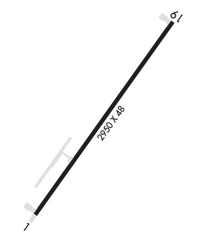
Runway Identifications
Runway Identification: 01/19
Length: 2983 ft
Width: 48 ft
Surface: ASPHALT-GOOD CONDITION
Edge lights: Low Intensity

Treatment: NONE

 Runway: 01   Runway: 19
Mag heading: 16°Mag heading: 196°
Rwy Slope: .70% UpRwy Slope: -.70% Down
Approach: Approach:
Pattern: Left TrafficPattern: Left Traffic
Markings: BASICMarkings: BASIC
Marking Condition: GOODMarking Condition: GOOD
Arresting Dev: Arresting Dev:
Lat & Long: N4811.2  W11654.8Lat. & Long.: N4811.6  W11654.4
Elev: 2172.0 ft. MSLElev: 2193.0 ft. MSL
TCH: TCH:
Visual Glide Path: Visual Glide Path:
Displaced Threshold: NoDisplaced Threshold: No
Touchdown Zone: NOTouchdown Zone: NO
Touchdown Elev.: Touchdown Elev.:
Visual Glide Slope: Visual Glide Slope:
RVR Equipment: RVR Equipment:
RVV Equipment: NORVV Equipment: NO
Approach Lights: Approach Lights:
REIL: NOREIL: NO
Centerline Lights: NOCenterline Lights: NO
Touchdown lights: NOTouchdown lights: NO
Runway Category: Runway with a Visual ApproachRunway Category: Runway with a Visual Approach
Declared Distances: Declared Distances:
Obstructions: TREEObstructions: TREES
Marked: NOT Marked/LightedMarked: NOT Marked/Lighted
Clearance slope: 15:1Clearance slope: 4:1
Obstruction height: 50 feet AGLObstruction height: 110 feet AGL
Dist. from runway: 950 feetDist. from runway: 650 feet
Centerline offset: 350 left of centerlineCenterline offset: 150 feet left of centerline
Comments: Comments:
C:/P: