Click here for more info on on SMS!

K1S5

SUNNYSIDE MUNI
SUNNYSIDE
WA
Time Zone: Pacific
Lat: N 4619.6
Long: W 11958.2
Elev: 768
Var: -19
Longest Runway: 3425
AWOS: 123.67
CTAF: 122.9

FBO & Flight Services info for K1S5

FBOs: Update your Fuel Prices

SUNNYSIDE AIRPORTPh: 509-837-5206
-
Freq: 122.9
Service
Jet
100LL
SAF
MoGas
Fuel Avail: includes all taxes
Full        Last Update: 04/05/2024 14:59

Self  6.31    
 Address: 818 E EDISON AVE   SUNNYSIDE, WA 98944
AWOSPh: 509-836-2384
-
Freq: 123.67  
If you are an FBO, call 1-203-262-1700 to update your info or email: FltPlan.Advertising@garmin.com
Advertise your FBO on FltPlan.com

Runway & Approach Info for K1S5
Rwy
Length
Land Dist**
Approach*
  Rwy
Length
Land Dist**
Approach*
07
3425x60  3425'          
 
  
25
  3425x60  3425'          
 
 * only ILS, LOC, LDA, and SDF approaches to a specific runway are shown
** For any Declared Landing Distance Available, please see A/FD or Approach plates
Runway Weight Capability (lbs.) Help
Runway IDSingle WheelDouble WheelDouble Tandem WheelDual Double Wheel
07/2512,500N/AN/AN/A
These numbers are Advisory and are not limits.   The Airport Manager should have more accurate Weight Limits
Approach Charts
FltPlan does not have IFR approach charts available for K1S5.
Current Weather/Notams
Customs Information Send updates to Support@FltPlan.com
Customs Not Available
Database effective 05/16/2024
Airport Diagram of K1S5
Airport Diagram might not be current.

Facility Name: SUNNYSIDE MUNI
City Name: SUNNYSIDE
County: YAKIMA
State abbrev: WA
State Name: WASHINGTON
   
Ownership: PUBLICLY OWNED
Use: OPEN TO THE PUBLIC
Owner's Name: CITY OF SUNNYSIDE
Address: CITY HALL, 818 EAST EDISON AVENUE
 SUNNYSIDE, WA 98944
Owner's Phone: 509-837-5399
  
Manager's Name: RAUL SANCHEZ
Address: 818 EAST EDISON AVENUE
 SUNNYSIDE, WA 98944
Phone: 509-837-5399
   
FAA Region: NORTHWEST MOUNTAIN
FAA Field Office: SEA


Sunrise / Sunset times for SUNNYSIDE MUNI

DateSunriseSunset
04/25/24 Thursday5:5420:02
04/26/24 Friday5:5320:03
04/27/24 Saturday5:5120:05
04/28/24 Sunday5:4920:06
04/29/24 Monday5:4820:07
04/30/24 Tuesday5:4620:09
05/01/24 Wednesday5:4520:10
05/02/24 Thursday5:4320:11
05/03/24 Friday5:4220:12
05/04/24 Saturday5:4020:14
05/05/24 Sunday5:3920:15
05/06/24 Monday5:3720:16
05/07/24 Tuesday5:3620:18
05/08/24 Wednesday5:3420:19

Airport Facilities

Airport Attendance ScheduleUNATTENDED
Airport Status OPERATIONAL (This Status can change at any time - please check NOTAMS)
Airport Lighting Schedule
Airport Storage AvailableTie Downs
Extra Services AvailableCrop Dusting
Wind IndicatorYES - (lighted)
Control TowerNO
CTAF Frequency122.900
Unicom Frequency
Rotating Beacon ColorWG
Segmented CircleYES
Landing FeeNO

Airport Inspection Data

Airport InspectedSTATE - performed by STATE AERONAUTICAL PERSONNEL
Inspection Date08/23/2022

Airport Services

Type of Fuel AvailableGrade 100LL
Airframe Repair ServiceNone
Power Plant Repair ServiceNone

Geographic Data

LatitudeN4619.6
LongitudeW11958.2 (ESTIMATED)
Arpt Elevation768ft (SURVEYED)
Magnetic Variation19E
2 miles Eof SUNNYSIDE
Traffic Pattern Altitude
Sectional ChartSEATTLE

Aircraft Data

Operations (Reported)YearlyAvg. Daily
General Aviation Transient 25907
General Aviation Local 10553
Air Taxi 5301
Commerical 00
Commuter 00
Military 500
Aircraft based on Field
General Aviation Singles 11
General Aviation Multi 1
Jet Aircraft 0
General Aviation Helicopters 0
Military Aircraft 0
Gliders 0
Ultralights 0

FAA Services

FSS on field NO
FSS tie-in SEATTLE
FSS Phone 1-800-WX-BRIEF
Who issues Notams 1S5
Notam D service at airport YES
ARTCC Name SEATTLE

Federal Status

Airport Certification
Aircraft Rescue & Firefighting IndexNone
Airport of EntryNo
Custom Landing RightsNo
Joint Civil/MilitaryNo
Military Landing rightsYES

Federal Agreements

NATIONAL PLAN OF INTEGRATED AIRPORT SYSTEMS (NPIAS)
GRANT AGREEMENTS UNDER FAAP/ADAP/AIP
ASSURANCES PURSUANT TO TITLE VI, CIVIL RIGHTS ACT OF 1964

Remarks

ALL ARPT PROPERTY IS USED FOR AGRI PURPOSES WI 20' OF RY.
RETRO-REFLECTIVE DEVICES ALONG TWYS.
FOR CD CTC SPOKANE APCH AT 509-742-2525, WHEN APCH CLSD CTC SEATTLE ARTCC AT 253-351-3694.
MIGRATORY GEESE.
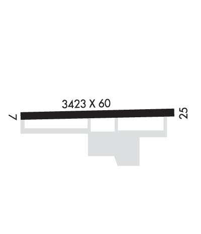
Runway Identifications
Runway Identification: 07/25
Length: 3425 ft
Width: 60 ft
Surface: ASPHALT-GOOD CONDITION
Edge lights: Low Intensity

Treatment: NONE

 Runway: 07   Runway: 25
Mag heading: 71°Mag heading: 251°
Rwy Slope: .64% UpRwy Slope: -.64% Down
Approach: Approach:
Pattern: Left TrafficPattern: Left Traffic
Markings: BASICMarkings: BASIC
Marking Condition: GOODMarking Condition: GOOD
Arresting Dev: Arresting Dev:
Lat & Long: N4619.6  W11958.6Lat. & Long.: N4619.6  W11957.8
Elev: 745.7 ft. MSLElev: 767.7 ft. MSL
TCH: TCH:
Visual Glide Path: Visual Glide Path:
Displaced Threshold: NoDisplaced Threshold: No
Touchdown Zone: YESTouchdown Zone: YES
Touchdown Elev.: 766.5 feetTouchdown Elev.: 768.0 feet
Visual Glide Slope: Visual Glide Slope:
RVR Equipment: RVR Equipment:
RVV Equipment: NORVV Equipment: NO
Approach Lights: Approach Lights:
REIL: NOREIL: NO
Centerline Lights: NOCenterline Lights: NO
Touchdown lights: NOTouchdown lights: NO
Runway Category: Runway with a Visual ApproachRunway Category: Runway with a Visual Approach
Declared Distances: Declared Distances:
Obstructions: ROADObstructions: POLE
Marked: NOT Marked/LightedMarked: NOT Marked/Lighted
Clearance slope: 8:1Clearance slope: 26:1
Obstruction height: 15 feet AGLObstruction height: 46 feet AGL
Dist. from runway: 331 feetDist. from runway: 1437 feet
Centerline offset: Centerline offset: 21 feet right of centerline
Comments: Comments: RWY 25 ACES RD 80 FT FM END OF RWY.
C:/P: