Approach Charts
| FltPlan does not have IFR approach charts available for K1O8. |
Current Weather/Notams (Metars, TAFs, Notams, NWS Forecast, PIREPS, and nearby weather)
Customs Information Send updates to Support@FltPlan.com
Customs Not Available
Database effective 05/16/2024
Airport Diagram might not be current.
|
| Facility Name: | TIPTON MUNI |
| City Name: | TIPTON |
| County: | TILLMAN |
| State abbrev: | OK |
| State Name: | OKLAHOMA |
| | |
| Ownership: | PUBLICLY OWNED |
| Use: | OPEN TO THE PUBLIC |
| Owner's Name: | CITY OF TIPTON |
| Address: | PO BOX 460 |
| | TIPTON, OK 73570 |
| Owner's Phone: | 580-667-5211 |
| | |
| Manager's Name: | BRYANT FERRIS; MAYOR. |
| Address: | 100 W. MAIN ST. |
| | TIPTON, OK 73570 |
| Phone: | 580-667-5211 |
| | |
| FAA Region: | SOUTHWEST |
| FAA Field Office: | AOK |
Runway Identifications
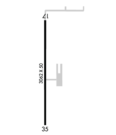
Runway Identification: 17/35Length: 3062 ft
Width: 50 ft
Surface: ASPHALT-POOR CONDITION
Edge lights: Medium IntensityTreatment: NONE
| | Runway: 17 | | Runway: 35 |
| Mag heading: | 173° | Mag heading: | 353° |
| Rwy Slope: | -.07% Down | Rwy Slope: | .07% Up |
| Approach: | | Approach: | |
| Pattern: | Left Traffic | Pattern: | Left Traffic |
| Markings: | NUMBERS ONLY | Markings: | NUMBERS ONLY |
| Marking Condition: | POOR | Marking Condition: | POOR |
| Arresting Dev: | | Arresting Dev: | |
| Lat & Long: | N3427.8 W09910.3 | Lat. & Long.: | N3427.3 W09910.3 |
| Elev: | 1248.0 ft. MSL | Elev: | 1246.0 ft. MSL |
| TCH: | | TCH: | |
| Visual Glide Path: | | Visual Glide Path: | |
| Displaced Threshold: | No | Displaced Threshold: | No |
| Touchdown Zone: | YES | Touchdown Zone: | YES |
| Touchdown Elev.: | 1248.0 feet | Touchdown Elev.: | 1248.0 feet |
| Visual Glide Slope: | | Visual Glide Slope: | |
| RVR Equipment: | | RVR Equipment: | |
| RVV Equipment: | NO | RVV Equipment: | NO |
| Approach Lights: | | Approach Lights: | |
| REIL: | NO | REIL: | NO |
| Centerline Lights: | NO | Centerline Lights: | NO |
| Touchdown lights: | NO | Touchdown lights: | NO |
| Runway Category: | Runway with a Visual Approach | Runway Category: | Runway with a Visual Approach |
| Declared Distances: | | Declared Distances: | |
| Obstructions: | POLE | Obstructions: | POLE |
| Marked: | NOT Marked/Lighted | Marked: | NOT Marked/Lighted |
| Clearance slope: | 12:1 | Clearance slope: | 2:1 |
| Obstruction height: | 34 feet AGL | Obstruction height: | 34 feet AGL |
| Dist. from runway: | 615 feet | Dist. from runway: | 265 feet |
| Centerline offset: | 250 right of centerline | Centerline offset: | 230 feet left of centerline |
| Comments: | | Comments: | |

