Current Weather/Notams (Metars, TAFs, Notams, NWS Forecast, PIREPS, and nearby weather)
Customs Information Send updates to Support@FltPlan.com
Customs Not Available
Database effective 04/18/2024
Airport Diagram might not be current.
|
| Facility Name: | LAMPSON FLD |
| City Name: | LAKEPORT |
| County: | LAKE |
| State abbrev: | CA |
| State Name: | CALIFORNIA |
| | |
| Ownership: | PUBLICLY OWNED |
| Use: | OPEN TO THE PUBLIC |
| Owner's Name: | LAKE COUNTY |
| Address: | 255 N FORBES ST |
| | LAKEPORT, CA 95453 |
| Owner's Phone: | 707-263-2341 |
| | |
| Manager's Name: | CELIA A. HOBERG |
| Address: | 255 N FORBES ST #309 |
| | LAKEPORT, CA 95453 |
| Phone: | 707-263-2341; PRINCIPAL CIVIL ENGINEER; OFFICE IN LAKEPORT, CA. |
| | |
| FAA Region: | WESTERN-PACIFIC |
| FAA Field Office: | SFO |
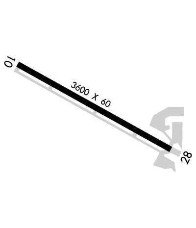
Runway Identifications
Runway Identification: 10/28Length: 3600 ft
Width: 60 ft
Surface: ASPHALT-GOOD CONDITION
Edge lights: Medium IntensityTreatment: NONE
| | Runway: 10 | | Runway: 28 |
| Mag heading: | 103° | Mag heading: | 283° |
| Rwy Slope: | -.26% Down | Rwy Slope: | .26% Up |
| Approach: | | Approach: | |
| Pattern: | Left Traffic | Pattern: | Right Traffic |
| Markings: | BASIC | Markings: | BASIC |
| Marking Condition: | GOOD | Marking Condition: | GOOD |
| Arresting Dev: | | Arresting Dev: | |
| Lat & Long: | N3859.6 W12254.4 | Lat. & Long.: | N3859.3 W12253.7 |
| Elev: | 1380.1 ft. MSL | Elev: | 1370.8 ft. MSL |
| TCH: | | TCH: | 40 ft. AGL |
| Visual Glide Path: | | Visual Glide Path: | 4.00 degrees |
| Displaced Threshold: | No | Displaced Threshold: | 85 feet |
| Touchdown Zone: | YES | Touchdown Zone: | YES |
| Touchdown Elev.: | 1380.1 feet | Touchdown Elev.: | 1376.0 feet |
| Visual Glide Slope: | | Visual Glide Slope: | 2-Light PAPI on LEFT side of Runway |
| RVR Equipment: | | RVR Equipment: | |
| RVV Equipment: | NO | RVV Equipment: | NO |
| Approach Lights: | | Approach Lights: | |
| REIL: | NO | REIL: | NO |
| Centerline Lights: | NO | Centerline Lights: | NO |
| Touchdown lights: | NO | Touchdown lights: | NO |
| Runway Category: | Runway with a Visual Approach | Runway Category: | Runway with a Visual Approach |
| Declared Distances: | | Declared Distances: | |
| Obstructions: | TREES | Obstructions: | ROAD |
| Marked: | NOT Marked/Lighted | Marked: | NOT Marked/Lighted |
| Clearance slope: | 16:1 | Clearance slope: | 2:1; APCH RATIO TO DSPLCD THR 21:1. |
| Obstruction height: | 30 feet AGL | Obstruction height: | 15 feet AGL |
| Dist. from runway: | 700 feet | Dist. from runway: | 236 feet |
| Centerline offset: | 290 right of centerline | Centerline offset: | 133 feet right of centerline |
| Comments: | | Comments: | |

