Click here for more info on on SMS!

K1N7

BLAIRSTOWN
BLAIRSTOWN
NJ
Time Zone: Eastern
Lat: N 4058.3
Long: W 07459.9
Elev: 372
Var: +13
Longest Runway: 3112
CTAF: 123.0

FBO & Flight Services info for K1N7

FBOs: Update your Fuel Prices
Come join us at Blairstown Airport located in Blairstown, New Jersey. We strive to reach your aviation needs, as we continue to improve our facilities, so you can better enjoy your experience.
Ph: 908-362-8965
-
Freq: 123.0WebsiteE-Mail
Service
Jet
100LL
SAF
MoGas
Full        Last Update: 04/05/2024 08:40

Self  5.54    
Misc. Info: Address: 36 LAMBET RD   BLAIRSTOWN, NJ 07825

If you are an FBO, call 1-203-262-1700 to update your info or email: FltPlan.Advertising@garmin.com
Advertise your FBO on FltPlan.com

Runway & Approach Info for K1N7
Rwy
Length
Land Dist**
Approach*
  Rwy
Length
Land Dist**
Approach*
07
3112x70  2794'          
 
  
25
  3112x70  2877'          
 
 * only ILS, LOC, LDA, and SDF approaches to a specific runway are shown
** For any Declared Landing Distance Available, please see A/FD or Approach plates
Runway Weight Capability (lbs.) Help
Runway IDSingle WheelDouble WheelDouble Tandem WheelDual Double Wheel
07/25N/AN/AN/AN/A
These numbers are Advisory and are not limits.   The Airport Manager should have more accurate Weight Limits
Approach Charts
Approaches    
Current Weather/Notams
Customs Information Send updates to Support@FltPlan.com
Customs Not Available
Database effective 04/18/2024
Airport Diagram of K1N7
Airport Diagram might not be current.

Facility Name: BLAIRSTOWN
City Name: BLAIRSTOWN
County: WARREN
State abbrev: NJ
State Name: NEW JERSEY
   
Ownership: PRIVATELY OWNED
Use: OPEN TO THE PUBLIC
Owner's Name: J.D. AIR INC.
Address: 17-68 RIVER ROAD
 FAIRLAWN, NJ 07410
Owner's Phone: 201-796-1556
  
Manager's Name: DENNIS KIERNAN
Address: 36 LAMBERT RD.
 BLAIRSTOWN, NJ 07825
Phone: 908-362-8965
   
FAA Region: EASTERN
FAA Field Office: HAR
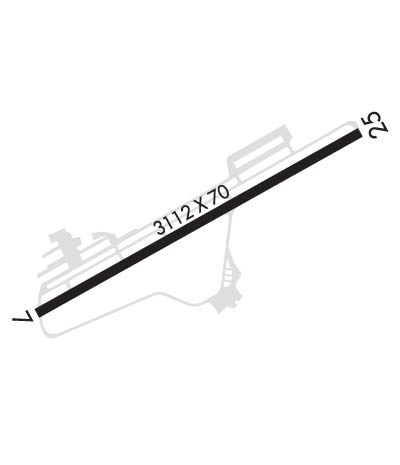

Sunrise / Sunset times for BLAIRSTOWN

DateSunriseSunset
04/18/24 Thursday6:1519:44
04/19/24 Friday6:1419:45
04/20/24 Saturday6:1219:46
04/21/24 Sunday6:1119:47
04/22/24 Monday6:0919:48
04/23/24 Tuesday6:0819:49
04/24/24 Wednesday6:0719:50
04/25/24 Thursday6:0519:51
04/26/24 Friday6:0419:52
04/27/24 Saturday6:0219:53
04/28/24 Sunday6:0119:54
04/29/24 Monday6:0019:55
04/30/24 Tuesday5:5819:56
05/01/24 Wednesday5:5719:57

Airport Facilities

Airport Attendance Schedule7 Days A Week 0700-1800
Airport Status OPERATIONAL (This Status can change at any time - please check NOTAMS)
Airport Lighting ScheduleACTVT MIRL RY 07/25-CTAF.
Airport Storage AvailableTie Downs
Extra Services AvailableGlider, Flight Instruction, Glider Towing
Wind IndicatorYES - (lighted)
Control TowerNO
CTAF Frequency123.000
Unicom Frequency123.000
Rotating Beacon ColorWG
Segmented CircleNO
Landing FeeNO

Airport Inspection Data

Airport InspectedSTATE - performed by STATE AERONAUTICAL PERSONNEL
Inspection Date05/17/2023

Airport Services

Type of Fuel AvailableGrade 100LL; -1024 HOUR SELF SERVICE
Airframe Repair ServiceMAJOR
Power Plant Repair ServiceMAJOR

Geographic Data

LatitudeN4058.3
LongitudeW07459.9 (ESTIMATED)
Arpt Elevation371ft (SURVEYED)
Magnetic Variation13W
2 miles SWof BLAIRSTOWN
Traffic Pattern Altitude
Sectional ChartNEW YORK

Aircraft Data

Operations (Reported)YearlyAvg. Daily
General Aviation Transient 791622
General Aviation Local 1222533
Air Taxi 00
Commerical 00
Commuter 00
Military 00
Aircraft based on Field
General Aviation Singles 80
General Aviation Multi 5
Jet Aircraft 0
General Aviation Helicopters 3
Military Aircraft 0
Gliders 48
Ultralights 0

FAA Services

FSS on field NO
FSS tie-in MILLVILLE
FSS Phone 1-800-WX-BRIEF
Who issues Notams MIV
Notam D service at airport YES
ARTCC Name NEW YORK

Federal Status

Airport Certification
Aircraft Rescue & Firefighting IndexNone
Airport of EntryNo
Custom Landing RightsNo
Joint Civil/MilitaryNo
Military Landing rightsNo

Remarks

GLIDERS & TOW AIRPLANES OPERATE FM TURF AREA JUST SOUTH OF RY 07/25.
TREES IN THE 7:1 TRANSITIONAL AREA ALONG RUNWAY SIDES.
HILL EAST OF ARPT MAY REQUIRE PILOTS TO EXECUTE STEEP APCH TO RY 25.
FOR CD CTC ALLENTOWN APCH AT 800-728-6322.
Airport Communications & Frequencies:
CTAF Frequency:
123.000
Unicom Frequency:
123.000
Remarks
  • NEW YORK APCH CTL PRVDS RADAR APCH/DEP SVC FROM EAST; ALLENTOWN APCH CTL PRVDS RADAR APCH/DEP SVC FROM WEST.
  • NEW YORK Primary Approach Frequencies:  
    127.6 FROM EAST
    379.9 FROM EAST
    124.45 FROM WEST
    351.8 FROM WEST
    NEW YORK Primary Departure Frequencies:  
    127.6 FROM EAST
    379.9 FROM EAST
    124.45 FROM WEST
    351.8 FROM WEST
    Runway Identifications
    Runway Identification: 07/25
    Length: 3112 ft
    Width: 70 ft
    Surface: ASPHALT
    Edge lights: Medium Intensity

    Treatment: NONE

     Runway: 07   Runway: 25
    Mag heading: 74°Mag heading: 254°
    Rwy Slope: .17% UpRwy Slope: -.17% Down
    Approach: Approach:
    Pattern: Left TrafficPattern: Left Traffic
    Markings: NONPRECISION INSTRUMENTMarkings: NONPRECISION INSTRUMENT
    Marking Condition: GOODMarking Condition: GOOD
    Arresting Dev: Arresting Dev:
    Lat & Long: N4058.1  W07500.1Lat. & Long.: N4058.4  W07459.6
    Elev: 366.2 ft. MSLElev: 371.5 ft. MSL
    TCH: TCH:
    Visual Glide Path: Visual Glide Path:
    Displaced Threshold: 318 feetDisplaced Threshold: 235 feet
    Touchdown Zone: YESTouchdown Zone: YES
    Touchdown Elev.: 371.5 feetTouchdown Elev.: 370.9 feet
    Visual Glide Slope: Visual Glide Slope:
    RVR Equipment: RVR Equipment:
    RVV Equipment: NORVV Equipment: NO
    Approach Lights: Approach Lights:
    REIL: NOREIL: NO
    Centerline Lights: NOCenterline Lights: NO
    Touchdown lights: NOTouchdown lights: NO
    Runway Category: Runway with a Non-precision ApproachRunway Category: Runway with a Non-precision Approach
    Declared Distances: Declared Distances:
    Obstructions: TREESObstructions: TREES
    Marked: NOT Marked/LightedMarked: NOT Marked/Lighted
    Clearance slope: RY 07 APCH RATIO 2:1 TO THE DSPLCD THLD.Clearance slope: RY 25 APCH RATIO 0:1 TO THE DSPLCD THLD.
    Obstruction height: 77 feet AGLObstruction height: 25 feet AGL
    Dist. from runway: 225 feetDist. from runway: 207 feet
    Centerline offset: 198 right of centerlineCenterline offset: 31 feet right of centerline
    Comments: +95 FT TREE, 4 FT FROM RY END, 225 FT LComments: +33FT TREE, 23 FT FM RWY END, 145 FT R
    C:2/P: