
| ||||||||||||||||||||||||||||||||
| ||||||||||||||||||||||||||||||||
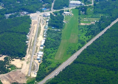
| Rwy | Rwy | |||||||
| 2400x25 | 2400' | 2400x25 | 1915' | |||||
| Runway ID | Single Wheel | Double Wheel | Double Tandem Wheel | Dual Double Wheel |
| 18/36 | 12,500 | N/A | N/A | N/A |
| These numbers are Advisory and are not limits. The Airport Manager should have more accurate Weight Limits | ||||
| FltPlan does not have IFR approach charts available for K1N2. |
| Facility Name: | SEATUCK |
| City Name: | EAST MORICHES |
| County: | SUFFOLK |
| State abbrev: | NY |
| State Name: | NEW YORK |
| Ownership: | PRIVATELY OWNED |
| Use: | OPEN TO THE PUBLIC |
| Owner's Name: | FBF SEATUCK LLC C/O VARG |
| Address: | 89-91 MONTAUK HWY |
| EAST MORICHES, NY 11940-1143 | |
| Owner's Phone: | 646-363-6297 |
| Manager's Name: | BRENDAN FREDETTE |
| Address: | 192 LEXINGTON AVE - 14TH FLOOR |
| NEW YORK, NY 10016-1143 | |
| Phone: | 646-363-6297 |
| FAA Region: | EASTERN |
| FAA Field Office: | NYC |
| Date | Sunrise | Sunset |
|---|---|---|
| 04/24/24 Wednesday | 5:58 | 19:41 |
| 04/25/24 Thursday | 5:56 | 19:42 |
| 04/26/24 Friday | 5:55 | 19:43 |
| 04/27/24 Saturday | 5:54 | 19:44 |
| 04/28/24 Sunday | 5:52 | 19:45 |
| 04/29/24 Monday | 5:51 | 19:46 |
| 04/30/24 Tuesday | 5:50 | 19:47 |
| 05/01/24 Wednesday | 5:48 | 19:48 |
| 05/02/24 Thursday | 5:47 | 19:49 |
| 05/03/24 Friday | 5:46 | 19:50 |
| 05/04/24 Saturday | 5:45 | 19:51 |
| 05/05/24 Sunday | 5:44 | 19:52 |
| 05/06/24 Monday | 5:42 | 19:53 |
| 05/07/24 Tuesday | 5:41 | 19:54 |
| Airport Attendance Schedule | MAY-OCT 7 Days A Week DALGT |
| Airport Status | CLOSED INDEFINITELY (This Status can change at any time - please check NOTAMS) |
| Airport Lighting Schedule | |
| Airport Storage Available | Tie Downs |
| Extra Services Available | Parachute Jumping |
| Wind Indicator | YES - (unlit) |
| Control Tower | NO |
| CTAF Frequency | 123.000 |
| Unicom Frequency | 123.000 |
| Rotating Beacon Color | |
| Segmented Circle | NO |
| Landing Fee | NO |
| Airport Inspected | STATE - performed by STATE AERONAUTICAL PERSONNEL |
| Inspection Date | 08/26/2022 |
| Type of Fuel Available | None |
| Airframe Repair Service | None |
| Power Plant Repair Service | None |
| Latitude | N4049.7 |
| Longitude | W07244.9 (ESTIMATED) |
| Arpt Elevation | 50ft (ESTIMATED) |
| Magnetic Variation | 14W |
| 1 miles NE | of EAST MORICHES |
| Traffic Pattern Altitude | |
| Sectional Chart | NEW YORK |
| Operations (Reported) | Yearly | Avg. Daily |
|---|---|---|
| General Aviation Transient | 100 | 0 |
| General Aviation Local | 6000 | 16 |
| Air Taxi | 0 | 0 |
| Commerical | 0 | 0 |
| Commuter | 0 | 0 |
| Military | 0 | 0 |
| Aircraft based on Field | |
|---|---|
| General Aviation Singles | 9 |
| General Aviation Multi | 0 |
| Jet Aircraft | 0 |
| General Aviation Helicopters | 0 |
| Military Aircraft | 0 |
| Gliders | 0 |
| Ultralights | 0 |
| FSS on field | NO |
| FSS tie-in | NEW YORK |
| FSS Phone | 1-800-WX-BRIEF |
| Who issues Notams | ISP |
| Notam D service at airport | YES |
| ARTCC Name | NEW YORK |
| Airport Certification | |
| Aircraft Rescue & Firefighting Index | None |
| Airport of Entry | No |
| Custom Landing Rights | No |
| Joint Civil/Military | No |
| Military Landing rights | No |
| DUE TO CLOSE PROXIMITY OF LUFKER ARPT /590 FT BTN RYS/ADHERE TO FLWG TFC PAT: N OPN--SPADARO RP LUFKER LP. S OPN--SPADARO LP LUFKER RP. ARR: INTERCEPT FINAL APCH AT 45 DEG TO FINAL APCH LEG 1500 FT FM APCH END OF RWY. DEP: MAKE 45 DEG TURN ASAP AFT TKOF TO INTCP CROSSWIND LEG. |
| FOR CD CTC NEW YORK APCH AT 516-683-2449. |
| USE S OPN FOR LNDG WHEN WINDS ARE 5 KTS OR LESS; OR WHEN WINDS ARE MORE THAN 5 KTS 90 DEG EITHER SIDE OF CNTRLN. |
| USE N OPN FOR TKOF WITH NO WIND; HVY GWT; AND FOR NOISE ABATEMENT. |
| (A89) FOR LOCAL CALL TO FSS DIAL 737-1000. |
| ULTRALGTS ON & INVOF ARPT. |
| RY 18 HAS +39 FT PLINE, 963 FT FM RY BOTH SIDES. |
| PAEW 75 FT EAST RY 18. |
| (ARPT STATUS) ARPT CLSD INDEFLY. |
| RWY 18/3 6 RWY LENGTHENED 100' EACH END |
| RWY 18/3 6 RWY WIDENED 2.5 FEET EACH SIDE |
| RWY 18/3 6 VEGETATION IN CRACKS. |
| Runway: 18 | Runway: 36 | ||
| Mag heading: | N/A | Mag heading: | N/A |
| Approach: | Approach: | ||
| Pattern: | Left Traffic | Pattern: | Right Traffic |
| Markings: | BASIC | Markings: | BASIC |
| Marking Condition: | GOOD; RY 18 MARKING FADED. | Marking Condition: | FAIR |
| Arresting Dev: | Arresting Dev: | ||
| Lat & Long: | Lat. & Long.: | ||
| Elev: | N/A | Elev: | N/A |
| TCH: | TCH: | ||
| Visual Glide Path: | Visual Glide Path: | ||
| Displaced Threshold: | No | Displaced Threshold: | 485 feet |
| Touchdown Zone: | NO | Touchdown Zone: | NO |
| Touchdown Elev.: | Touchdown Elev.: | ||
| Visual Glide Slope: | Visual Glide Slope: | ||
| RVR Equipment: | RVR Equipment: | ||
| RVV Equipment: | NO | RVV Equipment: | NO |
| Approach Lights: | Approach Lights: | ||
| REIL: | NO | REIL: | NO |
| Centerline Lights: | NO | Centerline Lights: | NO |
| Touchdown lights: | NO | Touchdown lights: | NO |
| Runway Category: | Runway with a Visual Approach | Runway Category: | Runway with a Visual Approach |
| Declared Distances: | Declared Distances: | ||
| Obstructions: | TREES | Obstructions: | PLINE; RY 36 +14 FT VARIOUS RV'S, PLANES & BLDGS, 55 FT TO 90 FT FM RY CNTRLN BOTH SIDES, FULL LENGTH OF RY. RY 36, +55 FT TREES, 353 FT FM RY, BOTH SIDES. |
| Marked: | NOT Marked/Lighted | Marked: | NOT Marked/Lighted |
| Clearance slope: | Clearance slope: | RWY 36 HAS +66 FT TREES 351 FT FROM RWY 82 FT RT, 12:1 BASED ON DSPLCD THLD. | |
| Obstruction height: | 25 feet AGL | Obstruction height: | 33 feet AGL |
| Dist. from runway: | 200 feet | Dist. from runway: | 201 feet |
| Centerline offset: | Centerline offset: | ||
| Comments: | RWY 18 +43 FT TREES 74 FT FROM RWY, 106 FT RT; +25 FT TREES 189 FT FROM RWY, 92 FT RT. | Comments: | RWY 36 +26 FT BLDG 31 FT FROM RWY, 100 FT LEFT; +29 FT BLDG 68 FT FROM RWY, 72 FT LEFT; +23 FT BLDG 43 FT FROM RWY, 72 FT LEFT; +10 FT BLDG 74 FT FROM RWY, 55 FT LEFT; +15 FT HIGHWAY 165 FT FROM RWY BOTH SIDES. |