Click here for more info on on SMS!

K1MO

MOUNTAIN GROVE MEMORIAL
MOUNTAIN GROVE
MO
Time Zone: Central
Lat: N 3707.3
Long: W 09218.6
Elev: 1476
Var: -01
Longest Runway: 2922
CTAF: 122.9

FBO & Flight Services info for K1MO

FBOs: Update your Fuel Prices

L&P AVIATIONPh: 417-926-4246
-
Freq: 122.9
Service
Jet
100LL
SAF
MoGas
Fuel Avail: NO FUEL AVAILABLE
Full        Last Update: 04/19/2024 00:01:45

Self        
If you are an FBO, call 1-203-262-1700 to update your info or email: FltPlan.Advertising@garmin.com
Advertise your FBO on FltPlan.com

Runway & Approach Info for K1MO
Rwy
Length
Land Dist**
Approach*
  Rwy
Length
Land Dist**
Approach*
08
2922x60  2922'          
 
  
26
  2922x60  2922'          
 
 * only ILS, LOC, LDA, and SDF approaches to a specific runway are shown
** For any Declared Landing Distance Available, please see A/FD or Approach plates
Runway Weight Capability (lbs.) Help
Runway IDSingle WheelDouble WheelDouble Tandem WheelDual Double Wheel
08/26N/AN/AN/AN/A
These numbers are Advisory and are not limits.   The Airport Manager should have more accurate Weight Limits
Approach Charts
Approaches    
Current Weather/Notams
Customs Information Send updates to Support@FltPlan.com
Customs Not Available
Database effective 04/18/2024
Airport Diagram of K1MO
Airport Diagram might not be current.

Facility Name: MOUNTAIN GROVE MEML
City Name: MOUNTAIN GROVE
County: WRIGHT
State abbrev: MO
State Name: MISSOURI
   
Ownership: PUBLICLY OWNED
Use: OPEN TO THE PUBLIC
Owner's Name: CITY OF MOUNTAIN GROVE
Address: 100 E. STATE, P.O. BOX 351
 MOUNTAIN GROVE, MO 65711
Owner's Phone: 417-926-4162
  
Manager's Name: RAY DAVISON
Address: 100 E. STATE STREET
 MOUNTAIN GROVE, MO 65711
Phone: (417) 926-4162
   
FAA Region: CENTRAL
FAA Field Office: NONE


Sunrise / Sunset times for MOUNTAIN GROVE MEML

DateSunriseSunset
04/19/24 Friday6:2819:48
04/20/24 Saturday6:2719:49
04/21/24 Sunday6:2619:50
04/22/24 Monday6:2519:51
04/23/24 Tuesday6:2319:52
04/24/24 Wednesday6:2219:53
04/25/24 Thursday6:2119:54
04/26/24 Friday6:2019:55
04/27/24 Saturday6:1819:56
04/28/24 Sunday6:1719:57
04/29/24 Monday6:1619:57
04/30/24 Tuesday6:1519:58
05/01/24 Wednesday6:1419:59
05/02/24 Thursday6:1320:00

Airport Facilities

Airport Attendance ScheduleCONTINUOUS
Airport Status OPERATIONAL (This Status can change at any time - please check NOTAMS)
Airport Lighting ScheduleACTVT REIL RWY 08 & 26; MIRL RWY 08/26 - CTAF.
Airport Storage AvailableTie Downs
Extra Services AvailableCrop Dusting, Flight Instruction, Annual Surveying
Wind IndicatorYES - (lighted)
Control TowerNO
CTAF Frequency122.900
Unicom Frequency
Rotating Beacon ColorWG; ROTG BCN ON WATER TOWER EAST OF ARPT.
Segmented CircleYES
Landing FeeNO

Airport Inspection Data

Airport InspectedSTATE - performed by STATE AERONAUTICAL PERSONNEL
Inspection Date07/07/2022

Airport Services

Type of Fuel AvailableNone
Airframe Repair ServiceMINOR
Power Plant Repair ServiceMAJOR

Geographic Data

LatitudeN3707.3
LongitudeW09218.6 (ESTIMATED)
Arpt Elevation1476ft (SURVEYED)
Magnetic Variation01E
3 miles SWof MOUNTAIN GROVE
Traffic Pattern Altitude
Sectional ChartKANSAS CITY

Aircraft Data

Operations (Reported)YearlyAvg. Daily
General Aviation Transient 15004
General Aviation Local 12804
Air Taxi 00
Commerical 00
Commuter 00
Military 00
Aircraft based on Field
General Aviation Singles 13
General Aviation Multi 0
Jet Aircraft 0
General Aviation Helicopters 0
Military Aircraft 0
Gliders 0
Ultralights 0; ULTRALIGHT ACTVTY ON & INVOF ARPT.

FAA Services

FSS on field NO
FSS tie-in COLUMBIA
FSS Phone 1-800-WX-BRIEF
Who issues Notams COU
Notam D service at airport YES
ARTCC Name KANSAS CITY

Federal Status

Airport Certification
Aircraft Rescue & Firefighting IndexNone
Airport of EntryNo
Custom Landing RightsNo
Joint Civil/MilitaryNo
Military Landing rightsNo

Federal Agreements

NATIONAL PLAN OF INTEGRATED AIRPORT SYSTEMS (NPIAS)

Remarks

CROP DUSTING ACFT ON & INVOF ARPT.
FOR CD CTC KANSAS CITY ARTCC AT 913-254-8508.
Airport Communications & Frequencies:
CTAF Frequency:
122.900
Remarks
  • APCH/DEP SVC PRVDD BY KANSAS CITY ARTCC ON FREQS 128.35/284.675 (RICHLAND RCAG).
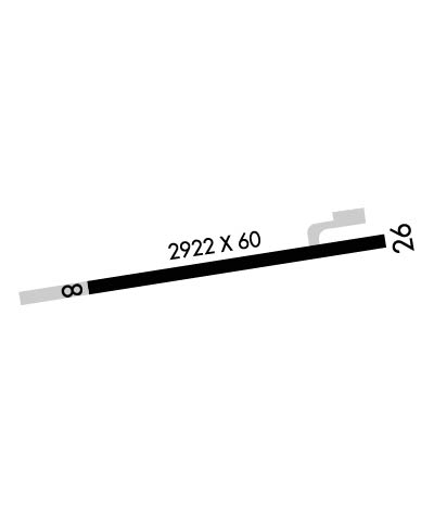
  • Runway Identifications
    Runway Identification: 08/26
    Length: 2922 ft
    Width: 60 ft
    Surface: ASPHALT
    Edge lights: Medium Intensity

    Treatment: RUBBERIZED FRICTION SEAL COAT

     Runway: 08   Runway: 26
    Mag heading: 80°Mag heading: 260°
    Rwy Slope: .82% UpRwy Slope: -.82% Down
    Approach: Approach:
    Pattern: Left TrafficPattern: Left Traffic
    Markings: NONPRECISION INSTRUMENTMarkings: NONPRECISION INSTRUMENT
    Marking Condition: GOODMarking Condition: GOOD
    Arresting Dev: Arresting Dev:
    Lat & Long: N3707.2  W09218.9Lat. & Long.: N3707.3  W09218.3
    Elev: 1452.2 ft. MSLElev: 1476.2 ft. MSL
    TCH: 43 ft. AGLTCH: 43 ft. AGL
    Visual Glide Path: 4.00 degreesVisual Glide Path: 4.00 degrees
    Displaced Threshold: NoDisplaced Threshold: No
    Touchdown Zone: YESTouchdown Zone: YES
    Touchdown Elev.: 1476.4 feetTouchdown Elev.: 1476.4 feet
    Visual Glide Slope: 2-Light PAPI on LEFT side of RunwayVisual Glide Slope: 2-Light PAPI on LEFT side of Runway
    RVR Equipment: RVR Equipment:
    RVV Equipment: NORVV Equipment: NO
    Approach Lights: Approach Lights:
    REIL: YESREIL: YES
    Centerline Lights: NOCenterline Lights: NO
    Touchdown lights: NOTouchdown lights: NO
    Runway Category: Runway with a Non-precision ApproachRunway Category: Runway with a Non-precision Approach
    Declared Distances: Declared Distances:
    Obstructions: TREESObstructions: ROAD
    Marked: NOT Marked/LightedMarked: NOT Marked/Lighted
    Clearance slope: 2:1Clearance slope: 5:1
    Obstruction height: 51 feet AGLObstruction height: 15 feet AGL
    Dist. from runway: 307 feetDist. from runway: 285 feet
    Centerline offset: 150 right of centerlineCenterline offset: 250 feet right of centerline
    Comments: RWY 8 HAS 18-54 FT TREES 0-200 FT FROM RWY END 150-228 FT RIGHT AND 195-200 FT LEFT.Comments:
    C:/P: