Click here for more info on on SMS!

K1M4

POSEY FIELD
HALEYVILLE
AL
Time Zone: Central
Lat: N 3416.8
Long: W 08736.0
Elev: 930
Var: +01
Longest Runway: 5008
AWOS: 119.52
CTAF: 122.8

FBO & Flight Services info for K1M4

FBOs: Update your Fuel Prices

HALEYVILLE ARPTPh: 205-486-8054
-
Freq: 122.8
Service
Jet
100LL
SAF
MoGas
Fuel Avail: JET A INCLUDES PRIST.
Full5.307.32    Caution: Fuel prices have not been updated in 32 days.
Last Update: 03/18/2024 15:00

Self        
 Address: 721 COUNTY ROAD 51, HALEYVILLE, AL 35565
AWOSPh: 205-486-0035
-
Freq: 119.52  
If you are an FBO, call 1-203-262-1700 to update your info or email: FltPlan.Advertising@garmin.com
Advertise your FBO on FltPlan.com

Runway & Approach Info for K1M4
Rwy
Length
Land Dist**
Approach*
  Rwy
Length
Land Dist**
Approach*
18
5008x100  5008'          
 
  
36
  5008x100  5008'          
 
 * only ILS, LOC, LDA, and SDF approaches to a specific runway are shown
** For any Declared Landing Distance Available, please see A/FD or Approach plates
Runway Weight Capability (lbs.) Help
Runway IDSingle WheelDouble WheelDouble Tandem WheelDual Double Wheel
18/3620,000N/AN/AN/A
These numbers are Advisory and are not limits.   The Airport Manager should have more accurate Weight Limits
Approach Charts
Approaches    
Current Weather/Notams
Customs Information Send updates to Support@FltPlan.com
Customs Not Available
Database effective 04/18/2024
Airport Diagram of K1M4
Airport Diagram might not be current.

Facility Name: POSEY FLD
City Name: HALEYVILLE
County: WINSTON
State abbrev: AL
State Name: ALABAMA
   
Ownership: PUBLICLY OWNED
Use: OPEN TO THE PUBLIC
Owner's Name: CITY OF HALEYVILLE
Address: 911 21ST STREET
 HALEYVILLE, AL 35565
Owner's Phone: 205-486-3121
  
Manager's Name: BRYAN CRUMPTON
Address: 721 COUNTY RD 51
 HALEYVILLE, AL 35565
Phone: 205-486-8054
   
FAA Region: SOUTHERN
FAA Field Office: JAN


Sunrise / Sunset times for POSEY FLD

DateSunriseSunset
04/18/24 Thursday6:1519:25
04/19/24 Friday6:1319:26
04/20/24 Saturday6:1219:27
04/21/24 Sunday6:1119:27
04/22/24 Monday6:1019:28
04/23/24 Tuesday6:0919:29
04/24/24 Wednesday6:0819:30
04/25/24 Thursday6:0619:31
04/26/24 Friday6:0519:31
04/27/24 Saturday6:0419:32
04/28/24 Sunday6:0319:33
04/29/24 Monday6:0219:34
04/30/24 Tuesday6:0119:34
05/01/24 Wednesday6:0019:35

Airport Facilities

Airport Attendance ScheduleMON-FRI 0800-1700; FOR SVC AFT HRS CALL 205-494-9527, FUEL UNAVBL WKENDS EXC PRIOR APVL.
Airport Status OPERATIONAL (This Status can change at any time - please check NOTAMS)
Airport Lighting ScheduleACTVT REIL RWY 18 & 36; PAPI RWY 18 & 36; MIRL 18/36 - CTAF
Airport Storage AvailableTie Downs
Extra Services AvailableNONE
Wind IndicatorYES - (lighted)
Control TowerNO
CTAF Frequency122.800
Unicom Frequency122.800
Rotating Beacon ColorWG
Segmented CircleYES
Landing FeeNO

Airport Inspection Data

Airport InspectedSTATE - performed by STATE AERONAUTICAL PERSONNEL
Inspection Date01/05/2024

Airport Services

Type of Fuel AvailableGrade 100LL, JET A
Airframe Repair ServiceNONE
Power Plant Repair ServiceNONE

Geographic Data

LatitudeN3416.8
LongitudeW08736.0 (ESTIMATED)
Arpt Elevation929ft (SURVEYED)
Magnetic Variation01W
3 miles NEof HALEYVILLE
Traffic Pattern Altitude
Sectional ChartATLANTA

Aircraft Data

Operations (Reported)YearlyAvg. Daily
General Aviation Transient 846023
General Aviation Local 17255
Air Taxi 00
Commerical 00
Commuter 00
Military 00
Aircraft based on Field
General Aviation Singles 9
General Aviation Multi 0
Jet Aircraft 0
General Aviation Helicopters 0
Military Aircraft 0
Gliders 0
Ultralights 0

FAA Services

FSS on field NO
FSS tie-in ANNISTON
FSS Phone 1-800-WX-BRIEF
Who issues Notams ANB
Notam D service at airport YES
ARTCC Name MEMPHIS

Federal Status

Airport Certification
Aircraft Rescue & Firefighting IndexNone
Airport of EntryNo
Custom Landing RightsNo
Joint Civil/MilitaryNo
Military Landing rightsYES

Federal Agreements

NATIONAL PLAN OF INTEGRATED AIRPORT SYSTEMS (NPIAS)
GRANT AGREEMENTS UNDER FAAP/ADAP/AIP
ASSURANCES PURSUANT TO TITLE VI, CIVIL RIGHTS ACT OF 1964

Remarks

FOR CD CTC MEMPHIS ARTCC AT 901-368-8453/8449.
WIDESPREAD CRACKING AND VEGETATION GROWTH ON RAMP.
Airport Communications & Frequencies:
CTAF Frequency:
122.800
Unicom Frequency:
122.800
Remarks
  • APCH/DEP SVC PRVDD BY MEMPHIS ARTCC ON FREQS 120.8/307.0 (HUNTSVILLE RCAG).
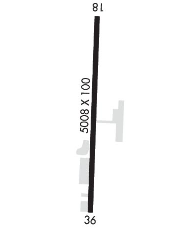
  • Runway Identifications
    Runway Identification: 18/36
    Length: 5008 ft
    Width: 100 ft
    Surface: ASPHALT
    Edge lights: Medium Intensity

    Treatment: NONE

     Runway: 18   Runway: 36
    Mag heading: 183°Mag heading:
    Rwy Slope: -.54% DownRwy Slope: .54% Up
    Approach: Approach:
    Pattern: Left TrafficPattern: Left Traffic
    Markings: NONPRECISION INSTRUMENTMarkings: NONPRECISION INSTRUMENT
    Marking Condition: GOODMarking Condition: GOOD
    Arresting Dev: Arresting Dev:
    Lat & Long: N3417.2  W08736.0Lat. & Long.: N3416.4  W08736.0
    Elev: 929.8 ft. MSLElev: 902.7 ft. MSL
    TCH: 49 ft. AGLTCH: 39 ft. AGL
    Visual Glide Path: 3.00 degreesVisual Glide Path: 3.00 degrees
    Displaced Threshold: NoDisplaced Threshold: No
    Touchdown Zone: YESTouchdown Zone: YES
    Touchdown Elev.: 929.8 feetTouchdown Elev.: 919.6 feet
    Visual Glide Slope: 4-Light PAPI on LEFT side of RunwayVisual Glide Slope: 4-Light PAPI on LEFT side of Runway
    RVR Equipment: RVR Equipment:
    RVV Equipment: NORVV Equipment: NO
    Approach Lights: Approach Lights:
    REIL: YESREIL: YES
    Centerline Lights: NOCenterline Lights: NO
    Touchdown lights: NOTouchdown lights: NO
    Runway Category: Runway with a Non-precision Approach having visibility minimums greater than 3/4 mileRunway Category: Runway with a Non-precision Approach having visibility minimums greater than 3/4 mile
    Declared Distances: Declared Distances:
    Obstructions: TREEObstructions: TREE
    Marked: NOT Marked/LightedMarked: NOT Marked/Lighted
    Clearance slope: 19:1Clearance slope: 13:1
    Obstruction height: 45 feet AGLObstruction height: 53 feet AGL
    Dist. from runway: 1067 feetDist. from runway: 935 feet
    Centerline offset: 331 right of centerlineCenterline offset: 318 feet left of centerline
    Comments: Comments:
    C:2/P: