Click here for more info on on SMS!

K1M2

BELZONI MUNI
BELZONI
MS
Time Zone: Central
Lat: N 3308.7
Long: W 09030.9
Elev: 110
Var: -03
Longest Runway: 3000
CTAF: 122.9

FBO & Flight Services info for K1M2

FBOs: Update your Fuel Prices

AIRPORT
-
Freq: 122.9
Service
Jet
100LL
SAF
MoGas
Fuel Avail: NO FUEL AVAILABLE
Full        Last Update: 04/25/2024 05:27:32

Self        
If you are an FBO, call 1-203-262-1700 to update your info or email: FltPlan.Advertising@garmin.com
Advertise your FBO on FltPlan.com

Runway & Approach Info for K1M2
Rwy
Length
Land Dist**
Approach*
  Rwy
Length
Land Dist**
Approach*
03
3000x50  3000'          
 
  
21
  3000x50  3000'          
 
 * only ILS, LOC, LDA, and SDF approaches to a specific runway are shown
** For any Declared Landing Distance Available, please see A/FD or Approach plates
Runway Weight Capability (lbs.) Help
Runway IDSingle WheelDouble WheelDouble Tandem WheelDual Double Wheel
03/2124,000N/AN/AN/A
These numbers are Advisory and are not limits.   The Airport Manager should have more accurate Weight Limits
Approach Charts
FltPlan does not have IFR approach charts available for K1M2.
Current Weather/Notams
Customs Information Send updates to Support@FltPlan.com
Customs Not Available
Database effective 05/16/2024
Airport Diagram of K1M2
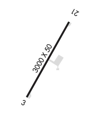
Airport Diagram might not be current.

Facility Name: BELZONI MUNI
City Name: BELZONI
County: HUMPHREYS
State abbrev: MS
State Name: MISSISSIPPI
   
Ownership: PUBLICLY OWNED
Use: OPEN TO THE PUBLIC
Owner's Name: CITY OF BELZONI
Address: PO BOX 674
 BELZONI, MS 39038
Owner's Phone: 662-247-1343
  
Manager's Name: ROB HEFLIN; CHAIRMAN ARPT BOARD.
Address: 102 W JACKSON ST
 BELZONI, MS 39038
Phone: 662-962-4840; AG OPER 662-247-4829.
   
FAA Region: SOUTHERN
FAA Field Office: JAN


Sunrise / Sunset times for BELZONI MUNI

DateSunriseSunset
04/24/24 Wednesday6:2119:40
04/25/24 Thursday6:2019:41
04/26/24 Friday6:1919:41
04/27/24 Saturday6:1819:42
04/28/24 Sunday6:1719:43
04/29/24 Monday6:1619:44
04/30/24 Tuesday6:1519:44
05/01/24 Wednesday6:1419:45
05/02/24 Thursday6:1319:46
05/03/24 Friday6:1219:47
05/04/24 Saturday6:1119:47
05/05/24 Sunday6:1019:48
05/06/24 Monday6:0919:49
05/07/24 Tuesday6:0819:50

Airport Facilities

Airport Attendance ScheduleUNATTENDED
Airport Status OPERATIONAL (This Status can change at any time - please check NOTAMS)
Airport Lighting ScheduleMIRL RWY 03/21 PRESET LOW INTST; HIGHER INTST ACTVT - CTAF.
Airport Storage AvailableTie Downs
Extra Services AvailableCrop Dusting
Wind IndicatorYES - (lighted)
Control TowerNO
CTAF Frequency122.900
Unicom Frequency
Rotating Beacon ColorWG
Segmented CircleNO
Landing FeeNO

Airport Inspection Data

Airport InspectedSTATE - performed by STATE AERONAUTICAL PERSONNEL
Inspection Date02/22/2024

Airport Services

Type of Fuel AvailableGrade 100LL; -10SELF SVC AVBL 24 HRS VIA CREDIT CARD.
Airframe Repair ServiceNONE
Power Plant Repair ServiceNONE

Geographic Data

LatitudeN3308.7
LongitudeW09030.9 (ESTIMATED)
Arpt Elevation110ft (SURVEYED)
Magnetic Variation03E
3 miles SWof BELZONI
Traffic Pattern Altitude
Sectional ChartMEMPHIS

Aircraft Data

Operations (Reported)YearlyAvg. Daily
General Aviation Transient 10403
General Aviation Local 1248534
Air Taxi 00
Commerical 00
Commuter 00
Military 00
Aircraft based on Field
General Aviation Singles 11
General Aviation Multi 0
Jet Aircraft 0
General Aviation Helicopters 0
Military Aircraft 0
Gliders 0
Ultralights 0

FAA Services

FSS on field NO
FSS tie-in GREENWOOD
FSS Phone 1-800-WX-BRIEF
Who issues Notams GWO
Notam D service at airport YES
ARTCC Name MEMPHIS

Federal Status

Airport Certification
Aircraft Rescue & Firefighting IndexNone
Airport of EntryNo
Custom Landing RightsNo
Joint Civil/MilitaryNo
Military Landing rightsYES

Federal Agreements

NATIONAL PLAN OF INTEGRATED AIRPORT SYSTEMS (NPIAS)
GRANT AGREEMENTS UNDER FAAP/ADAP/AIP
ASSURANCES PURSUANT TO TITLE VI, CIVIL RIGHTS ACT OF 1964

Remarks

THIS AIRPORT HAS BEEN SURVEYED BY THE NATIONAL GEODETIC SURVEY.
FOR CD CTC MEMPHIS ARTCC AT 901-368-8453/8449.
Runway Identifications
Runway Identification: 03/21
Length: 3000 ft
Width: 50 ft
Surface: ASPHALT-GOOD CONDITION
Edge lights: Medium Intensity

Treatment: NONE

 Runway: 03   Runway: 21
Mag heading: 29°Mag heading: 209°
Rwy Slope: .00%Rwy Slope: .00%
Approach: Approach:
Pattern: Left TrafficPattern: Left Traffic
Markings: BASICMarkings: BASIC
Marking Condition: FAIRMarking Condition: FAIR
Arresting Dev: Arresting Dev:
Lat & Long: N3308.5  W09031.1Lat. & Long.: N3308.9  W09030.8
Elev: 109.0 ft. MSLElev: 109.0 ft. MSL
TCH: 40 ft. AGLTCH: 40 ft. AGL
Visual Glide Path: 3.00 degreesVisual Glide Path: 3.00 degrees
Displaced Threshold: NoDisplaced Threshold: No
Touchdown Zone: YESTouchdown Zone: YES
Touchdown Elev.: 109.0 feetTouchdown Elev.: 109.0 feet
Visual Glide Slope: 2-Light PAPI on LEFT side of RunwayVisual Glide Slope: 2-Light PAPI on LEFT side of Runway
RVR Equipment: RVR Equipment:
RVV Equipment: NORVV Equipment: NO
Approach Lights: Approach Lights:
REIL: NOREIL: NO
Centerline Lights: NOCenterline Lights: NO
Touchdown lights: NOTouchdown lights: NO
Runway Category: Runway with a Visual ApproachRunway Category: Runway with a Visual Approach
Declared Distances: Declared Distances:
Obstructions: PLINEObstructions:
Marked: MARKEDMarked:
Clearance slope: 42:1Clearance slope: 50:1
Obstruction height: 28 feet AGLObstruction height:
Dist. from runway: 1400 feetDist. from runway:
Centerline offset: 25 left of centerlineCenterline offset:
Comments: Comments:
C:/P: