
| ||||||||||||||||||||||||||||||||||||||||||||
| ||||||||||||||||||||||||||||||||||||||||||||
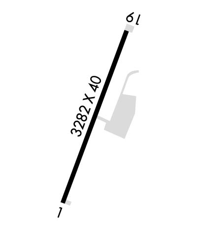
| Rwy | Rwy | |||||||
| 3282x60 | 3282' | 3282x60 | 3282' | |||||
| Runway ID | Single Wheel | Double Wheel | Double Tandem Wheel | Dual Double Wheel |
| 01/19 | 12,500 | N/A | N/A | N/A |
| These numbers are Advisory and are not limits. The Airport Manager should have more accurate Weight Limits | ||||
| FltPlan does not have IFR approach charts available for K1L8. |
 Airport Diagram might not be current. | |
| Facility Name: | GENERAL DICK STOUT FLD |
| City Name: | HURRICANE |
| County: | WASHINGTON |
| State abbrev: | UT |
| State Name: | UTAH |
| Ownership: | PUBLICLY OWNED |
| Use: | OPEN TO THE PUBLIC |
| Owner's Name: | CITY OF HURRICANE |
| Address: | 147 NORTH 870 WEST |
| HURRICANE, UT 84737 | |
| Owner's Phone: | 435-635-2811 |
| Manager's Name: | DAVE HOUSTON |
| Address: | 147 NORTH 870 WEST |
| HURRICANE, UT 84737 | |
| Phone: | 435-467-3058 |
| FAA Region: | NORTHWEST MOUNTAIN |
| FAA Field Office: | DEN |
| Date | Sunrise | Sunset |
|---|---|---|
| 04/24/24 Wednesday | 6:46 | 20:17 |
| 04/25/24 Thursday | 6:45 | 20:18 |
| 04/26/24 Friday | 6:44 | 20:19 |
| 04/27/24 Saturday | 6:42 | 20:20 |
| 04/28/24 Sunday | 6:41 | 20:21 |
| 04/29/24 Monday | 6:40 | 20:21 |
| 04/30/24 Tuesday | 6:39 | 20:22 |
| 05/01/24 Wednesday | 6:38 | 20:23 |
| 05/02/24 Thursday | 6:37 | 20:24 |
| 05/03/24 Friday | 6:36 | 20:25 |
| 05/04/24 Saturday | 6:34 | 20:26 |
| 05/05/24 Sunday | 6:33 | 20:27 |
| 05/06/24 Monday | 6:32 | 20:28 |
| 05/07/24 Tuesday | 6:31 | 20:29 |
| Airport Attendance Schedule | 7 Days A Week SR-SS |
| Airport Status | OPERATIONAL (This Status can change at any time - please check NOTAMS) |
| Airport Lighting Schedule | |
| Airport Storage Available | Tie Downs, Hanger |
| Extra Services Available | Parachute Jumping |
| Wind Indicator | YES - (unlit) |
| Control Tower | NO |
| CTAF Frequency | 123.050 |
| Unicom Frequency | 123.050 |
| Rotating Beacon Color | |
| Segmented Circle | YES |
| Landing Fee | NO |
| Airport Inspected | STATE - performed by PRIVATE CONTRACT PERSONNEL |
| Inspection Date | 09/25/2023 |
| Type of Fuel Available | Grade 100LL, JET A (freeze point -40C)MOGAS; -1024 HR SELF SVC. |
| Airframe Repair Service | MAJOR |
| Power Plant Repair Service | MAJOR |
| Latitude | N3708.4 |
| Longitude | W11318.4 (ESTIMATED) |
| Arpt Elevation | 3351ft (SURVEYED) |
| Magnetic Variation | 14E |
| 3 miles S | of HURRICANE |
| Traffic Pattern Altitude | |
| Sectional Chart | LAS VEGAS |
| Operations (Reported) | Yearly | Avg. Daily |
|---|---|---|
| General Aviation Transient | 3000 | 8 |
| General Aviation Local | 9000 | 25 |
| Air Taxi | 10 | 0 |
| Commerical | 0 | 0 |
| Commuter | 0 | 0 |
| Military | 0 | 0 |
| Aircraft based on Field | |
|---|---|
| General Aviation Singles | 39 |
| General Aviation Multi | 1 |
| Jet Aircraft | 0 |
| General Aviation Helicopters | 1 |
| Military Aircraft | 0 |
| Gliders | 1 |
| Ultralights | 1 |
| FSS on field | NO |
| FSS tie-in | CEDAR CITY |
| FSS Phone | 1-800-WX-BRIEF |
| Who issues Notams | CDC |
| Notam D service at airport | YES |
| ARTCC Name | LOS ANGELES |
| Airport Certification | |
| Aircraft Rescue & Firefighting Index | None |
| Airport of Entry | No |
| Custom Landing Rights | No |
| Joint Civil/Military | No |
| Military Landing rights | YES |
| NATIONAL PLAN OF INTEGRATED AIRPORT SYSTEMS (NPIAS) |
| GRANT AGREEMENT HAS EXPIRED; HOWEVER, AGREEMENT REMAINS IN EFFECT FOR THIS FACILITY AS LONG AS IT IS PUBLIC USE. |
| TO PRVD PATTERN SEPARATION FROM GRASSY MEADOWS ARPT, BASE LEG FOR RY 01 SHOULD BE FLOWN NORTH OF GRVL PIT LCTD 1.5 MILES SOUTH OF ARPT. |
| FOR CD CTC LOS ANGELES ARTCC AT 661-575-2079. |
| CALM WIND RWY 19. |
| Runway: 01 | Runway: 19 | ||
| Mag heading: | 4° | Mag heading: | 184° |
| Rwy Slope: | .06% Up | Rwy Slope: | -.06% Down |
| Approach: | Approach: | ||
| Pattern: | Left Traffic | Pattern: | Right Traffic |
| Markings: | BASIC | Markings: | BASIC |
| Marking Condition: | GOOD | Marking Condition: | GOOD |
| Arresting Dev: | Arresting Dev: | ||
| Lat & Long: | N3708.2 W11318.5 | Lat. & Long.: | N3708.7 W11318.3 |
| Elev: | 3345.9 ft. MSL | Elev: | 3348.0 ft. MSL |
| TCH: | TCH: | ||
| Visual Glide Path: | Visual Glide Path: | ||
| Displaced Threshold: | No | Displaced Threshold: | No |
| Touchdown Zone: | YES | Touchdown Zone: | YES |
| Touchdown Elev.: | 3351.4 feet | Touchdown Elev.: | 3351.4 feet |
| Visual Glide Slope: | Visual Glide Slope: | ||
| RVR Equipment: | RVR Equipment: | ||
| RVV Equipment: | NO | RVV Equipment: | NO |
| Approach Lights: | Approach Lights: | ||
| REIL: | NO | REIL: | NO |
| Centerline Lights: | NO | Centerline Lights: | NO |
| Touchdown lights: | NO | Touchdown lights: | NO |
| Runway Category: | Runway with a Visual Approach | Runway Category: | Runway with a Visual Approach |
| Declared Distances: | Declared Distances: | ||
| Obstructions: | Obstructions: | ROAD | |
| Marked: | Marked: | NOT Marked/Lighted | |
| Clearance slope: | 20:1 | Clearance slope: | 7:1 |
| Obstruction height: | Obstruction height: | 9 feet AGL | |
| Dist. from runway: | Dist. from runway: | 271 feet | |
| Centerline offset: | Centerline offset: | 140 feet right of centerline | |
| Comments: | Comments: |
