Approach Charts
| FltPlan does not have IFR approach charts available for K1L1. |
Current Weather/Notams (Metars, TAFs, Notams, NWS Forecast, PIREPS, and nearby weather)
Customs Information Send updates to Support@FltPlan.com
Customs Not Available
Database effective 04/18/2024
Airport Diagram might not be current.
|
| Facility Name: | LINCOLN COUNTY |
| City Name: | PANACA |
| County: | LINCOLN |
| State abbrev: | NV |
| State Name: | NEVADA |
| | |
| Ownership: | PUBLICLY OWNED |
| Use: | OPEN TO THE PUBLIC |
| Owner's Name: | LINCOLN COUNTY |
| Address: | P.O. BOX 90 |
| | PIOCHE, NV 89043 |
| Owner's Phone: | (702) 449-2418 |
| | |
| Manager's Name: | WENDY RUDDER |
| Address: | P.O. BOX 509 |
| | ALAMO, NV 89001 |
| Phone: | (702) 449-2418 |
| | |
| FAA Region: | WESTERN-PACIFIC |
| FAA Field Office: | PHX |
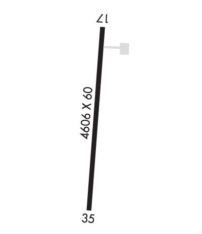
Runway Identifications
Runway Identification: 17/35Length: 4606 ft
Width: 60 ft
Surface: ASPHALT-FAIR CONDITION
Edge lights: Medium IntensityTreatment: NONE
| | Runway: 17 | | Runway: 35 |
| Mag heading: | 169° | Mag heading: | 348° |
| Rwy Slope: | -.70% Down | Rwy Slope: | .70% Up |
| Approach: | | Approach: | |
| Pattern: | Left Traffic | Pattern: | Left Traffic |
| Markings: | NONPRECISION INSTRUMENT | Markings: | NONPRECISION INSTRUMENT |
| Marking Condition: | POOR; SFC MARKS WEATHERED. | Marking Condition: | POOR; SFC MARKS WEATHERED. |
| Arresting Dev: | | Arresting Dev: | |
| Lat & Long: | N3747.6 W11425.2 | Lat. & Long.: | N3746.9 W11425.2 |
| Elev: | 4831.0 ft. MSL | Elev: | 4798.9 ft. MSL |
| TCH: | | TCH: | |
| Visual Glide Path: | | Visual Glide Path: | |
| Displaced Threshold: | No | Displaced Threshold: | No |
| Touchdown Zone: | YES | Touchdown Zone: | YES |
| Touchdown Elev.: | 4831.0 feet | Touchdown Elev.: | 4819.8 feet |
| Visual Glide Slope: | | Visual Glide Slope: | |
| RVR Equipment: | | RVR Equipment: | |
| RVV Equipment: | NO | RVV Equipment: | NO |
| Approach Lights: | | Approach Lights: | |
| REIL: | NO | REIL: | NO |
| Centerline Lights: | NO | Centerline Lights: | NO |
| Touchdown lights: | NO | Touchdown lights: | NO |
| Runway Category: | Runway with a Visual Approach | Runway Category: | Runway with a Visual Approach |
| Declared Distances: | | Declared Distances: | |
| Obstructions: | HILL | Obstructions: | |
| Marked: | LIGHTED | Marked: | |
| Clearance slope: | 17:1 | Clearance slope: | 50:1 |
| Obstruction height: | 80 feet AGL | Obstruction height: | |
| Dist. from runway: | 1600 feet | Dist. from runway: | |
| Centerline offset: | | Centerline offset: | |
| Comments: | 5 FT BRUSH IN RSA. | Comments: | 5 FT BRUSH IN RSA. |

