Approach Charts
| FltPlan does not have IFR approach charts available for K1K7. |
Current Weather/Notams (Metars, TAFs, Notams, NWS Forecast, PIREPS, and nearby weather)
Customs Information Send updates to Support@FltPlan.com
Customs Not Available
Database effective 05/16/2024
Airport Diagram might not be current.
|
| Facility Name: | FREDONIA |
| City Name: | FREDONIA |
| County: | WILSON |
| State abbrev: | KS |
| State Name: | KANSAS |
| | |
| Ownership: | PUBLICLY OWNED |
| Use: | OPEN TO THE PUBLIC |
| Owner's Name: | CITY OF FREDONIA |
| Address: | 100 N. 15TH STREET |
| | FREDONIA, KS 66736 |
| Owner's Phone: | 620-378-2231 |
| | |
| Manager's Name: | KELLEY ZELLNER - CITY ADMINISTRATOR; SHANE GLOVER, STREETS SUPERINTENDENT IS CO-MANAGER OF AIRPORT FACILITY. |
| Address: | 100 N. 15TH STREET |
| | FREDONIA, KS 66736 |
| Phone: | 620-378-2231 |
| | |
| FAA Region: | CENTRAL |
| FAA Field Office: | NONE |
Runway Identifications
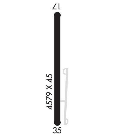
Runway Identification: 17/35Length: 4557 ft
Width: 60 ft
Surface: CONCRETE-FAIR CONDITION
Edge lights: Low IntensityTreatment: NONE
| | Runway: 17 | | Runway: 35 |
| Mag heading: | 174° | Mag heading: | 354° |
| Rwy Slope: | -.11% Down | Rwy Slope: | .11% Up |
| Approach: | | Approach: | |
| Pattern: | Left Traffic | Pattern: | Left Traffic |
| Markings: | NONPRECISION INSTRUMENT | Markings: | BASIC |
| Marking Condition: | FAIR; NSTD NPI MKGS. NO THLD BAR PRESENT. | Marking Condition: | FAIR; NSTD SMALL BSC MARKINGS |
| Arresting Dev: | | Arresting Dev: | |
| Lat & Long: | N3735.2 W09550.2 | Lat. & Long.: | N3734.5 W09550.2 |
| Elev: | 882.0 ft. MSL | Elev: | 877.0 ft. MSL |
| TCH: | | TCH: | |
| Visual Glide Path: | | Visual Glide Path: | |
| Displaced Threshold: | No | Displaced Threshold: | 541 feet |
| Touchdown Zone: | NO | Touchdown Zone: | NO |
| Touchdown Elev.: | | Touchdown Elev.: | |
| Visual Glide Slope: | | Visual Glide Slope: | |
| RVR Equipment: | | RVR Equipment: | |
| RVV Equipment: | NO | RVV Equipment: | NO |
| Approach Lights: | | Approach Lights: | |
| REIL: | NO | REIL: | NO |
| Centerline Lights: | NO | Centerline Lights: | NO |
| Touchdown lights: | NO | Touchdown lights: | NO |
| Runway Category: | Runway with a Visual Approach | Runway Category: | Runway with a Visual Approach |
| Declared Distances: | | Declared Distances: | |
| Obstructions: | POLE | Obstructions: | |
| Marked: | NOT Marked/Lighted | Marked: | |
| Clearance slope: | 9:1 | Clearance slope: | 20:1 |
| Obstruction height: | 35 feet AGL | Obstruction height: | |
| Dist. from runway: | 524 feet | Dist. from runway: | |
| Centerline offset: | 107 left of centerline | Centerline offset: | |
| Comments: | | Comments: | +15 FT ROAD 175 FT FM AER 35. |

