Current Weather/Notams (Metars, TAFs, Notams, NWS Forecast, PIREPS, and nearby weather)
Customs Information Send updates to Support@FltPlan.com
Customs Not Available
Database effective 05/16/2024
Airport Diagram might not be current.
|
| Facility Name: | DAVID JAY PERRY |
| City Name: | GOLDSBY |
| County: | MC CLAIN |
| State abbrev: | OK |
| State Name: | OKLAHOMA |
| | |
| Ownership: | PUBLICLY OWNED |
| Use: | OPEN TO THE PUBLIC |
| Owner's Name: | TOWN OF GOLDSBY |
| Address: | 100 E. CENTER ROAD |
| | GOLDSBY, OK 73093 |
| Owner's Phone: | 405-288-6675 |
| | |
| Manager's Name: | RONNY NELSON; PUBLIC WORKS DIRECTOR. |
| Address: | 351 DJP MEMORIAL BLVD., 100 E. CENTER ROAD |
| | GOLDSBY, OK 73093 |
| Phone: | 405-570-8399 |
| | |
| FAA Region: | SOUTHWEST |
| FAA Field Office: | AOK |
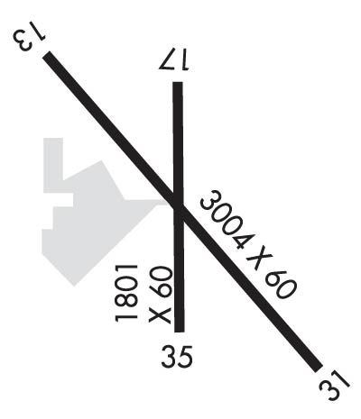
Runway Identifications
Runway Identification: 13/31Length: 3004 ft
Width: 60 ft
Surface: CONCRETE-GOOD CONDITION
Edge lights: Medium IntensityTreatment: GROOVED
| | Runway: 13 | | Runway: 31 |
| Mag heading: | 130° | Mag heading: | 310° |
| Rwy Slope: | -.35% Down | Rwy Slope: | .35% Up |
| Approach: | | Approach: | |
| Pattern: | Left Traffic | Pattern: | Left Traffic |
| Markings: | BASIC | Markings: | NONPRECISION INSTRUMENT |
| Marking Condition: | GOOD | Marking Condition: | GOOD |
| Arresting Dev: | | Arresting Dev: | |
| Lat & Long: | N3509.5 W09728.4 | Lat. & Long.: | N3509.1 W09728.0 |
| Elev: | 1167.0 ft. MSL | Elev: | 1156.6 ft. MSL |
| TCH: | | TCH: | |
| Visual Glide Path: | | Visual Glide Path: | |
| Displaced Threshold: | No | Displaced Threshold: | No |
| Touchdown Zone: | YES | Touchdown Zone: | YES |
| Touchdown Elev.: | 1167.0 feet | Touchdown Elev.: | 1167.0 feet |
| Visual Glide Slope: | | Visual Glide Slope: | |
| RVR Equipment: | | RVR Equipment: | |
| RVV Equipment: | NO | RVV Equipment: | NO |
| Approach Lights: | | Approach Lights: | |
| REIL: | NO | REIL: | NO |
| Centerline Lights: | NO | Centerline Lights: | NO |
| Touchdown lights: | NO | Touchdown lights: | NO |
| Runway Category: | Runway with a Visual Approach | Runway Category: | Runway with a Non-precision Approach having visibility minimums greater than 3/4 mile |
| Declared Distances: | | Declared Distances: | |
| Obstructions: | TREES | Obstructions: | TREES |
| Marked: | NOT Marked/Lighted | Marked: | NOT Marked/Lighted |
| Clearance slope: | 15:1 | Clearance slope: | 15:1 |
| Obstruction height: | 69 feet AGL | Obstruction height: | 35 feet AGL |
| Dist. from runway: | 1300 feet | Dist. from runway: | 725 feet |
| Centerline offset: | 192 right of centerline | Centerline offset: | 230 feet left of centerline |
| Comments: | | Comments: | |
Runway Identification: 17/35Length: 1801 ft
Width: 60 ft
Surface: ASPHALT-GOOD CONDITION
Edge lights: Treatment: NONE
| | Runway: 17 | | Runway: 35 |
| Mag heading: | 175° | Mag heading: | 355° |
| Rwy Slope: | -.44% Down | Rwy Slope: | .44% Up |
| Approach: | | Approach: | |
| Pattern: | Left Traffic | Pattern: | Left Traffic |
| Markings: | BASIC | Markings: | BASIC |
| Marking Condition: | GOOD | Marking Condition: | GOOD |
| Arresting Dev: | | Arresting Dev: | |
| Lat & Long: | N3509.5 W09728.2 | Lat. & Long.: | N3509.2 W09728.2 |
| Elev: | 1168.8 ft. MSL | Elev: | 1160.8 ft. MSL |
| TCH: | | TCH: | |
| Visual Glide Path: | | Visual Glide Path: | |
| Displaced Threshold: | No | Displaced Threshold: | No |
| Touchdown Zone: | YES | Touchdown Zone: | YES |
| Touchdown Elev.: | 1168.8 feet | Touchdown Elev.: | 1168.8 feet |
| Visual Glide Slope: | | Visual Glide Slope: | |
| RVR Equipment: | | RVR Equipment: | |
| RVV Equipment: | NO | RVV Equipment: | NO |
| Approach Lights: | | Approach Lights: | |
| REIL: | NO | REIL: | NO |
| Centerline Lights: | NO | Centerline Lights: | NO |
| Touchdown lights: | NO | Touchdown lights: | NO |
| Runway Category: | Runway with a Visual Approach | Runway Category: | Runway with a Visual Approach |
| Declared Distances: | | Declared Distances: | |
| Obstructions: | TREES | Obstructions: | |
| Marked: | NOT Marked/Lighted | Marked: | |
| Clearance slope: | 16:1 | Clearance slope: | 20:1 |
| Obstruction height: | 35 feet AGL | Obstruction height: | |
| Dist. from runway: | 780 feet | Dist. from runway: | |
| Centerline offset: | | Centerline offset: | |
| Comments: | | Comments: | |

