Click here for more info on on SMS!

K1K1

LLOYD STEARMAN FIELD
BENTON
KS
Time Zone: Central
Lat: N 3746.5
Long: W 09706.8
Elev: 1364
Var: -04
Longest Runway: 5106
Clr Del: 125.0
AWOS: 118.3
CTAF: 123.07

FBO & Flight Services info for K1K1

FBOs: Update your Fuel Prices

STEARMAN FIELDPh: 316-778-1035
-
-

AWOSPh: 316-530-6004
-
Freq: 118.3  
If you are an FBO, call 1-203-262-1700 to update your info or email: FltPlan.Advertising@garmin.com
Advertise your FBO on FltPlan.com

Runway & Approach Info for K1K1
Rwy
Length
Land Dist**
Approach*
  Rwy
Length
Land Dist**
Approach*
17
5106x75  4864'          
 
  
35
  5106x75  5106'          
 
 * only ILS, LOC, LDA, and SDF approaches to a specific runway are shown
** For any Declared Landing Distance Available, please see A/FD or Approach plates
Runway Weight Capability (lbs.) Help
Runway IDSingle WheelDouble WheelDouble Tandem WheelDual Double Wheel
17/35N/AN/AN/AN/A
These numbers are Advisory and are not limits.   The Airport Manager should have more accurate Weight Limits
Approach Charts
Approaches    
Current Weather/Notams
Customs Information Send updates to Support@FltPlan.com
Customs Not Available
Database effective 05/16/2024
Airport Diagram of K1K1
Airport Diagram might not be current.
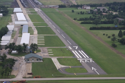
Facility Name: LLOYD STEARMAN FLD
City Name: BENTON
County: BUTLER
State abbrev: KS
State Name: KANSAS
   
Ownership: PRIVATELY OWNED
Use: OPEN TO THE PUBLIC
Owner's Name: BENTON AIRPARK INC.; RESIDENTIAL AIRPARK OWNER LIVES ON ARPT.
Address: 14789 SOUTHWEST 30TH. STREET
 BENTON, KS 67017
Owner's Phone: 316-778-1035
  
Manager's Name: DWAYNE CLEMENS
Address: 14789 SOUTHWEST 30TH. STREET
 BENTON, KS 67017
Phone: 316-648-0132; DWAYNE@CLEMENSAVIATION.COM
   
FAA Region: CENTRAL
FAA Field Office: NONE


Sunrise / Sunset times for LLOYD STEARMAN FLD

DateSunriseSunset
04/25/24 Thursday6:3920:14
04/26/24 Friday6:3820:15
04/27/24 Saturday6:3720:16
04/28/24 Sunday6:3520:17
04/29/24 Monday6:3420:18
04/30/24 Tuesday6:3320:19
05/01/24 Wednesday6:3220:20
05/02/24 Thursday6:3120:21
05/03/24 Friday6:3020:21
05/04/24 Saturday6:2820:22
05/05/24 Sunday6:2720:23
05/06/24 Monday6:2620:24
05/07/24 Tuesday6:2520:25
05/08/24 Wednesday6:2420:26

Airport Facilities

Airport Attendance Schedule7 Days A Week 0700-2300
Airport Status OPERATIONAL (This Status can change at any time - please check NOTAMS)
Airport Lighting ScheduleSS-SR
Airport Storage AvailableTie Downs, Hanger
Extra Services AvailableFlight Instruction, Aircraft Rental
Wind IndicatorYES - (lighted)
Control TowerNO
CTAF Frequency123.075
Unicom Frequency123.075; FOR CLNC DLVY CTC ICT APCH ON FREQ 134.8 OR CALL 316-946-0064.
Rotating Beacon ColorWG
Segmented CircleNO
Landing FeeNO

Airport Inspection Data

Airport InspectedSTATE - performed by STATE AERONAUTICAL PERSONNEL
Inspection Date07/02/2020

Airport Services

Type of Fuel AvailableGrade 100LL, JET A (freeze point -40C); -1024 HR CREDIT CARD, FOR JET A CALL MGR 316-648-0132.
Airframe Repair ServiceMAJOR
Power Plant Repair ServiceMAJOR

Geographic Data

LatitudeN3746.5
LongitudeW09706.8 (ESTIMATED)
Arpt Elevation1364ft (SURVEYED)
Magnetic Variation04E
1 miles SWof BENTON
Traffic Pattern Altitude
Sectional ChartWICHITA

Aircraft Data

Operations (Reported)YearlyAvg. Daily
General Aviation Transient 450012
General Aviation Local 2200060
Air Taxi 4251
Commerical 00
Commuter 00
Military 1850051
Aircraft based on Field
General Aviation Singles 185
General Aviation Multi 20
Jet Aircraft 12
General Aviation Helicopters 2
Military Aircraft 0
Gliders 0
Ultralights 0

FAA Services

FSS on field NO
FSS tie-in WICHITA
FSS Phone 1-800-WX-BRIEF
Who issues Notams ICT
Notam D service at airport YES
ARTCC Name KANSAS CITY

Federal Status

Airport Certification
Aircraft Rescue & Firefighting IndexNone
Airport of EntryNo
Custom Landing RightsNo
Joint Civil/MilitaryNo
Military Landing rightsNo

Remarks

RY 17/35 HAS BEEN WIDENED FROM 60' TO 75'.
70' WIDE CONCRETE TWY TURN OFF ADDED MIDFIELD.
FOR CD CTC WICHITA APCH AT 316-350-1520.
TURF OPS WEST OF RY.
FOR ASSISTANCE AFT HRS CALL 316-648-0132 OR NRS POSTED AT FBO.
WARBIRD, ANTIQUE & HELICOPTER OPS ON & INVOF ARPT.
UNCONTROLLED VEH TFC INVOF HANGARS & ON TWYS. ACFT BACK TAXI ON RY WHEN ABLE.
ULTRALIGHT ACFT PPR.
TWIN AND LARGER ACFT BACK TAXI ON RY.
Airport Communications & Frequencies:
Clearance Delivery Frequencies:
125.0
CTAF Frequency:
123.075
Unicom Frequency:
123.075; FOR CLNC DLVY CTC ICT APCH ON FREQ 134.8 OR CALL 316-946-0064.
WICHITA Primary Approach Frequencies:  
134.8
269.1
WICHITA Primary Departure Frequencies:  
134.8
269.1
Runway Identifications
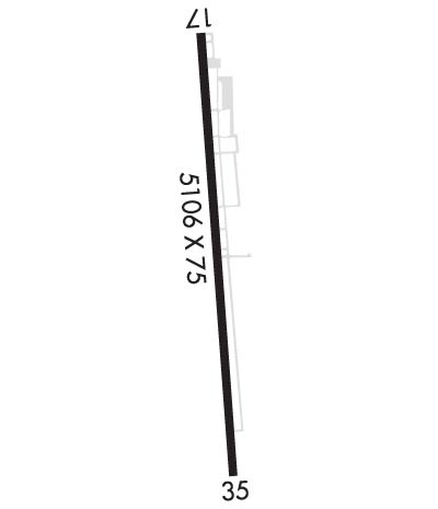
Runway Identification: 17/35
Length: 5106 ft
Width: 75 ft
Surface: ASPHALT-GOOD CONDITION
Edge lights: High Intensity

Treatment: NONE

 Runway: 17   Runway: 35
Mag heading: 172°Mag heading: 352°
Rwy Slope: -.29% DownRwy Slope: .29% Up
Approach: Approach:
Pattern: Right TrafficPattern: Left Traffic
Markings: NONPRECISION INSTRUMENTMarkings: NONPRECISION INSTRUMENT
Marking Condition: GOODMarking Condition: GOOD
Arresting Dev: Arresting Dev:
Lat & Long: N3746.9  W09706.8Lat. & Long.: N3746.0  W09706.8
Elev: 1364.1 ft. MSLElev: 1349.1 ft. MSL
TCH: 33 ft. AGLTCH:
Visual Glide Path: 3.00 degreesVisual Glide Path:
Displaced Threshold: 242 feetDisplaced Threshold: No
Touchdown Zone: YESTouchdown Zone: YES
Touchdown Elev.: 1363.1 feetTouchdown Elev.: 1350.7 feet
Visual Glide Slope: 2-Light PAPI on LEFT side of RunwayVisual Glide Slope:
RVR Equipment: RVR Equipment:
RVV Equipment: NORVV Equipment: NO
Approach Lights: Approach Lights:
REIL: NOREIL: NO
Centerline Lights: NOCenterline Lights: NO
Touchdown lights: NOTouchdown lights: NO
Runway Category: Runway with a Non-precision Approach having visibility minimums greater than 3/4 mileRunway Category: Runway with a Visual Approach
Declared Distances: Declared Distances:
Obstructions: TREESObstructions: TREES
Marked: NOT Marked/LightedMarked: NOT Marked/Lighted
Clearance slope: 26:1; APCH RATIO 18:1 OVER +15 FT ROAD 284 FT FROM DSPLCD THLD.Clearance slope: 35:1; RY 35 APCH RATIO 13:1 OVER + 18 FT ROAD 247 FT FM DSPLD THLD.
Obstruction height: 30 feet AGLObstruction height: 35 feet AGL
Dist. from runway: 980 feetDist. from runway: 1400 feet
Centerline offset: 186 left of centerlineCenterline offset:
Comments: 15 FT ROAD 40 FT FM RY END.Comments: 18 FT ROAD 157 FT FM RY END.
C:13/P: