Current Weather/Notams (Metars, TAFs, Notams, NWS Forecast, PIREPS, and nearby weather)
Customs Information Send updates to Support@FltPlan.com
Customs Not Available
Database effective 05/16/2024
Airport Diagram might not be current.
|
| Facility Name: | MEDINA MUNI |
| City Name: | MEDINA |
| County: | MEDINA |
| State abbrev: | OH |
| State Name: | OHIO |
| | |
| Ownership: | PUBLICLY OWNED |
| Use: | OPEN TO THE PUBLIC |
| Owner's Name: | CITY OF MEDINA |
| Address: | PO BOX 703 |
| | MEDINA, OH 44258-0703 |
| Owner's Phone: | 330-725-8861 |
| | |
| Manager's Name: | GREG HUBER |
| Address: | PO BOX 703 |
| | MEDINA, OH 44258-0703 |
| Phone: | 330-239-1606 |
| | |
| FAA Region: | GREAT LAKES |
| FAA Field Office: | DET |
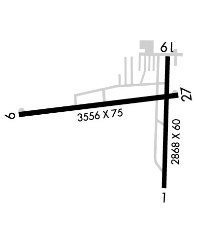
Runway Identifications
Runway Identification: 01/19Length: 2868 ft
Width: 60 ft
Surface: ASPHALT-FAIR CONDITION
Edge lights: Medium IntensityTreatment: NONE
| | Runway: 01 | | Runway: 19 |
| Mag heading: | 8° | Mag heading: | 188° |
| Rwy Slope: | .69% Up | Rwy Slope: | -.69% Down |
| Approach: | | Approach: | |
| Pattern: | Left Traffic | Pattern: | Left Traffic |
| Markings: | BASIC | Markings: | BASIC |
| Marking Condition: | GOOD | Marking Condition: | GOOD |
| Arresting Dev: | | Arresting Dev: | |
| Lat & Long: | N4107.6 W08145.7 | Lat. & Long.: | N4108.1 W08145.7 |
| Elev: | 1170.1 ft. MSL | Elev: | 1189.8 ft. MSL |
| TCH: | 25 ft. AGL | TCH: | 34 ft. AGL |
| Visual Glide Path: | 3.00 degrees | Visual Glide Path: | 4.00 degrees |
| Displaced Threshold: | No | Displaced Threshold: | 737 feet |
| Touchdown Zone: | YES | Touchdown Zone: | YES |
| Touchdown Elev.: | 1189.8 feet | Touchdown Elev.: | 1182.8 feet |
| Visual Glide Slope: | 4-Light PAPI on LEFT side of Runway | Visual Glide Slope: | 4-Light PAPI on LEFT side of Runway |
| RVR Equipment: | | RVR Equipment: | |
| RVV Equipment: | NO | RVV Equipment: | NO |
| Approach Lights: | | Approach Lights: | |
| REIL: | NO | REIL: | NO |
| Centerline Lights: | NO | Centerline Lights: | NO |
| Touchdown lights: | NO | Touchdown lights: | NO |
| Runway Category: | Runway with a Visual Approach | Runway Category: | Runway with a Visual Approach |
| Declared Distances: | | Declared Distances: | |
| Obstructions: | PLINE | Obstructions: | TREES |
| Marked: | MARKED | Marked: | NOT Marked/Lighted |
| Clearance slope: | 16:1 | Clearance slope: | 5:1; APCH SLP 16:1 DUE TO +71 FT TREE, 1347 FT FM DTHR. |
| Obstruction height: | 15 feet AGL | Obstruction height: | 71 feet AGL |
| Dist. from runway: | 450 feet | Dist. from runway: | 610 feet |
| Centerline offset: | | Centerline offset: | 175 feet left of centerline |
| Comments: | | Comments: | |
Runway Identification: 09/27Length: 3556 ft
Width: 75 ft
Surface: ASPHALT-GOOD CONDITION
Edge lights: Medium IntensityTreatment: NONE
| | Runway: 09 | | Runway: 27 |
| Mag heading: | 91° | Mag heading: | 271° |
| Rwy Slope: | .39% Up | Rwy Slope: | -.39% Down |
| Approach: | | Approach: | |
| Pattern: | Left Traffic | Pattern: | Left Traffic |
| Markings: | NONPRECISION INSTRUMENT | Markings: | NONPRECISION INSTRUMENT |
| Marking Condition: | GOOD | Marking Condition: | GOOD |
| Arresting Dev: | | Arresting Dev: | |
| Lat & Long: | N4107.9 W08146.4 | Lat. & Long.: | N4107.9 W08145.7 |
| Elev: | 1168.8 ft. MSL | Elev: | 1182.8 ft. MSL |
| TCH: | 25 ft. AGL | TCH: | 30 ft. AGL |
| Visual Glide Path: | 3.00 degrees | Visual Glide Path: | 3.50 degrees |
| Displaced Threshold: | No | Displaced Threshold: | No |
| Touchdown Zone: | YES | Touchdown Zone: | YES |
| Touchdown Elev.: | 1178.8 feet | Touchdown Elev.: | 1182.9 feet |
| Visual Glide Slope: | 4-Light PAPI on LEFT side of Runway; U/S INDEFLY. | Visual Glide Slope: | 4-Light PAPI on LEFT side of Runway |
| RVR Equipment: | | RVR Equipment: | |
| RVV Equipment: | NO | RVV Equipment: | NO |
| Approach Lights: | | Approach Lights: | |
| REIL: | NO | REIL: | YES |
| Centerline Lights: | NO | Centerline Lights: | NO |
| Touchdown lights: | NO | Touchdown lights: | NO |
| Runway Category: | Runway with a Non-precision Approach | Runway Category: | Runway with a Non-precision Approach |
| Declared Distances: | | Declared Distances: | |
| Obstructions: | TREE | Obstructions: | |
| Marked: | NOT Marked/Lighted | Marked: | |
| Clearance slope: | 13:1 | Clearance slope: | 20:1 |
| Obstruction height: | 20 feet AGL | Obstruction height: | |
| Dist. from runway: | 478 feet | Dist. from runway: | |
| Centerline offset: | 36 right of centerline | Centerline offset: | |
| Comments: | +4-6 FT BRUSH, 100-200 FT DIST, 180-200 FT R. | Comments: | |

